| Object Number | 15908 |
| Current Location | Collections Storage |
| Culture | Chinese |
| Provenience | China |
| Period | Qing Dynasty |
| Date Made | Late 19th century - 1880's |
| Section | Asian |
| Materials | Paper | Watercolor |
| Technique | Watercolor |
| Iconography | Plan | Burial Location |
| Inscription Language | Chinese Language |
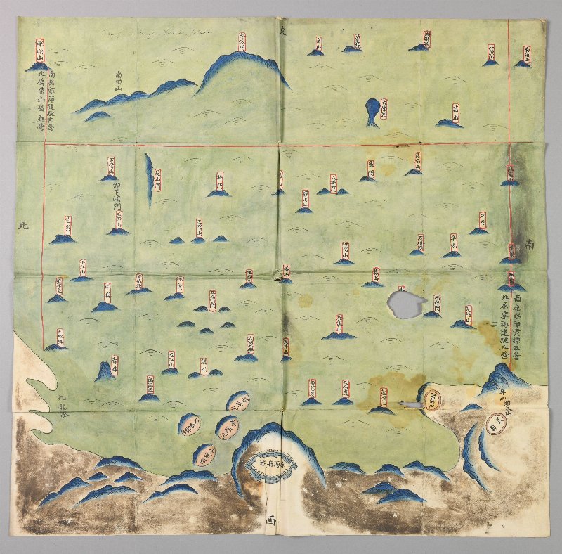
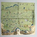
| Description | Chinese map showing the county town of Ninghai (寧海縣城), with numerous small islands off the coast, and specifying divisions between administrative districts. Ninghai is located on China’s east coast, about 200km south of Shanghai across the Hangzhou Bay. It and many of the other names that appear on the map can be readily identified with place names on modern maps. The map belongs to a Chinese tradition of cartography in which features are pictorially rendered, and distances and relative positions are not shown to scale. Maps belonging to this tradition were widely used in the 17th-19th centuries for representing administrative districts for coastal defense purposes, and it is likely that this map would have had such a function. Compared with the more elaborate examples, which often represent much larger sections of the coast, this is a relatively simple map showing the administrative extent of just a single county town.The map is oriented with East at the top, as if looking out over the East China Sea from the walled town of Ninghai at the bottom. The most distant features represented on the map (such as the island of Tantoushan 檀頭山) are about 60km away from Ninghai. Scales appear to have been considerably compressed in an E-W direction, and the nominal East of the map is in fact more like Southeast. Ruled red lines indicate the limits of responsibility of three administrative units, the Ninghai Jiantiao Left Garrison 寧海徤跳左營, the Linhai Huangbiao Left Garrison 臨海黃標左營 to the south, and the Xiangshan Changshi Garrison 象山昌石營 to the north. There is no explicit record of the date or for whom the map was produced. The map was received from Gregory Bernard Keen (Librarian. University of Pennsylvania, 1887-1898). At the top, an annotation in English incorrectly identifies the map as a “Plan of a Chinese burial place,” presumably because the labeled islands bear a passing resemblance to graves. |
| Length | 50.5 cm |
| Width | 52.2 cm |
| Credit Line | Gift of Mr. Keen, 1893 |
Report problems and issues to digitalmedia@pennmuseum.org.