This page includes information that may not reflect the current views and values of the Penn Museum. |
PRINIATIKOS PYRGOS EXCAVATION:1
In 2004 a second small kiln (kiln 2) was exposed by wave erosion on the northwestern slopes of the promontory. A rescue excavation was therefore initiated in 2005 by Dr. Metaxia Tsipopoulou of the 24th Greek Archaeological Department, Aghios Nikolaos (Hayden is field director). This excavation has begun to reveal the scope of prehistoric and historical industrial activity, which is embedded within the larger prehistoric and historical harbor settlement. This settlement is demonstrated by well-preserved architectural remains and pottery.
Excavation of the settlement and related industrial quarter will address three issues and related questions that pertain to east Cretan and Aegean archaeology:
1) Cultural history and development: How does the development of this large diachronic coastal center accord with, or differ from, other contemporary sites in eastern Crete, especially those recently excavated sites along the eastern side of the Gulf? What can the Greek phases of settlement, for example, reveal concerning the inception, development, and history of this coastal polis? What do the Roman phases demonstrate concerning the role Crete played in long-distance trade? What does this settlement reveal concerning the agricultural and manufacturing base, regional consumption, and exchange networks across the Gulf and in the southern Aegean? For earlier periods, does the rise of palatial Gournia in the Late Bronze Age accord with the decline of adjacent, possibly ancillary sites in the Gulf? What is the chronological range of the large Neolithic coastal settlement that underlies the Bronze Age site? What are its links to central Crete and the Cyclades? Is development continuous at this coastal center from the Neolithic through the Bronze Age?
2) Regional Industries: a) Ceramic production: What are the products, chronological range, and technological developments of ceramic manufacture? Can these ceramics be differentiated from other production centers?; can trade networks and perhaps polity be traced through the distribution of these ceramics? b) Iron smelting: Can chronological range and manufacturing techniques be determined? What can this investigation reveal concerning the relationship of Crete and Cyprus from the Early Iron Age to the early Greek period? Is there a Phoenician presence? Does this technology contribute to the economic and political development of Early Iron Age regional powers such as Vrokastro, and 7th-6th c. B.C. city-states, such as the nearby polis of Istron?
3) Environment: How were regional resources used in craft production and agriculture? What opportunities and constraints were presented by these resources?
Summary of Results of the 2005 Excavation by Trench
In 2005 four trenches were initially opened on the western to central part of the promontory2. These were excavated by M. Eaby (U. of North Carolina, Chapel Hill); J. Ott (New York University, American School); A. Stamos (Temple University, INSTAP Study Center) and Dr. H. Dierckx (Classical Studies, Elmira College, NY). In addition to trenches placed over possible ceramic kilns/furnaces in area A (trench A1000), and architectural relics in area G (trench G2000), one trench (G1000) was placed over the large Minoan ceramic kiln [1] eroding out of the west scarp, and in area H, on the eroded northwest slopes, another trench (H1000) was placed over the small kiln [2] revealed in 2004.


Area H
Three 5 by 5 meter trenches were eventually opened in area H on the eroded northwest slopes of the promontory around the small kiln that appeared in 2004. Because this is an eroded slope with shallow soil, no baulks were used between trenches.
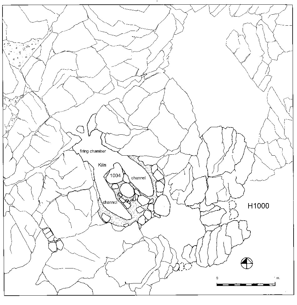
Trench H10001
The small kiln (kiln 2: H1004) in trench H1000 is approximately 1 m. wide and 1.50 m. long. It is oriented northwest-southeast and has two channels separated by a wall, with a firing chamber on the down slope (western) side, closer to the sea and placed to utilize the northwest updraft winds2. This kiln can be described as either a channel or updraft type. The kiln walls consisted of calcined small stone and mud packing forming the curved exterior eastern wall; this encircling wall is partially preserved on the south and north sides of the kiln, and projecting bedrock was also used in kiln construction. Within some of these crevices a great deal of broken pottery was found, with sherds dated primarily to the Early Minoan period. This pottery was accompanied by burned and raw clay and carbon.
Two surfaces were found in the two channels of the kiln, a lower burned mud-packing on the bedrock, and a higher surface of burned mud (both 6-8 cm. thick), the upper separated from the lower by 20-25 cm. of burned soil. It is possible that these two surfaces might indicate two periods of use. The few sherds found in this soil between the two surfaces were primarily Early Minoan in date, although one sherd, a so-called 'beehive' shape with incised cross-hatched lines on the interior, is probably later (Middle to Late Minoan). These sherds cannot be used to establish the chronology of the kiln, however, as they might have been washed into the opening between the two layers of mud-packing from the west. Pots to be fired in a channel kiln would normally have been placed on stone slabs set to span the channels, allowing hot air to flow from the small western firing chamber under and over the vessels. A hole in the dome allowed heat and smoke to exit the kiln. In this case, possibly the vases were placed on the thick clay layer spanning the channel.
Small half-formed bits of clay that had been pinched into rough shapes were also recovered from this trench and from H3000 (and were found in trench G1000 as well, near the larger kiln). These were fired and sometimes one pinched end was hastily pricked or incised; these roughly worked small pieces of clay may have been used to stack or set vases in the kiln. A very large burned tripod(?)3 leg was also found in the kiln in the second pass, near the southern end of the east channel. Other examples of these large 'legs' were recovered from this trench and from trench G1000 to the south, where another large ceramic kiln was excavated. At present their purpose is unknown. Although all are burned (either thoroughly or at the tip), some still retain clay slip and they were made on reed mats, as the flat side of the 'leg' sometimes retains the woven impression. They are consistently tempered with granodiorite, chaff, quartz, limestone, and gold mica. These may have been the legs of huge cauldrons or baking plates, or the legs might have been used to hold up firing platforms in kilns, or perhaps were used (individually) to block the opening in the top of the kiln to produce a reduction atmosphere. With further excavation, more artifacts that could be interpreted as kiln equipment or furniture may be identified.
The mixed chronology of the sherds found between the two surfaces in the kiln cannot provide a firm date for this small structure. Another similar kiln, of Late Minoan I date, has been excavated in an industrial quarter at the nearby harbor settlement at Mochlos, east of the Isthmus of Hierapetra (Soles et al. 2003: 80-89, fig. 52). This similarity in structure suggests that the Priniatikos Pyrgos example also belongs to the Late Bronze Age.Trench H20001
Excavation will continue in 2006 in trench H2000, located directly east of trench H1000. Surface cleaning in this trench revealed evidence of metalworking in the form of a large convex piece of iron slag possibly from the bottom of a shaft furnace, bits of bronze, and two lead rivets, mold-made. Bits of melted glass may suggest other industrial activities, and obsidian was also found in this trench. Bronze Age, plentiful historical pottery, stone tools, bone, plaster, and carbon were also recovered. In the southeastern corner, part of a large wall was revealed, and abundant pebbles, possibly from a destroyed floor located east of the wall.
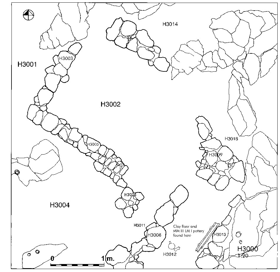
Trench H30001
Trench H3000 revealed part of a probable Minoan workshop area located directly south of the small kiln in trench H1000. H3000 is defined by small rooms and Minoan (Bronze Age) walls bedded on soil. From the first removal of surface soil, stone tools, obsidian, sherds, and mud packing were revealed. Excavation of the area H3003 on the western side of the trench revealed a number of marine shells washed up against the base of the north-south wall H3003 2. Part of a bronze pin, an olive pit, and stone weights were found in Area H3002, in the center of the trench. This material was interpreted by the excavator as slope wash. In the southwest corner of the trench (locus H3004), two 5-cm. diameter holes were found drilled into a large stone that is probable bedrock. These holes are not aligned, but open at different angles. Thus their function is not understood; excavation will continue in 2006 in the area around this feature. Flanking this area on the north is wall H3005, which extends southeast, widens, and turns into a broad wall H3006 that may have functioned as a platform or bench.
Bronze Age floors were found near walls H3008, H3013, and H3009, composed of pebble packing covered by a thin smoothed layer of yellow-white clay. Located just above this floor between the walls oriented northeast-southwest (H3008 and H3013) were painted fine-ware cups. These are of probable early Neopalatial date; one has flaring walls and a vertical handle3. One cup was found upright, and a long clay water-channel or drain with handles was found directly east, parallel to wall H3013, and bedded on a floor4. A Middle Minoan II-III date for this water channel is suggested by its coarse clay fabric, which contains abundant granodiorite.
The irregular limestone bedrock surface in trench H3000 was leveled by enclosing depressions with small stones and filling in these areas with cobbles, stone tools, and sherds taken from other areas of the site. Although surface pottery was mixed, the majority of these sherds packed into the karst depressions belonged to the Early Bronze Age, especially to the Vasilike ware style. A large variety of pottery shapes in Vasilike Ware were recovered from this trench and from trench H1000, including small jars and jugs, bowls, conical and footed globular cups, trays, and larger storage shapes5. Vasilike Ware is a hard-fired ceramic with a burnished, mottled surface with color varying from red to orange and red-brown to black. The mottled surface color is deliberate and produced in the firing of the vessel. At least three clay fabrics were identified in Vasilike Ware, and the quality of these vases (e.g., firing, surface treatment, care in shaping) varies widely. The presence of granodiorite inclusions in the clay fabrics of some of these Vasilike vases also indicates local manufacture, probably at Priniatikos Pyrgos.


Area G
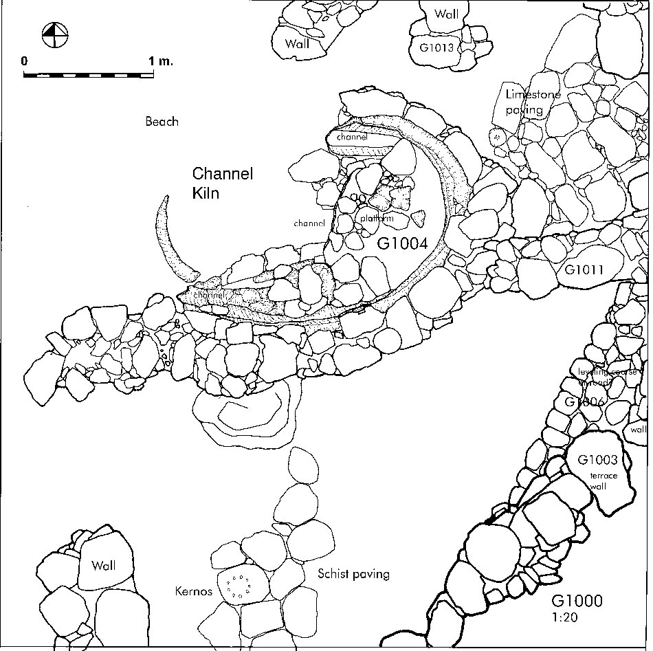
Trench G10001
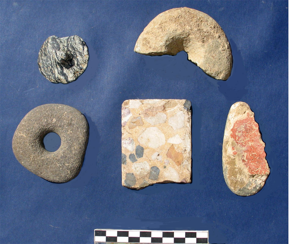
Area G is located 30 meters to the south of area H, along the lower west slopes of the promontory. One trench, G1000, was opened up on a steep slope around a large kiln (kiln 1: G1004) which had been eroding out of the slope for over a decade. Excavation along the east side of this trench revealed a deep cross-section of strata that illustrates much of the history of the site, from Final Neolithic/Early Minoan through the Roman period2. The highest stratum (loci G1001-G1008) consists of loose gray soil, 1.5 meters thick, containing everything from modern garbage to pottery of all periods. Near the surface and throughout this upper stratum several extremely vitrified sherds of Late Roman date testify to the presence of a Roman ceramic kiln on the site2a. Also found in these passes of gray soil were parts of iron and bronze artifacts, loomweights, glass, a small greenstone lid, burned clay, and groundstone tools3.
A large and loosely built terrace wall (G1003) is located at the highest elevation along the east side of the trench. It survives in three courses and judging by its depth, could belong to the Greek or later periods. The base of this terrace wall is ca. 1.50 m. below the modern surface, at the bottom of the modern-to-recent loose gray soil stratum. Below and slightly to the west of the large terrace is another wall, G1006, built of cobble-sized stone. This wall is three to four stones wide and one course high, and appears to be a leveling course or perhaps part of a road, as the top surface of these cobbles is worn. This cobble wall is bedded on a thick, deep yellow-brown soil/clay layer on the south side of the trench, which descends to the excavated base of the trench. Directly below this cobble wall, a thin stratum of yellow clay suggests a possible floor. This possible surface was associated with Late Minoan pottery.
Below this potential floor, the yellow-brown, claylike soil stratum extends downward to a depth of over one meter. It contains small pieces of white lime plaster, Minoan sherds, carbon, small rocks, and patches of red, burned clay. The claylike soil may be derived from ancient construction--either mudbrick or roofing material. More Middle and Late Minoan pottery was recovered from the north side of the trench, especially from 1.50 m. below the surface. Other finds from this trench include stone weights and tools, obsidian blades and flakes, metal fragments, a bone pin or needle, and in the baulk along the northeastern side of the trench, a small painted clay boat of Bronze Age date4. Fragments of possible potters' wheels and clay bats for holding vases on the wheel were also recovered. Much of the pottery recovered from the deep yellow soil stratum dated to the Neopalatial period (MM III-Late Minoan I), although LM III (Postpalatial) sherds were also found in the trench5.
At the base of the yellow stratum, narrow strata or lens of yellow-white clay were seen in the baulk interbedded or lying over thin strata of beach pebbles. These thin strata could be prepared surfaces or floors laid over pebble packing, and these strata extend in the eastern baulk to the north edge of the trench (similarly prepared surfaces were also found in trenches H3000 and G2000). Below these lens a paving made of green schist was revealed, with one paving stone having an incised 'kernos,' a Minoan form associated with cult and used to hold offerings (see the plan, above)6. Early Minoan sherds of third millennium date began to be found at this level, suggesting that the paving may belong to this period, but more excavation needs to be completed in this area before the date of the paving can be established. The schist paving is on the same approximate level as the lower of two limestone pavements found on the north side of the trench (see the plan of the trench, above).
A large Late Minoan ceramic channel kiln, G1004, is the central feature of this trench (see the plan of the trench, above), and the kiln is located between the north and south pavements. The kiln contains three channels or flues and parts of these are still preserved7. These channels extend west to a firing chamber that the sea has destroyed. The southern exterior wall preserves an east-west dimension for the kiln of over 3 meters, indicating that the structure is a large example of its type. The small cobbled-sized stones carefully packed over a thick clay platform at the preserved back of the kiln may have been placed there as a surface for pottery to be fired. Pottery found in strata near the kiln suggest a date of Middle Minoan III through Late Minoan I(A?) for this structure.
This type of kiln is known from several other sites on the island and belongs to the Neopalatial period. A larger and well-published example of this type was found at the Minoan harbor of Kommos in southern Crete (Shaw et al. 2001: 20), and others have been found at Vathypetro, Aghia Triada, Phaistos, Knossos, and Zakros. The presence of these two kilns indicates that Priniatikos Pyrgos was a probable pottery production center and coastal distribution point for regional ceramics in the early Neopalatial period, and possibly during earlier periods as well. These vases manufactured at the site can be identified or traced because of one key marker--the presence of the igneous rock temper--granodiorite. Thus ceramics produced at Priniatikos Pyrgos may be traceable in the archaeological and historical record. This ability to track the distribution of pottery from Priniatikos Pyrgos provides a unique opportunity to record trade contacts within the Mirabello area, eastern Crete, and the Aegean. The Roman-period wasters found at Priniatikos Pyrgos also indicate pottery was manufactured here in the historical period, and this may prove useful in reconstructing trade networks for the later periods.
The presence of these two kilns indicates that Priniatikos Pyrgos was a probable pottery production center and coastal distribution point for regional ceramics during the Bronze Age, as were other Minoan coastal sites, such as Kommos in the south (Shaw 1997, 2000, 2001), and Gouves (Vallianou 1997) and Mochlos (Soles et al., 1997, 2000) on the north coast. These vases were exports to be sold abroad or shipped as containers for regional produce (for example, wine, honey, oil). Wasters (very burned sherds) of Roman date from the site also indicate that ceramic production continued into the historical periods. Because pottery manufactured at the site contains granodiorite temper, it is possible that the distribution of these ceramics can be traced in eastern Crete and beyond.


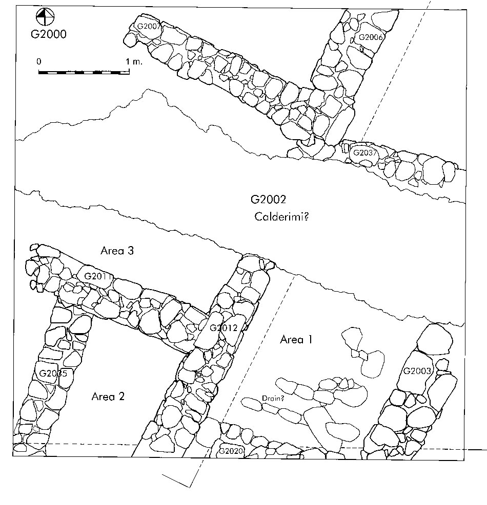
Trench G20001
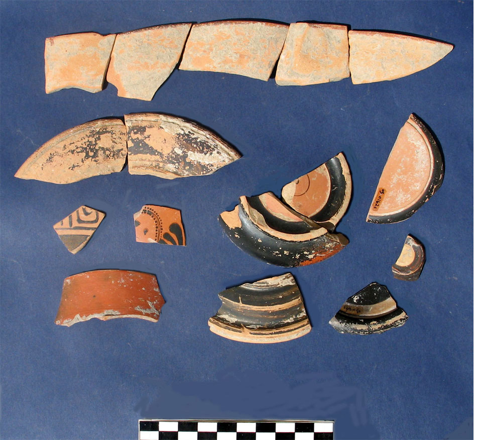
Trench G2000 was placed on the level surface above and just southeast of the slope containing trench G1000. This trench was placed in an area where remote sensing indicated habitations and possible kilns. Almost immediately below the surface a cobbled east-west narrow road or 'calderimi' was found of probable Venetian or Ottoman date. This road was built over walls of one (or two) Roman structures (walls G2006, 2007, 2012). The more massive wall in the southeastern corner of the trench, G2003, may have been the external wall of this structure. No Roman floor was found associated with these walls, which are quite close to the surface. Below the Roman walls, fragmentary walls of probable Greek date were found, based on the associated pottery (G2020, G2037) along the south side of the trench and north of the calderimi. In the southeast corner, Area 1, and extending into Area 2 and 3, a thick deposit or midden of Greek pottery accompanied by ash, bone, shell, and stone tools was found ca. 60 cm. below the surface. The gray ashy soil was collected for sediment flotation of stratified paleobotanical and zooarchaeological remains. This will occur in an regional environment already carefully documented in terms of the extent of agricultural potential and production, soil conditions, and plant communities (Vrokastro Reports 2, 3).
The ash deposit contained high-quality Greek pottery2 predominantly of the sixth through fourth century B.C., although some sherds could belong to the Early Iron Age (LM IIIC/PG)3. This Greek-period pottery consists primarily of fine and medium-coarse wares (cups, bowls, basins, jugs and jars) and is both locally produced, based on observation of clay fabrics, and imported (including Attic black-glazed wares and sherds with red-figure decoration). These vases will provide insights concerning trade contacts and the extent and nature of regional ceramic production during the Greek period. At the bottom of this deposit, a quern was located in an upright position, surrounded by stone tools, the assemblage suggesting a floor. This floor was of yellow, claylike soil, hard-packed and identical in color and consistency to the deep yellow strata of trench G1000. The quern and stone tools were also located on a level that accords with the base of the probable Greek wall G2020 in the south baulk, 1.10 m. below the surface.
Below this, a stratum (G2028) of yellowish brown hard-packed soil with small pebbles and rocks was found; this produced little pottery and bone, but some carbon and many stone tools. The presence of carbon and the claylike dense soil suggests roofing material. A possible bin was excavated in the northeast corner of Area 1. Another feature (G2032) appears to be a stone-built drain, paralleling the southern baulk4. No certain floor could be associated with the base of this drain. The last stratum (G2030) excavated in Area 1, at a depth of 1.30 m., revealed more hard yellow claylike soil with many small pieces of white plaster, these not horizontal in the soil but angled into this surface. The presence of this plaster indicates the depth and location of a possible damaged floor. On this possible floor, sherds recovered belonged to both the Greek period and the Bronze Age.
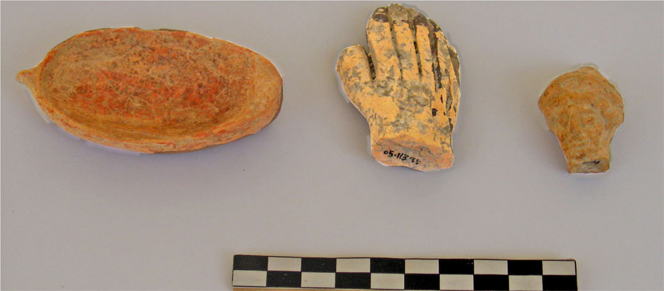
Area 2, in the southwestern part of trench G2000, produced two thick strata of gray-brown and yellowish brown soil after removal of the upper gray loose soil. These units contained stone tools, glass, loomweights, and a quern. The next stratum, G2018, contained the head of a small terracotta figurine5. The yellowish brown soil continued from this point with bits of carbon to the top of a large, well-preserved, probable Bronze Age wall (G2035), oriented north-northeast-south-southwest6. This wall was composed of rounded pieces of limestone, in contrast to the later Greek and Roman walls, that were built of more angular limestone. The base of wall G2035 is associated with a contemporary floor to the east located at a depth of 1.40 m. below the surface. This floor consists of bits of white plaster (better preserved, but corresponding in appearance and depth, at 1.40 m., to stratum/floor G2030 in Area 1, directly east). Bits of white plaster were found with pieces of burnished red plaster, perhaps from the floor surface. Only a few Bronze Age sherds were found on this floor (these were Middle and Late Minoan), thus the floor may have been cleaned off for later construction. Wall G2035 suggests the presence of well-preserved Bronze Age phases within the overall multi-period settlement area. One of the objectives for the 2006 fieldwork season is to continue the excavation of this small area. It should be noted that the possible Bronze Age floors identified in Areas 1 and 2 accord in depth and composition to the first Bronze Age surface identified within nearby Trench G1000.
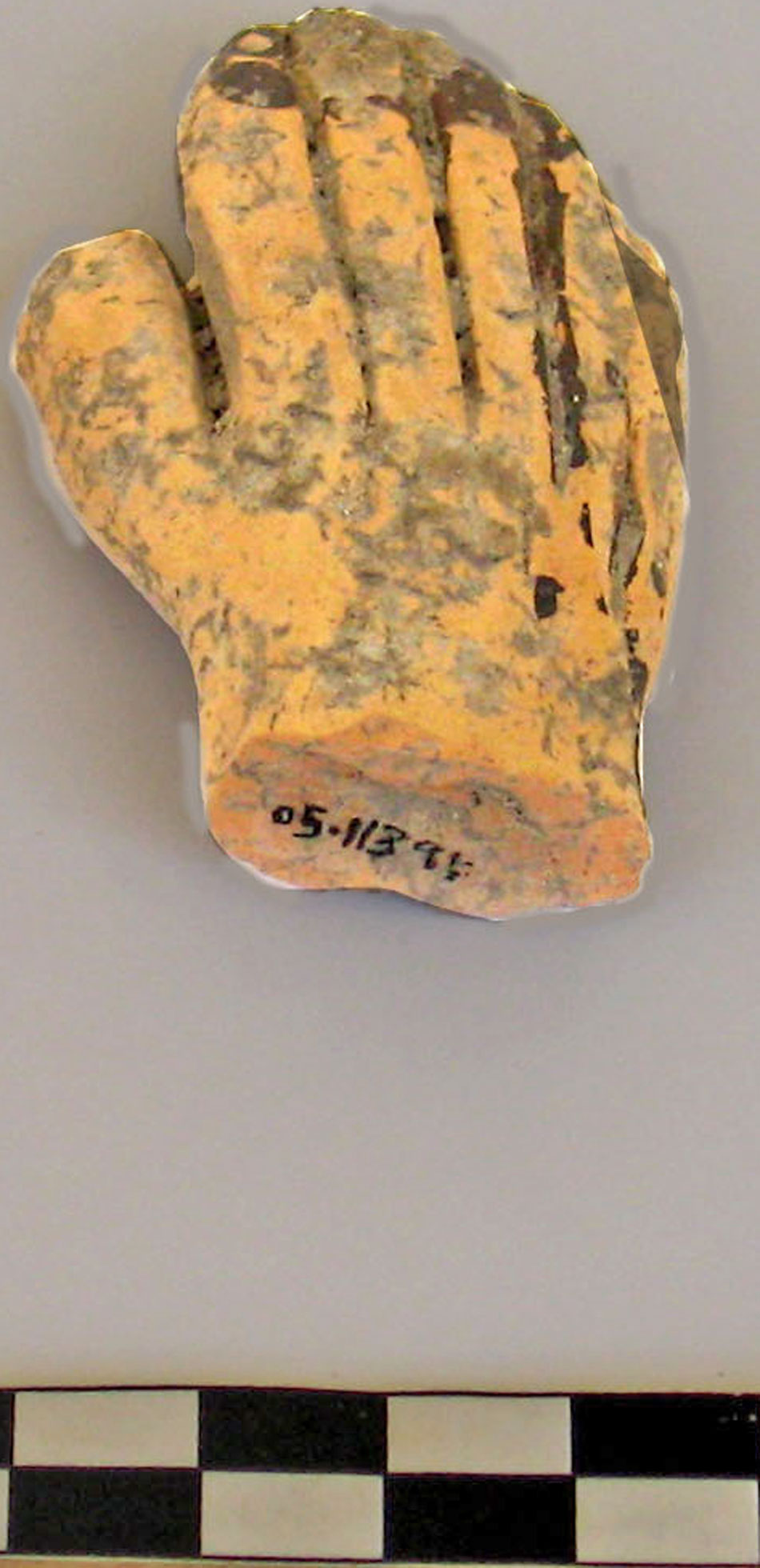
Directly north, the narrow Area 3 is defined by the southern side of the calderimi, which will be removed in 2006, and wall G2011 on the south7. This is part of another interior room that again revealed the western end of the ashy deposit that was detected in Area 1. In this area another pebble-packed Greek floor was identified, dated by the sherds found on this surface, accompanied by the large painted hand of a ceramic figurine8. This Greek surface accords in depth to the higher Greek floor (G2017) identified in Area 1.
The structures within Area G belong to both the prehistoric period and to later phases of historical antiquity. Some of these buildings could be the habitations of craftsmen who were involved in production of ceramics and metal at the site. Further excavation of this trench and area G has the potential to reveal the nature of prehistoric and historical (Greek and Roman) habitation and industrial activity, as well as data concerning agriculture and pastoralism within the region (derived from flotation of sediments and study of animal bone). Remote sensing in area G also indicated the likely presence of more kilns and furnaces, located directly south of trench G2000. With further excavation, the relationship between the deep strata in the scarp (G1000) and the strata under the level surface of the hill top (G2000) will be understood, and the relationship between these habitations and industrial activity explicated.


Area A
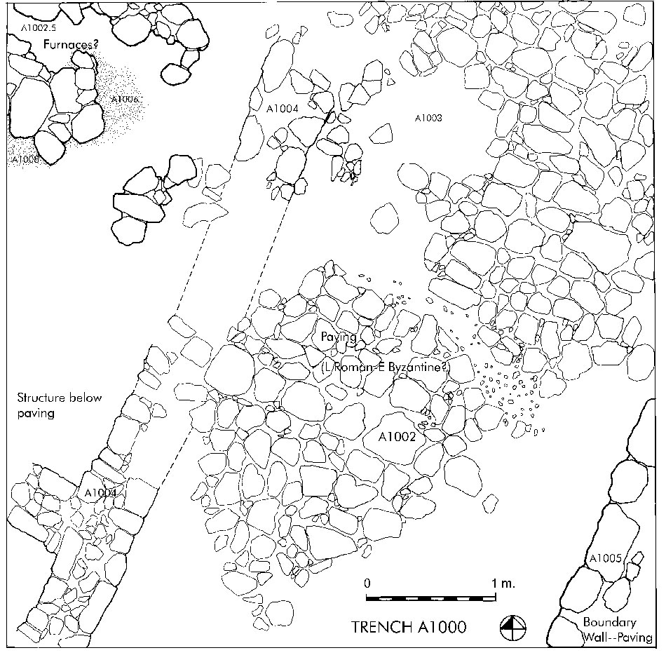
Trench A10001
To the east and toward the center of the promontory, trench A1000 was placed in an area where remote sensing identified possible smelting furnaces or ceramic kilns. The trench was placed on the southeastern slope of the promontory, 20 m. below the crest of the headland, where the ruined apse of the chapel can still be seen. This foundation is identified in local tradition with a chapel dedicated to the Panaghia (Virgin), and held to be the oldest of the coastal chapels. Excavation revealed at 0.40 m. below the surface a broad, well-preserved, worn limestone paving of possible Late Roman or Byzantine date2. The paving, possibly a road or a plateia (courtyard), extends across the trench toward the northeast, perhaps leading up to the chapel. Since the pavement was not continuous across the entire trench, excavation continued at its edges, in an attempt to determine its date. On the west side of the paving, and 15 cm. below it, a wall (A1004) was found extending to the northeast. It is composed for part of its length of small pieces of schist along the wall top, suggesting a leveling course for a mudbrick wall above. Pieces of limestone are used for most of its coursing, however, and two interior rooms to the west are indicated by a wall extending west with a right-angle. A few Greek sherds were found on the top of this wall, and a small area excavated to its east revealed hard-packed sandy soil. The date of the structure has not been determined, but it may be Greek or Roman.
At the southeastern corner, a wall of larger stones (A1005), some set on-edge, is oriented to the northeast and appears to be the formal edge or boundary of the paving. The small angular pieces of loosely 'set' stone 10-15 cm. below the paving in this area appears to be a rough bedding course for the paved surface.
At the northwest corner of the trench (A1006, A1008, A1002.5), small to large pieces of rubble enclose small curved areas containing fine burned gray-black soil3. These small curved walls are packed with bits of burned clay that appears to be fused with iron slag, suggesting that these features were probable iron-smelting shaft furnaces. Directly to the south of the possible small shaft furnace A1008, a piece of burned, curved furnace lining was recovered. These possible furnaces are not located directly on the level of the limestone paving, but are pedestalled on earth 10-15 cm. above the pavement. This suggests that the metallurgical activity, at least in this area, may be late or post-antique.
Three types of slag were also found in the trench: large to small pieces of iron slag; a glassy, green-colored lighter slag (derived from copper or iron smelting, or from glass?); and a light, coarse crystalline, glassy black and white slag. The first type of slag indicates the smelting of iron ore, though glass or lime may also have been manufactured in this area. Directly west and outside the trench, a large area of slag has been identified, strewn across the western slopes of the promontory (this area is now cultivated in cactus)4. Judging by the size of this slag heap, it is probable that many more furnaces will be identified with further excavation of the area. According to the results of the geophysical prospection, these lie to the north and northwest of trench A1000.
In addition to slag and related material, parts of iron spikes, some small pieces of bronze (probable bits of jewelry), stone tools, tile, plaster, and Roman glass were recovered from this trench. A few Bronze Age sherds were recovered from large units of pottery that were primarily Roman-Byzantine/Venetian in date, with some sherds from later periods.
Trench A2000
Two passes taken across the trench directly north (A2000) revealed probable wall collapse in the north central part of the trench, possibly part of the church complex. This mound of debris was mixed with plaster and tile roofing fragments. Iron spikes and a large iron hinge were also found, and much more slag was found along the south side of this second trench. Continued excavation in this area has the potential to reveal a late Roman/early Byzantine chapel or small basilica complex and a larger part of the metalworking aspects of the site.
Mapping ProjectAntonia Stamos of the INSTAP Study Center began a mapping project with an EDM on the site after the close of the excavation. The first task was to map the location of trenches and features. A contour mapping project was then begun that continued for three weeks, and mapping of most of the promontory was completed in 2005. Contour mapping will continue in the Kambos, between Priniatikos Pyrgos and Nisi Pandeleimon, which is the location of the large prehistoric and historical harbor town.
Conclusions
Continued excavation of Priniatikos Pyrgos will reveal the cultural development of the region through exploration of the largest prehistoric and historical coastal site in central-western Mirabello, and the industrial and agricultural base that sustained and transformed this long-term settlement. A developing exchange network in industrial and agricultural products can also be documented in Crete and the southern Aegean, this extending from the fourth millennium B.C. through the first millennium A.D. Few well-preserved coastal sites of this chronological and functional range have been investigated within Crete. Continued exploration of this coastal site is key to understanding the cultural and economic development of west-central Mirabello from the Final Neolithic to the Late Roman/Byzantine periods.