| Vijayanagara Today |
|
After the destruction and abandonment of the Vijayanagara capital, the area reverted to its previous primitive agricultural and pastoral base. Successive monsoons undoubtedly breached tanks and silted canals. We speculate that the small population was located on the edge of irrigable areas. Successive
government Gazetteers provide information about changes in the area
during the past century. The earliest, the Madras District Gazetteer
for Bellary District, was published in 1904 and was compiled by W.
Francis. Rainfall was low, about 27 inches per annum in the town of
Hospet. The Hospet Taluk with the Tungabhadra River forming its northern
boundary, boasted the largest area under irrigation, more than 18,500
acres or 14% of cultivated areas. Cholam, korra, rice, and cambu constituted
the principal crops. Rice cultivation accounted for about 8% of the
total area in crops, compared The District had one of the lowest populations of any area within the Madras Presidency, just under a million people (Francis 1904: 52). The population of the Hospet division was just over a hundred thousand, of which 28% lived in one of the two towns (Hospet and Kampli) while the remainder resided in 121 villages. The population of Hospet was almost 18,500. It was sustained in part by various government offices (Assistant Collector, Tahsildar, and District Court) and by the railway. The chief industry was cotton weaving; raw sugar or jaggery was a significant product of sugar cane growing. The population of Kamalapura was 6,000, which largely supported itself on paddy and sugar cane grown on some 450 acres of land irrigated from the large Kamalapura tank that was fed by the renovated Raya channel that brought water from the Tungabhadra. Until replaced by cheaper English goods, the village was a centre of iron smelting and the manufacture of large shallow iron pans in which sugar cane juice was boiled down. In 1904 a small fort dominated the centre of the town. It may have been built after the fall of the capital; in 1820 it was the residence of the Raja of Anegondi. At this time half the population spoke Kannada while Telugu was spoken by one-third and Hindi by one-twelfth. Smaller numbers spoke Marathi and even fewer, Lambadi. About ninety percent belonged to various Hindu sects, including Lingayats, which may have been twelve percent of the population, while almost ten percent were Muslim. Jains and Christians were small minorities. The village of Hampi was described as “a tiny fever-stricken hamlet... of no importance itself….” (Francis 1904: 259). The Virupaksha temple in Hampi did not attract the large crowds at festival time as it was thought to have done previously. The most popular village cults were those devoted to Hanuman and to various form of the goddess. However, the ruins of the capital attracted visitors, some of whom stayed in the Traveller’s Bungalow in Kamalapura. One measure of their importance: of 28 pages devoted to the Hospet Taluk, Frances uses half to describe the site. At this time, the Tungabhadra formed the boundary between Bellary District and the Dominions of the Nizam of Hyderabad. Thus, parts of the site to the north of the river, including the village of Anegondi, were not described. The
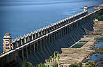
Vijayanagara site continued to be located in a comparatively remote
and backward area until well after Indian Independence in 1947. With
the completion of the Tungabhadra Dam and associated hydro-electric
facilities located east of Kamalapura, the area experienced rapid
change. Availability of water led to an intensification of agriculture
and the provision of electricity supported industrial development.
Both lead to a rapid growth in the local population. |
||||
 |
||||
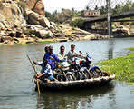
| Coracle |
||||
 |
||||
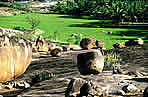
| Paddy
Field |
||||
 |
||||
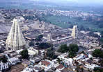
| Hampi
Village |
||||
| Top |