“Cian mic Cainte was a wicked Druid who kept an academy near Drogheda, and was wont to change his pupils into swine for the purpose of amusing himself. This wicked practice having at length become known to the friends of his pupils . . . the three sons of Tureann resolved to take revenge on the Druid.” “To save himself from them, he changed his form into that of a black pig . . . Brian turned his two brothers into hounds, who chased the magical pig.” “He fled across the country, leaving a deep track behind him.” The preceding is a combination of the Prophecies of St. Columbkill (Kearney 1856) as quoted by Mr. W. F. De Vismes Kane and additional versions of the legend as given by the latter.
The legend has many versions (Lett quotes in extenso one related by Dr. Donovan in 1835, and one from the Book of Lecan), “The froth from his mouth was the first whiskey ever made in Ireland.” That isn’t all, he will return, there will be a great slaughter of all who don’t get across the Boyne or the Shannon. “When the Black Pig reaches Athlone he will not be able to cross the Shannon and the end of the world will come.”
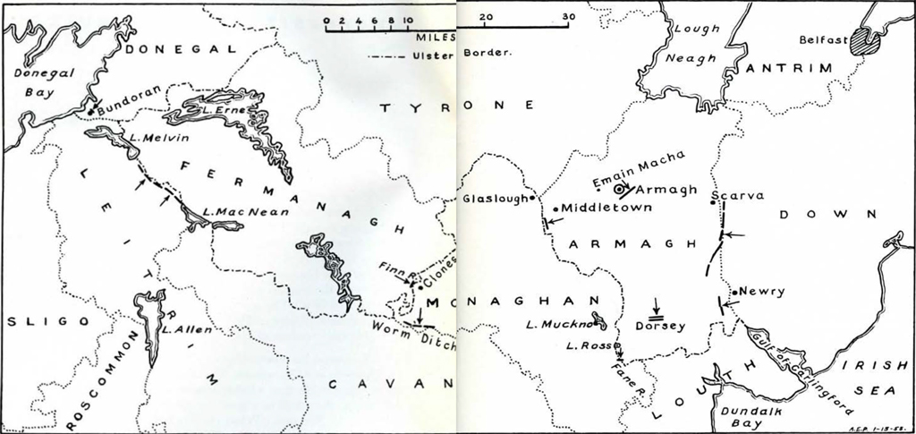
What has all this to do with a sober study of prehistory? Only that to this pig, in a manner to out-Bunyan the great Paul, is legendarily attributed the production of prehistoric earthworks all over northern Ireland and particularly the Black Pig’s Dyke described as a one time continuous wall from Bundoran on the Atlantic Ocean across all Ireland to Newry at the head of the gulf of Carlingford of the Irish Sea, forming the ancient and much of the recent boundary of Ulster.
When my friend Sir Shane Leslie, the well known author, first told us of this historic wall which had never been properly surveyed, it seemed an unusual challenge. Imagine being the first to survey the great wall of China or Hadrian’s wall across Scotland! When Sir Shane offered his castle in Glaslough, County Monaghan, with a library collected by many generations, as about the most luxurious headquarters any archaeological expedition ever enjoyed, we could not resist the temptation.
All books on Irish archaeology published since 1928, which I can find, simply report the wall as a fact with in one case a red line clear across Ireland and then north to Scarva to mark its course. Dr. O. G. S. Crawford, the leading field archaeologist and editor of Antiquity, was good enough to write me, “It would be a most useful piece of work just to trace its course on the ground and mark it in as you go along (over the hedges and dykes)!” He had begun this some 20 years ago but had not been able to complete it.
Mr. W. F. De Vismes Kane’s 1909 Royal Irish Academy Paper, “The Black Pig’s Dyke: The Ancient Boundary Fortification of Uladh” (Ulster), was the first report of the work that distinguished antiquarian did on the subject, his second, correcting, paper being published in 1917. Earlier work was done by Dr. John O’Donovan in 1835 and Canon Lett about the turn of the century but the present theory is basically Kane’s. He finds that there were three lines of fortification across Ireland each representing a boundary of Ulster which was gradually being pushed back by the southern kingdoms until, in the fourth century A.D., the line in question was broken through by the three brothers Colla and Emain Macha, storied capital of the northern Ulidian kingdom, was destroyed. The remnants of the Ulidians, also known as Cruithni or Picts, were apparently forced to the east and there threw up another line, the “Dane’s Cast,” to protect themselves. This, Kane, however, reports as part of the same line. Sir Shane thinks the Ulidians were the original smaller dark inhabitants of Ireland (the Chuchulain saga covers this period and that hero of the north is represented as small and dark).
Kane’s studies were before the clay when the automobile had made all parts of the line accessible in a few hours’ drive and he had to depend on correspondents. Sir Shane, in many ways Kane’s successor in the work, made extracts of letters from 26 of these. Kane’s nephew had made all his papers available, and we had the important originals. It seemed, especially as most of his line was located only by inference, that we should be able to contribute something.
The first task was to obtain 1909 Ordnance Survey maps on the six inches-to-the-mile scale. The Survey set a pattern, to which we found no exception in Ireland, of going far out of their way to be helpful Mr. Gerald O’Neill, one of their archaeologists, had made a detailed research for us to find which were the maps we needed and gave several new references on the matter. A word as to working with maps on such a large scale may be in order. They are rather a handful to manage, especially as each county is mapped separately, and give one the impression of having on seven league boots as every 100 yards walked is a third of an inch and a car moves over them like a jet plane. Their detail is, however, invaluable. particularly in a country where nearly every 1909 farmstead exists today.
The original plan of campaign was to follow the dyke clear across Ireland, taking a new strip each day. At an average of five miles a day, which seemed feasible, this could have been clone. Two things had, however, been overlooked. The first was the thorns that grow not only on the dyke but in myriads on the field boundary banks that average more than one every hundred yards or 100 for five miles (the fields average less than two acres apiece). Gorse is romantic in stories but in life it stabs like a hedgehog. Working up and down each bank and getting over the least difficult part is quite an undertaking.
Despite this, we (Sir Shane Leslie, who got and gave fascinating interviews, my wife who acted as photographer, and I) did see virtually every earthwork not only on the east and west line across Ireland, but also on the north and south line at the eastern end. This was possible only because over by far the largest part of the former, the dyke doesn’t, and, I believe, never did, exist, which is getting a little ahead of the story.
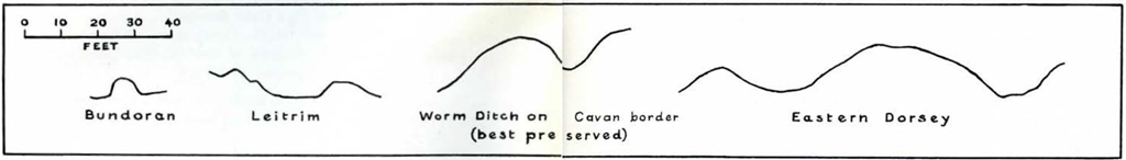
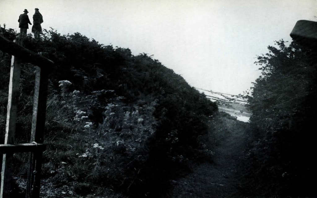
Before describing these earthworks, it may be well to point out that the dyke, which also goes under the names of the Dane’s Cast, the Black Pig’s Race, the Worm Ditch or Track, the Big Man’s Track and others, is a word covering both a ditch and the earthen rampart or wall which was built with the excavated earth. Together they form the fortification. As Mr. Patterson, curator of the Armagh Museum, and the authority on County Armagh, who was good enough to guide us for four clays, pointed out, where the dyke runs straight up the side of a hill as in some parts of the Scarva demesne and at the southern edge of Lough Shark the rampart was thrown up on both sides of the ditch. In the great majority of cases, however, the earthwork runs along the slope of a hill and here all the earth was thrown on the downhill side, the slope taking care of the uphill side so that an attacker would still have two sheer faces to surmount.
In describing its course it has been usual to mention the townlands through which it runs. As these average only about 100 acres apiece and usually have very long Celtic names, they are for the student and not for a general article such as this.
The northeastern earthwork is that mentioned beginning just east of Scarva, County Down. It is well described in the Ulster Journal of Archaeology, 1897, by Canon Lett under the title “The Great Wall of Ulidia” (Ulidia means eastern Ulster; Uladh used by Kane means all Ulster). It runs south taking advantage of lakes and bogs, and clinging to western slopes of the hills or running along the hillcrest on the Down Armagh border for about 9 miles of which half may have originally been dyke. It was doubtless connected with a 2-mile section in County Armagh southwest of Newry below Camlough Mountain. There is no reason to doubt that this was a continuous frontier fortification for the inhabitants of what is now Down.
Kane and others have tried to tic this fortification to his cast-west line, by way of the Dorsey, to the Worm Ditch west of Drum, a distance of some thirty miles, but there is no evidence of such a connection except one 100-yard fortification we examined south of Lake Ross and north of the Fane River on the Monaghan-Armagh border which may have once extended half a mile farther. As noted, the Scarva line faces west, the Dorsey and the rest face south. Were they one continuous line they should all face outwards from Ulidia. It is, of course, possible, as noted above, that the Scarva line was built by the Ulidians when they had been pushed into Down, after the destruction of Emain Macha, but this would still make the lines independent in time and place.
The Dorsey (Gate of Emain Macha) has been well described by Lett and others and there are good air photographs. It is a huge fortification in southern Armagh originally thrown across the natural pass through the mountains from south Ireland into Ulster. The east and west ramparts still stand 100 to 120 feet in cross section including the ditches, and up to 15 feet high from the bottom of the ditch on either side. Originally they were carried across a bog in the center of the pass (the only case on record) on hundreds of piles which have since been dug up. A secondary line averaging 600 yards to the north gives the whole the appearance of a great fortified camp though the secondary line faces in, not out.
With the permission of the North Ireland Ancient Monuments Advisory Commission, obtained through the assistance of Dr. Oliver Davies, formerly of Queens College and now with the West African Department of Antiquities, we attempted to dig up one of the piles to bring to the Museum for a Carbon 14 age determination. A whole row of these had been exposed in a 1938-9 excavation by Dr. Davies and we had their photographs, but in a day’s digging by Mr. Duffy, owner of the western fortifications, and a friend, with some help from us, found none. It is hoped that a piece will be found and sent on later. Dr. Rainey, who was making a quick survey of archaeological potentialities in Ireland, accompanied us on this day’s expedition.
We spent a day with Dr. Davies and Mr. Patterson on a line of fortifications some four miles to the east and south of Armagh and south of the Butterwater, which are locally known as the Dane’s Cast. They evidently formed some sort of inner line, possibly to protect Armagh from the Danes who sacked it many times in the ninth century, but Mr. Patterson believes they are much older as they are not mentioned in the chronicles. They, and the Dorsey, are the only ones we found not connected with existing county boundaries.
Sir Shane some years ago found a short earthwork just west of Middletown on the Armagh side of the Monaghan border which we examined.
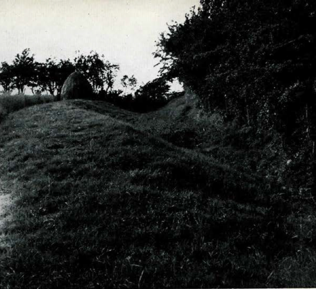
We come now to the Worm Ditch (it never seems to be called anything else in this locality) which is the central section of Kane’s theoretical east-west dyke. This we followed throughout its five-mile, 14-townland course, from 200 yards west of Laurel Hill School House in Cornapaste (the Hill of the Beast) in the extreme southwest corner of County Monaghan to the Bunnoe River west of Corrinshigo. The 1835 Ordnance Survey shows another 300 yards of it beyond that river, now levelled. It lies in Monaghan paralleling the Cavan border at an average distance of half a mile (never being so much as a mile from it). The single rampart, with a ditch behind it, faces Cavan and, as Kane points out, clings to the southerly slopes of the seven hills crossed. Between Laurel and Drumcore Laughs 400 yards of it actually form the existing border. Here it is undisturbed except by some one or two millennia of weathering and is 12-15 feet high from its foot, and from the bottom of the ditch at the rear, which is hollowed in a steep slope. Over the rest of its course, the Worm Ditch is often no higher than the ordinary banks enclosing fields but can be readily distinguished by its width and that of its ditch and every farmer knew it and took infinite trouble showing it to us. It is almost everywhere used as a boundary ditch for existing fields most of which are the same as they were in 1835. The Ordnance Survey shows l 1⁄2 of its original 3 1/2 miles (the rest of the 5 miles is lakes and bogs) levelled, but we found it in part of this area and 70 per cent of it remains. At the present eastern end it splits for 300 yards, each of the divisions running into the Bunnoe River some 200 yards apart. On the Phillips farm in Aghareagh West we found a 10-yard stretch that has a secondary bank 2-3 feet high forming a 4-foot ditch in front of the main rampart-apparently the only place this occurs, though Kane describes this outer ditch and rampart as typical.
I know how impossible it is to prove a negative, but I find no evidence that this 5-mile stretch extends either the 25 miles west to Lough Allen or Lough MacNean or the 25 miles east to the Dorsey. A suspected one-mile extension northwest of Drum proved to be facing the wrong way. We find no other lines or earthworks on the 1835 Ordnance Survey or the 1909 one though Kane points out that the surveyors were instructed to note all prehistoric works and many such are shown on both surveys as well as the earthworks wherever we found them except at Bundoran. Dr. O’Donovan rode herd on the 1835 survey, of which he was archaeologist, to locate the Dyke, just as Kane did on the 1909 one. Mr. P. G. O’Daly, a retired Monaghan County surveyor who spent a pleasant clay with us, knew of nothing else though he had a wide knowledge of, and interest in, all antiquities. Kane’s correspondents mention traditions but these are most general – “it went that-a way” – and Kane moved his line drastically northward between his 1909 paper and his 1917 one. We frequently heard that the embankment may not everywhere have been necessary as the missing parts may have been covered by impenetrable forests. This hardly seems likely for four-fifths of the purported route. The survey made 70 years before his correspondents wrote him seems better evidence than their traditions. Furthermore, if some 50 per cent of the Dane’s Cast and 70 per cent of the Worm Ditch is still visible, is it reasonable to assume that none of this 50- or 60-mile stretch would remain? O’Donovan said that the then existing part might last a century after 1835 and we met a postman who had “helped dig it down,” but very little has actually disappeared in the century.
Henry Murphy, Esq., Treasurer of the Clones Archaeological Society, found for us, a most interesting, previously undescribed “Black Pig’s Dyke,” remembering where his father had shown it to him, as that, when he was ten. Tt is on the Fermanagh (present Ulster) side of the Monaghan (Eire) border. The two are there separated by the 15-foot wide Finn River. It is less than half a mile north of the Great Northern Railway’s crossing of this border west of Clones, in a field belonging to Mr. Sherry. The dyke parallels the river at a distance of 40-60 feet, the 10-foot-high rampart facing it with an 8-foot-deep ditch behind it. It is over 50 feet wide, 30 feet from the west side of the ditch to the top of the rampart and 20 feet of forward slope. It faces into, not out of, Monaghan and therefore cannot be part of the same line as the Worm Ditch. We dug the embankment a little for piles without success though proving it to be 50 per cent glacial boulders. For a moment we thought we had found an ancient structure in the ditch, but it turned out to be an arms cache and a personal refuge of the Black and Tan days!
The term “facing” may be questioned. All the earthworks studied except those on the Leitrim Fermanagh border, hereafter described, were, when on a hillside and not running directly up the hill, basically composed of a rampart with the ditch uphill from it. Those of Emain Macha are also of this type. It seems unlikely that they would be built on an uphill slope and far more unlikely that a group would cross a stream to build them. (Two were found, as noted, on the bank of fairly large streams which would hardly have been crossed by defenders.) It therefore seems safe to assume that such ramparts were built by the people on the ditch side and that the wall “faced” the potential enemy.
The Shannon River where it empties into Lough Allen is known as the Valley of the Black Pig. The Ordnance Survey for some reason also noted it as Worm Ditch but I believe this was simply because the Worm Ditch in Monaghan was considered part of the dyke as noted above. The name appears to be purely due to the legend that the pig came out at the source of the Shannon and ran down its course. We traced the 8 miles from Lough MacNean south and found no earthworks and everyone told us there had never been any though the name was familiar. Kane could find no record of any. He was trying to correlate, eventually, three protohistoric boundaries of Ulster with legends such as this, significant Celtic place names, and existing earthworks. This quadruple correlation makes his text difficult to follow. It is evident that all writers on the subject since 1928 have been misled into thinking Kane had proved something which he certainly tried to prove, but which even a critical reading of his two papers shows he failed to prove. Disproving it, of course, is quite another matter.
Between Lough Melvin and Lough MacNean we found a dyke at two points at which the Ordnance Survey shows it, though, at a third, all trace is now gone. This is not on the Fermanagh (Ulster) side of the present boundary but on the Leitrim (Eire) side, facing Ulster to the northeast and following the northeast slopes. Furthermore it is basically a ditch. Earth was thrown to both sides even where the hillside is steep. It was never as massive a structure as the Worm Ditch, being only 30 feet in cross section. It looks just like the Grim’s (Woden’s) type of English dyke described by Major Godsal (1913) which he thinks was merely to mark a boundary clearly between two tribes, a line between mine and thine, and in no sense a fortification. From its position I am inclined to think it was built by the southerners (the O’Rourkes, a very helpful descendant of that clan told us, or some predecessors) to mark the line between them and the Maguires or their predecessors. It parallels the County River on the southwest and is half a mile to a mile from it and up to 100 feet above it. Unfortunately we could not trace its whole length owing to a driving rain, hillside bogs, and the fact that our car was not allowed to cross the Eire border from Fermanagh at this point. From the survey it still occupies a little over half the 7 miles between the two lakes and I have no doubt it was at one time continuous except for bogs.
Finally we come to the three miles between the Atlantic Ocean and Lough Melvin. We called at the same rectory from which Mr. Naylor, the rector, wrote about it in 1907. It is easy to understand how this letter, from the extreme west of the supposed course, would have made Kane think this theory was proved. By an amazing coincidence we discovered a visiting rector reading the description of the Black Pig’s Dyke in “In Search of Ulster” by Hayward, 1939! He had never previously heard of it. Kane’s influence with the Ordnance Survey evidently didn’t reach this far and their maps show nothing. However, 150 yards of a fine embankment (the ditch is filled in) parallel the old border on the northwest Donegal (former Ulster) side facing Leitrim (Eire). It is over four feet high in places and in others as much as 40 feet across due to the effects of erosion. The construction is so different from the Leitrim dyke south of Lough Melvin that I venture to suggest that they may not have been part of the same line of fortifications at all, especially since, as noted, this was clearly built by people on the north of the old and present boundary and the other apparently by people on the south.
To summarize our findings, the Black Pig’s Dyke of the literature is merely the old and, in fact, the recent Ulster border which has the remains of four or five lines of earthworks along it (depending on whether you separate Bundoran to Lough Melvin from Lough Melvin to Lough MacNean), and including also the Worm Ditch, the 1⁄2 mile south of Lake Ross and the Dorsey. These totalled less than 15 miles, 40 per cent of which are still clearly visible. None of the rest shows any traces of fortification or boundary ditches and it seems most unlikely that a continuous line ever existed. As has been pointed out, such isolated lines of earthworks are found along other former and present boundaries so it would be surprising if there were not some. It may well be said, “Just because they didn’t find it, doesn’t mean it was never there.” I can only repeat that two magnificently detailed Ordnance Surveys made 45 and 120 years ago, each under the eye of a Black Pig’s Dyke enthusiast, didn’t find it either and that the complete destruction of 25-30-mile stretches, when stretches of earthwork totalling 25 miles (I here include Scarva-Newry and the Armagh line) in the same sort of country are only half destroyed, seems statistically unlikely. A proposed aerial survey might find traces not visible on the ground and prove me wrong.
The name “Black Pig’s Dyke” is, I believe, merely one applied to many of the prehistoric earthworks to be found in northern Ireland unconnected with each other either on the ground or in time of construction. Kane mentions others along his first and second boundaries of Ulster, south of the third. These could not be studied in our three weeks but his 1917 paper shows that they, also, were not proven to have been continuous.
As to the origin of these earthworks, earlier writers feel that the parent was the Antonine Wall from Edinburgh to Glasgow. The Picts watched the Romans building it and must have been much impressed. Scotland and northern Ireland were closely connected through the ages, often being parts of the same country (Dalriada), and word would not be long in crossing the narrow waters and inspiring imitations. These ranged from boundary ditches to great earthwalls like the Dorsey and Worm Ditch. The latter could not have been permanently manned but would be a strong defensive line if the clan had notice of a raid and time to gather and would, in any case, make it difficult for raiders who might slip across it, to retreat, let alone get their stolen cattle across. Impressive as they are, and particularly as they must have been, the labor involved in their construction would seem well within the capabilities of the local population. I figure that 100 yards of ditch 10 feet deep and 20 feet wide at the top with a wall 10 feet high could be built even with wooden shovels in 600 man days (3 cubic yards moved per man per day) or by 20 men in a month. The Worm Ditch might take 300 men four months and the Scarva-Newry line possibly 1,000 men for an equal period. Kane’s dyke would have required some 10,000, probably beyond the capabilities of the Ulster tribes and surely something which would be recorded in the sagas.
In seven of the nine cases examined the earthworks run along existing county boundaries, an amazing proof of the stability of these through millennia.
Curiously enough the Antonine Wall seems not only to have had “children” in north Ireland and throughout southern England where the invading Angles used the idea, but also a “grandchild” the Danne werke across Jutland. This was built according to Godsal about 900 A.D. by Queen Thyra who had been an Anglo-Saxon princess. As Crawford has pointed out, a village on the Antonine wall was called Swine’s Dyke (Britannia Romana 1732). I believe that this name must have been a re-importation from Ireland. Some of the British dykes are pre-Roman and these Irish ones may also be, especially as the ditch is behind the wall while that of the Antonine wall is in front of it. Carbon 14 should settle that if we can get wood used in the construction.
We were generally told that such earthworks were confined to northern Ireland. However, on our way back to Cobh, we called on the well known author, Elizabeth Bowen. She told us that a similar line ran through the lands of Bowen’s Court in County Cork and was known as the “White Bull’s Dyke.” Her father told her it once stretched clear across southern Ireland. That had to be left for others to check. We can at least promise them a good time and a most interesting one.
Having started out with the idea of putting the Black Pig’s Dyke “on the map” as a line across Ireland, it is hard to have to suggest its removal from the maps on which it now appears, but that seems to me to be the only conclusion justified by the evidence.