Fairchild Aerial Surveys, Inc.
THE aerial archeological expedition to the Maya region, an announcement of which was published in the last number of the Bulletin, left Philadelphia on November 30th and returned on December 16th. The flights began and ended at Miami, Florida, the terminal point of the Pan-American Airways, one of whose airplanes, a twin-motored Sikorsky amphibian, was employed. This was in charge of two of the Pan-American’s capable pilots, Frank E. Ormsbee and William H. Carey, the latter of whom served also as radio operator. In addition to Mr. Percy C. Madeira, Jr., Dr. J. Alden Mason, and Mr. Gregory Mason, the party also included Mr. Robert A. Smith of the Fairchild Aerial Surveys.
A total of thirty-seven hours was spent in the air at an average speed of one hundred miles per hour, and of this about two thousand five hundred miles were over land most of which had never before been flown over. Two hundred and sixty excellent photographs were made, mainly from the air, as well as some motion pictures.
The expedition was favored with excellent weather and consequently, the visibility being good, geographical observations were made on an immense stretch of territory, the published maps of which are incorrect in many particulars. The advantages and disadvantages of the airplane in archeological work were demonstrated. For instance, the party was transported from Belize to Lake Yaxha in less than an hour, the journey by land requiring five days. A successful test was also made of the possibility of dropping supplies to a camp by parachute. On the other hand, it was decided that in this heavily forested region the airplane is of slight value in archeological exploration, except in perfectly flat territory where, by flying very low, archeological sites appear as mounds on the horizon.
On the afternoon of December 2nd, the party flew to Havana and the following morning to Cozumel Island off the east coast of Yucatan, traversing en route the northeast corner of the Yucatan Peninsula. That afternoon a flight was made in to the ruins of Coba, one of the lesser known but important Maya cities, and its location was determined with reasonable accuracy, it being about eight miles further south than heretofore recorded. The ancient causeways radiating from this city were plainly observed and photographed. The morning of December 4th, a flight was made southward along the Yucatan coast over the old Maya city of Tuluum [Plate II] as far south as the lakes of Muyil, thence north to Coba and east to Cozumel. On this trip a few small ruined buildings heretofore unreported were seen. In the afternoon the party flew from Cozumel to Merida, passing over Coba and attempting ineffectually to follow the causeway leading west. This part of Quintana Roo is perfectly flat and practically devoid of population. The ruins at Yaxuna were observed and their location accurately determined, and in the neighborhood of Valladolid a group of symmetrically placed mounds was observed, which may indicate a new archeological site. The party flew over the magnificent city of Chichen Itza and made some aerial photographs.
Fairchild Aerial Surveys, Inc.
The following day, December 5th, the flight led south over the ancient city of Uxmal and the other ruins of this formerly densely populated region, and then southeast nearly to Lake Bacalar. The region where the large lake of Chichankanab is located on the maps was flown over but the lake was not seen; it must be wrongly located. The party then proceeded westward to the city of Carmen, at the southern end of the Gulf of Mexico.
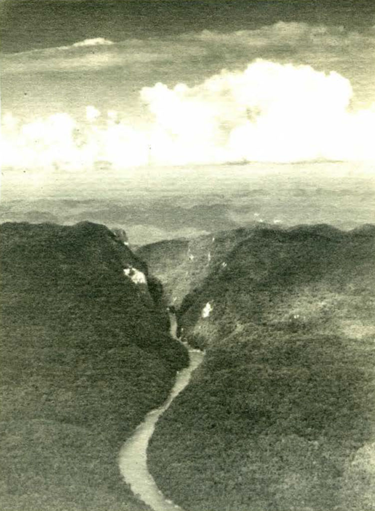
On December 6th, the valley of the great Usumacinta River was explored. The immense swampy delta was flown over and a landing made at the town of Tenosique, near the headwaters of navigation, covering in one hour a trip that may require a week of desultory river navigation. South of Tenosique the country becomes mountainous and precipitous. Neither Piedras Negras, where excavations will soon he started by the Museum, nor Yaxchilan were seen, although eager search was made for both and the airplane flew completely around the gorge surrounding the point where the latter city is located [Plate I]. From Yaxchilan, the course led west to Lake Petha and from there north over the rugged forested “desierto” hack to Carmen. Impending shortage of gasoline did not permit a short side trip to the famous ruins of Palenque. On this, as on all flights, important geographical information was secured.
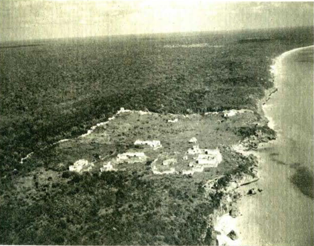
The following day saw the party in Belize, British Honduras, after a flight across the Yucatan Peninsula, a flight which consumed two and one half hours and would, at that time of the year, have required possibly a month of travel overland. On this flight two groups of ruins were seen in the northernmost part of the Department of Peten, Guatemala, probably the most inaccessible portion of the entire region. One of these consisted of four mounds on the largest of which a masonry temple towered high above the tops of the tallest trees [Plate III]. The other, at a few miles distance, consisted of three smaller mounds. These sites may have been reported by the native chicle gatherers, who are the only travelers through these dense forests, but they have never before been seen by archeologists. There is no landing place near them and their examination will entail a long and arduous journey by land.
Fairchild Aerial Surveys, Inc.
After a day’s rest in Belize, on December 9th the airplane transported the party to Lake Yaxha in Guatemala. Engaging men and mules here, they walked four hours westward to a small camp known as El Gallo, near which ruins were reported. The next two days were spent in a detailed examination of this site which, it was hoped, would prove to have been hitherto uninvestigated. Later examination of the literature has established, however, that it is the site known as San Clemente, on which several short reports have been published. Nevertheless a number of new features were discovered, and these, together with the many photographs and accurate notes taken here, will make a considerable contribution to archeological knowledge. On the fourth day the airplane returned from Belize and took the party back to that city.
The expedition closed with a long flight from Belize to Miami, on December 13th. During the first part of this last flight, the course was set over the eastern part of Quintana Roo and an attempt was made to find the ruins of Tsibanche, which were seen by Colonel Lindbergh on his flight across this region. They had been reported before this but only superficially examined. These ruins were not seen, but, close by the place where they were reported, other mounds were observed which may represent a new site. The geography of this region in the neighborhood of Lake Bacalar is very incorrectly depicted on the best maps, and it is certain that the airplane photographs taken from a considerable height here will be of great geographical value.
It is hoped that a careful study of the geographical and archeological notes, as well as of the air photographs, will throw considerable light on the question of the ancient Maya migrations and the habitability of certain regions, and will indicate which parts of the Maya region offer the most promise for future archeological investigations.
J.A.M.