For centuries men have dreamed of a “divining rod” or device that would indicate the presence of buried treasure in the earth as much as the X-ray reveals the presence of bones or foreign objects concealed in a living organism. Archaeologists have not been immune to this thought, but their interests are broader than the mere finding of treasure.
It is only recently, however, that this dream has emerged from the field of wishful thinking and that something is actually being done about it. The reason for this delay is that some big project, such as a war, where money is not a consideration, is necessary to bring about the sort of basic research required for the development of such tools.
The first practical attempt at such an application developed from the mine detector of World War II. As usual, the first civil use of metal detectors resulted from economic needs when commercial concerns made use of the principle to locate buried pipe lines and the like. It was not long before someone got the idea of using metal detectors in archaeology, but it must be admitted that treasure hunters rather than scientists were the most active in this regard. Fortunately, perhaps for the preservation of archaeological sites, this device responds better to iron than gold and did not prove very successful. Thus far, archaeologists have made little use of it because of its limited application.
Important contributions to archaeology have come out of atomic research. The radiocarbon method of dating prehistoric remains may prove to be the most significant contribution to archaeology during the past generation. Urey’s discovery that the ratio between the several isotopes of oxygen in the ancient skeletons of aquatic animals is directly proportional to the temperature of the water at the time these creatures were living, has given an accurate means of measuring temperature fluctuations in the sea over a period of one hundred million years. This and other techniques for prehistoric dating derived from atomic technology, such as the potassium-argon method and the thermoluminescence technique, may eventually make it possible to determine exact ages throughout the whole period of the Ice Age and to date more precisely pottery of the Neolithic Age. There is every reason to believe that the rapidly developing technology resulting from atomic research will provide other and still more revolutionary tools for archaeological research.
Most of us are beginning to realize that instruments resulting from electronic research may be just as important to the archaeology of the future. The two electronic devices now in use for underground exploration are the proton magnetometer and earth resistivity apparatus.
The proton magnetometer is a detector of very small changes in magnetic strength. It can detect not only buried iron deposits with obvious magnetism, but also buried kilns and soil disturbances. The kilns are detectable because the heating of the clay in past times has caused the small quantities of particles of inherent iron oxide to be aligned in one direction rather than at random, the resultant magnetism being larger than that of the surrounding earth. Some types of soil disturbances, especially ones associated with human occupations, are detectable because of the difference in the magnetic susceptibility of topsoil and sub-strata.
Other possibilities seem to exist with earth resistivity equipment. Electrical methods of exploring beneath the surface of the ground have been utilized for many years in geophysical prospecting for oil and minerals; also, more recently, by highway engineers to determine subsoil conditions prior to highway construction.
However, experimentation with these methods in archaeology has been rare. Dr. Paul Fejos of the Wenner-Gren Foundation recognized the possibilities of this technique in archaeology several years ago, but to the best of our knowledge only British and Italian archaeologists have seriously attempted to make a practical adaptation in archaeological excavation.
In Italy, Mr. C.M. Lerici has used electronic apparatus to obtain the precise location of Etruscan tombs. In England, for several years, archaeologists have adapted and improved resistivity equipment to the point where we can now be sure that electronic apparatus for underground explorations will become a standard tool of archaeology. The University Museum, which is carrying on major excavation at several different sites around the world, is now beginning a program of research and development in these new atomic and electronic techniques in collaboration with physicists and engineers. However, practical application depends upon considerable experimentation in the field. As a beginning, the Museum acquired two resistivity instruments, one manufactured in England and the other in the United States. Edwin Shook is experimenting with the British instrument at Tikal and the authors of this report have just completed an experiment with the American instrument at the site of Cerro de las Mesas in the state of Veracruz, Mexico; this work was sponsored jointly by the Smithsonian Institution and the University Museum.
Forty miles south of the city of Veracruz, the Bay of Alvarado penetrates deep into the coastal plain. With its source in the snows of Orizaba, the highest peak between Alaska and South America, the Rio Blanco flows into the bay. The region which it bisects is dotted with a great number of very large groups of earth mounds, marking centers of aboriginal population. Many of these mounds are so large that the present-day natives believe them to be natural hills. Judging from the enormous amount of labor that went into their construction, this region more than a thousand years ago was one of the most densely populated and highly civilized in the New World. Some of these structures were erected by the Olmec around 600 B.C., but the building of mounds reached its climax more than a thousand years later, during what is now called the Tajin period.
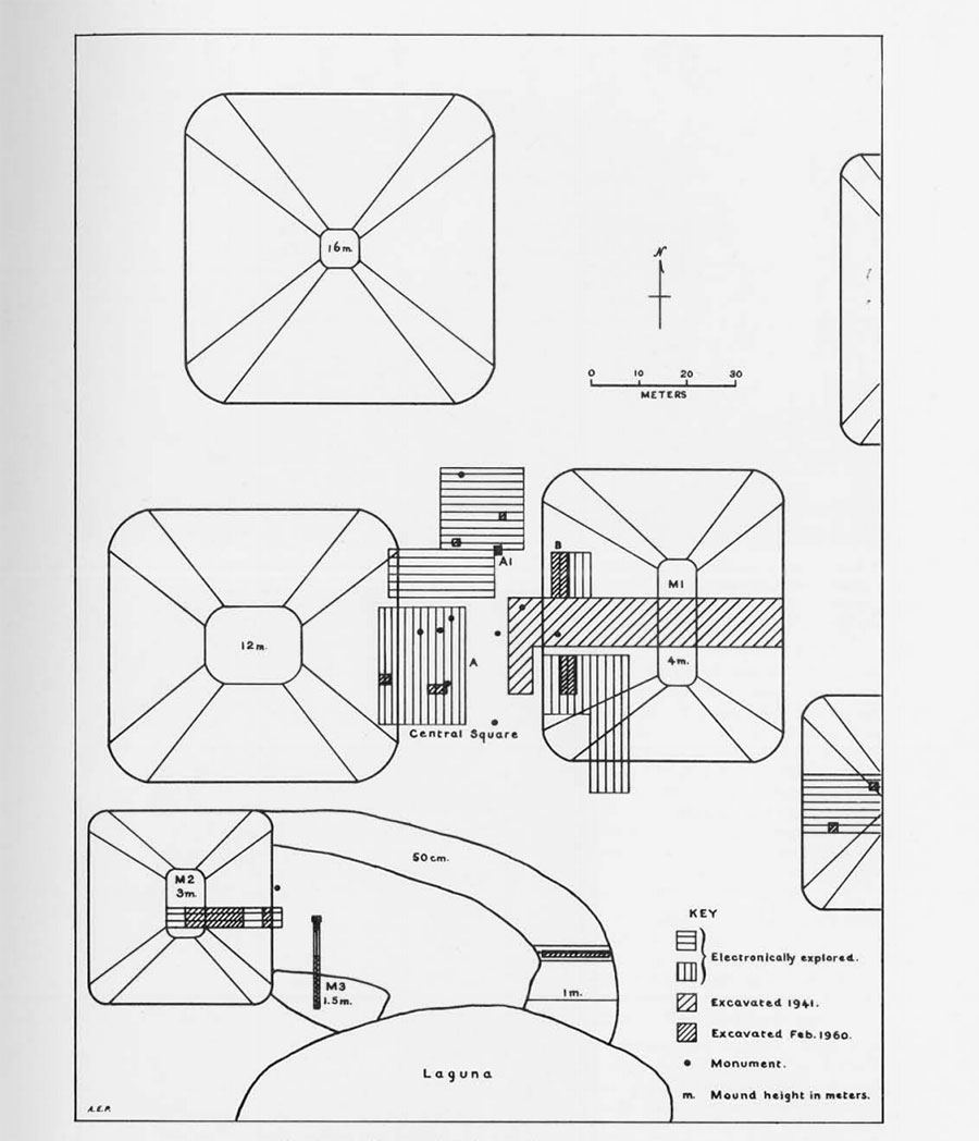
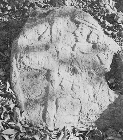
In the center of the Rio Blanco area is the site of Cerro de las Mesas, which we believe was the principal ceremonial center for this rich region. Here, more than adozen large mounds flank a series of more-or-less rectangular courts, one of which was framed by a now buried stucco coated clay wall. Within this Central Square were the major portion of twenty-five elaborately carved stone monuments.
Two of the stelae at Cerro de las Mesas bear dates in the same bar and dot system used by the Ancient Maya. These dates, using the Thompson correlation, are A.D. 466 and A.D. 533. When Dr. Stirling discovered these stones nineteen years ago, two were completely buried and the remainder only partially exposed.
At Cerro de las Mesas we were working under nearly ideal conditions for testing the machine. It is an area of fine sedimentary deposit where the ancient inhabitants had imported large stones for sculptured stelae and other monuments. Any large stones found in the soil are necessarily importations or cultural artifacts. As a result of Dr. Stirling’s previous work here, we knew a good deal about the nature of the deposits and the kinds of cultural remains which might be discovered with the resistivity apparatus.
The instrument we used is known as the Michimbo, the earth resistivity instrument manufactured by Associated Research Inc. in Chicago primarily for use by highway engineers for determining subsoil conditions prior to road construction. It is a rugged, transportable, twenty-five pound instrument for measuring the electrical conductance of the soil to a depth of thirty meters.
It is connected by four wires to four metal pins driven into the ground at equal intervals along a straight line. An alternating current is passed between the two outer pins and a voltage is thereby induced across the two inner pins giving a measure of the average electrical conductance of the soil between these two pins to a depth equal to the space between them. That is, if the pins are set one meter apart, the average conductance of the soil is measured from the surface to a depth of one meter between the two inner pins.
By changing the pin spacing, the average conductance of the soil can be measured to various depths. This feature permits the interpretation of subsurface layers of soil. For example, if the one-meter reading is subtracted from the two-meter reading, the average conductance of the layer of soil between one and two meters is obtained.
In practice, soil conductance is measured by balancing a galvanometer and reading a dial on the face of the instrument. If there is a difference of soil type, or soil moisture content, a wall, a ditch, or a stone mass between the pins, an anomalous voltage will be recorded.
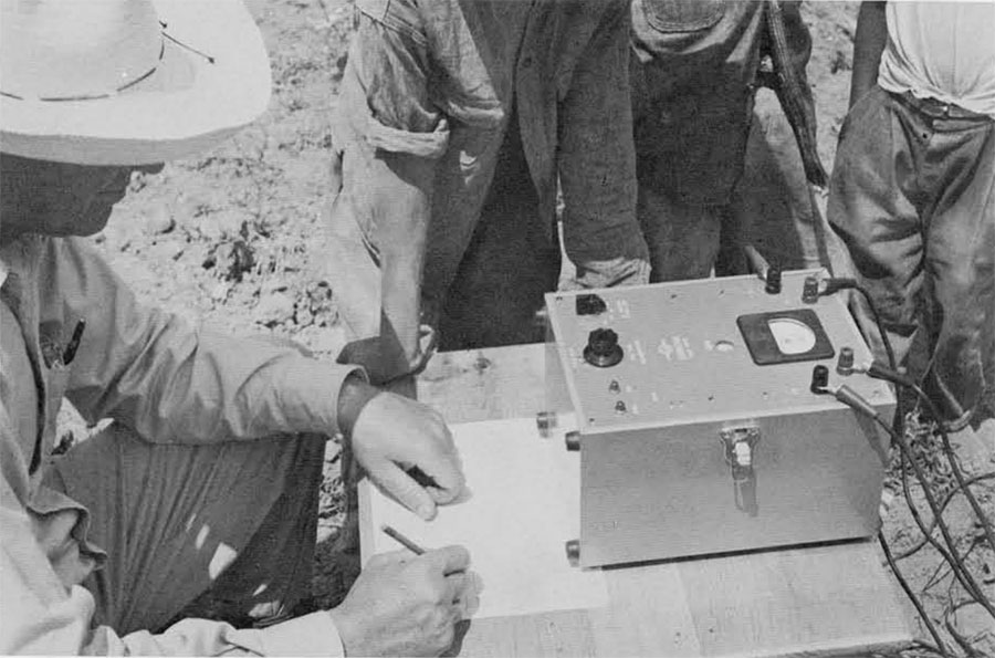
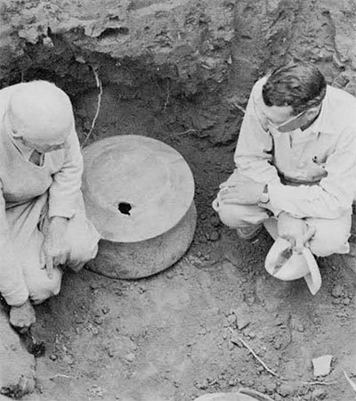
We were eager to get started with our experiments and went out to the site at our first opportunity. The stone monuments excavated by Stirling years ago had been largely reburied in the soil but most were partially visible. This gave us an ideal situation for a preliminary test. We knew that solid rock has nearly infinite resistance (almost no conductance) and this should register clearly on the machine.
By the time we had cleared the brush away from the monuments and were ready to start taking readings, a crowd of ten or fifteen natives had gathered. When Stirling worked here previously, the people had inquired, “Donde estan sus instrumentos?” At that time, Stirling had pointed to the picks and shovels and said, “There they are.” Now, nineteen years later, he had returned with an “instrument.” The natives stood around quietly as we moved the pins and recorded the figures from the dial. When we tried to explain that we were looking for buried stones they were puzzled. Why would anyone travel from the United States to look for stones? They had a better explanation. There is a treasure buried here and with our equipment we couldn’t miss it!
After taking readings both around and away from monuments, we soon learned that the mass of rock buried in the soil between the two central pins gave us a lower conductance reading, as it should, but this difference varied with the pin spacing. For example, one monument 92 cm. in height and 42 cm. in maximum diameter, almost completely buried in the earth, produced a resistance in the soil 31% greater than the soil adjoining the monument when our pins were spaced one meter apart. When our pins were spaced approximately two meters apart, the difference in conductivity was only 13%. A 20% change in the reading is significant.
Encouraged by the fact that under ideal conditions a mass of rock in the soil would give us a lower conductance reading on the instrument, we set about exploring the unexcavated area in what we termed the “Central Square” at Cerro de las Mesas in the hope of locating unknown monuments by making a series of earth conductance measurements in these unexcavated areas.
Our method was to stake out a field of exploration twenty or thirty meters in width and stretch a meter tape between two of the stakes. We then moved the pins down the line spacing them at one, two, one and two, or one, two, three-meter intervals, depending on the thoroughness we thought necessary. When one line was finished, we moved the tape and read a parallel line one or two meters away, the distance again depending on the completeness of information required.
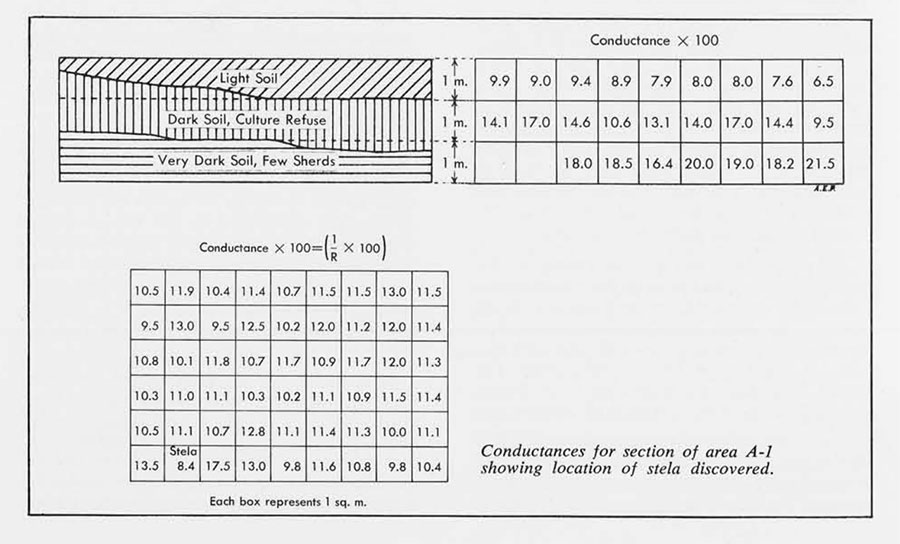
In this area (“A” on chart), we located five points of high resistance (low conductance) which seemed to indicate buried monuments. Four of the pits were just digging exercise for the workers, as they contained nothing except potshreds. We knew we had something at the fifth point (“A-1”) because we struck rock with one of the metal pins while driving it into the ground. This turned out to be a stone monument found by Stirling nineteen years ago and since reburied. Nevertheless, this stone does represent a “hit” in our experiment because the resistance in this section increased by some five points on the dial as compared to the surrounding area. The contrast in conductivity was great enough for us to have excavated there in any case.
After two weeks and many hundreds of measurements, our experiment in locating buried monuments was not really a conclusive proof of the method. We cannot be sure whether there are any additional buried monuments in the area or whether we have missed them in our recordings. We feel quite confident, however, that given a sufficient mass of stone and the optimum spacing of the metal pins, it is certainly possible to locate such artifacts in an area of this kind.

From this point on in our experiment we concentrated our explorations on the earth mounds. Our first trial was on Mound 1. We ran several lines of conductance measurements, cross-sectioning the mound with measurements at depths of one, two, and three meters. When the exploratory trench was dug, we realized at once that our instrument was accurately measuring differences in soil strata. Three different strata of soil were exposed in the mound, an upper level of loose dry soil which has obviously washed down the mound since it was occupied, a middle level filled with potshreds and other cultural refuse, and a third level of dark soil running down below three meters and containing few artifacts.
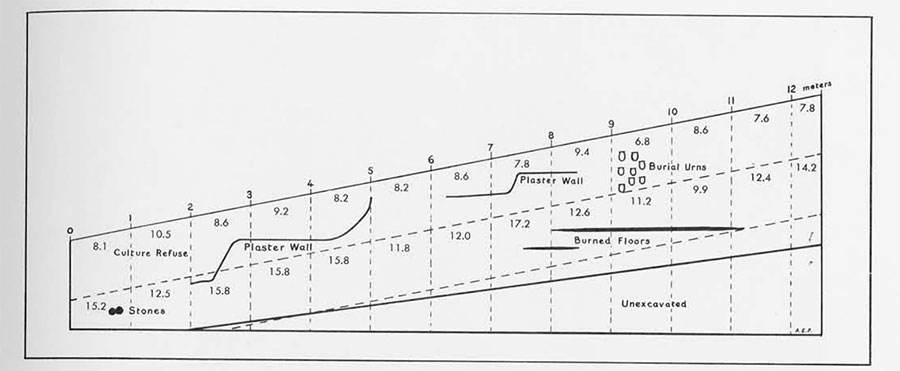
Our most successful trial occurred in Mound 2. We ran three long lines of conductance measurements from base to crest of the mound, reading each line at depths of one, two, three meters. In marking these measurements we noticed a certain regular variation between low and high conductance and jokingly commented that we must have hit some terraced structure beneath the surface. That is exactly what we found (see cross section of M-2). A group of fifteen burial urns concentrated in one section less than a meter deep gave us a reading 38% lower than the reading to the left and 26% lower than the reading to the right. This obviously marked an anomaly in the deposit. Lenses of fired earth discovered at the two-meter level also gave us a lower reading.
A small urn containing a collection of jade and other stone figures found in this cut was one meter out of line with our measurements. However, we suspect that because of its small mass it would not have shown in our readings.
As our work progressed and the empty trenches and pits continued to occur, our knowledge of the machine and what we were measuring kept increasing. For example, our first test excavation in the monument plaza produced nothing but a few potshreds. On examining the pit, we noticed that at this point the uniform mantle of light, dry soil was deeper than in other sections. It was clear that our low conductance reading was due to a deeper than normal deposit of the light dry soil.
In reading from base to crest of mounds, we also noticed that the conductance would go down as we went up. This indicates that the soil dries out faster at the top than at the base. Low conductances were also found where the soil was abnormally loose and dry, and around dead tree roots. Therefore, when utilizing this instrument in archaeology, one must always bear in mind that soil moisture content, soil structure, walls, masses of pottery, burned areas, gopher holes, compacted earth, and other subsurface anomalies all affect conductance measurements.
When one is looking for buried objects there is also the problem of their mass related to the volume of soil being measured. An object lying at two meters in depth must have considerable mass to affect the conductance between pins which are set more than two meters apart.
As in all experimental research, there were many times when we were completely puzzled. Why did some of the pits show nothing unusual but still gave us large changes in the readings? This enigma can be solved only by extensive field work with widespread digging to show the subsurface conditions for many different readings.

We have no doubt that the present instrument can be highly useful in almost any archaeological excavation as an aid in following out archaeological strata or subsurface constructions which have been identified by actual excavation. For example, suppose the digger is excavating a large cave deposit of prehistoric remains in which there is a culture-bearing stratum lying at a certain depth beneath the surface. The extension of sucj a stratum could be charted and any overburden quickly removed. Or suppose, as in many sites, the excavator wishes to chart the extension of a wall he has located. This could be followed and charted without excavation. The instrument in its present state is no “magic box,” but it can certainly be a valuable aid to the archaeologist when excavating a site.
For general exploratory work some sort of mobile apparatus would be highly desirable. The task of driving pins into the soil, taking measurements, and then moving the pins to the next setting is slow and time consuming when one is faced with the problem of exploring a large area. Working as rapidly as possible, we could make at most ninety readings an hour, thus, using one-meter intervals, covering ninety square meters. If a one- and a two-meter reading had been taken at each point, the area covered would have been only forty-five square meters. As a guide when a site is being excavated, this is satisfactory but in exploring a large area before excavation, this is slow.
We hope to develop an electrical sonic device to use in conjunction with the present instrument. This instrument would be more mobile and, we hope, be able to locate with precision buried objects of various sizes at different depths.
While the primary object of our work at Cerro de las Mesas was to test the resistivity equipment, nevertheless the results obtained were of interest from an archaeological standpoint. In addition to the structures and artifacts indicated by the machine, a considerable quantity of cultural material was found incidentally in the trenches. Since detailed reports on the previous work at the site have already been published, it is proposed to present here only some new information and a few of the more interesting finds.
As a result of the work in 1941, we suspected that human sacrifice was commonly practiced at Cerro de las Mesas. Our recent excavations have done much to confirm this.
Artifacts found in our mount trenches were in the form of offerings, not grave furniture. Nevertheless, in many of the trenches, scattered burials were found without accompanying materials as though they were themselves offerings. It is unlikely that regular burial could have been give a poor person in a choice location like a ceremonial mound. In 1941, many burials of common people were encountered in the deeply buried refuse deposits. These usually had some small objects with them and the skeletons were in recognizable graves. In the previous expedition only one burial of an important personage was found in a mound. In this case the body was accompanied by rich offerings in the form of jade, shell, stone, and elaborate pottery vessels, as well as a number of what appeared to be human sacrificial victims.


The deposit of fifteen covered burial urns which we found in Mound 2 evidently represented a mass sacrifice, since all had been deposited at one time. Each contained the remains of a child or adult and nothing more. This particular deposit was reminiscent of the similar mass of pottery vessels found at the site in 1941, each of which contained a severed human head.
In Mound 3 at the north edge of the laguna, we found a series of skeletons one above the other through a depth of four meters. These were in all probability sacrifices, as there were no accompanying artifacts.
One of our most interesting finds was in this same mound where we encountered a pipe line consisting of eleven telescoped pottery tubes. Each end had been cut through in ancient times, so we could not tell where the line began or ended. The north end headed directly for the base of one of the standing stelae, while the south end tilted sharply upward just before it was broken off. This resembles very much the “psychoducts” which were occasionally constructed in Middle America to give the spirit access to and from the tomb. If this is the explanation in this case, the tomb, probably in the middle of the plaza, had been destroyed by new construction while the site was still occupied.
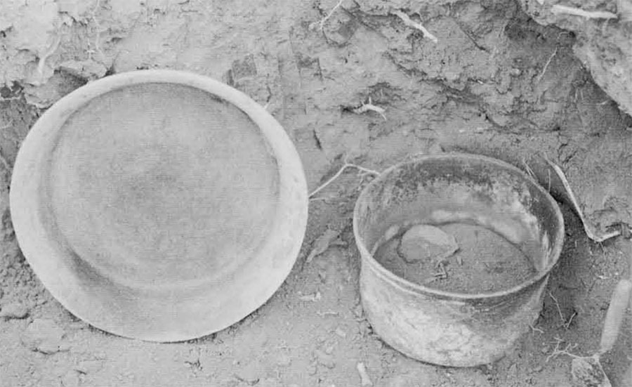
Perhaps our most important find was the offering encountered at a depth of one meter at the lower edge of Mound 2. The workmen first encountered two large, highly polished green-stone axes, set on end bits up. Just below these were three large fragments comprising half an ornate bossed incensario and a small olla which was covered by a small flat-bottomed bowl. On clearing the deposit and lifting the lid, it was seen that the olla was crammed full of carved stone objects. On top was the handsomely carved figure of a kneeling rabbit made from white limestone. The remaining objects consisted of ten stylized human figurines, nine carved from limestone and the tenth and smallest, of a bright green stone. There were also eight polished axes of jade and serpentine. The ten limestone figures are of particular interest, since they are Olmec in style. The little green figurine is done in an entirely different style and is ingeniously carved so that when inverted a different face is seen, the feet and legs becoming the headdress of the other figure. The reverse is also carved, so that a similar two faces can be seen.
The site of Cerro de las Mesas in general is post-Olmec, but we not suspect that it had its beginnings in late Olmec times and hence offers a good opportunity to study the transition from this earliest known Mexican civilization and the gradual development into the Classic period and beyond.
In the great jade cache discovered here by the 1941 expedition, there were included a number of typical Olmec jades which we felt might have been passed from hand to hand over many generations. In any event, mixed offerings of this type give ample ground for speculation. Offerings of jade or serpentine axes were a typical Olmec trait, as was the custom of placing them in the ground bit up. In this particular offering, the greenstone figure and the bossed incensario appear to be non-Olmec. Did the Olmec culture persist longer than we have thought, or were these long-treasured heirlooms?
During the course of our work, natives living within a radius of several miles daily brought us many specimens–figurines, pottery vessels and fragments, objects of stone, and the like. A point of much interest to us was the fact that the majority of these were of types not encountered in our excavations in the central group.
We think the central group, with its monument plaza, was the oldest in the region and therefore the most sacred. All of the material recovered from our trenches is early in type, while the trade objects from the neighboring mounds are not. It appears likely, therefore, that the numerous mound groups of the region represent a long period of development, many of them individually spanning a relatively short period of occupation.
The pottery from the early period, while often beautifully formed and decorated with geometric incised patterns or negative painting, is essentially monochrome: brown, red, black, or white. Following this, combinations of painted colors become more common, culminating in elaborate polychrome wares. This later development is well illustrated by our trade material. Pottery figurines of the early period are handmade while in the late periods molds were used in a sort of mass production.
In addition to fulfilling our main purpose of testing the electronic equipment, we feel that our excavations, though on a much smaller scale than those of 1941, have given us a better understanding of Cerro de las Mesas archaeology.