 The expedition in search of Sybaris and the later colony Thurii, directed by Prof. Froelich Rainey of the University Museum, have been conducted in collaboration with Dr. G. Foti, Superintendent of the Antiquities Department of Calabria and Engineer and Mrs. Enrico Mueller of Cassano Ionio. From these organizations, the following persons participated actively in the 1966.
From the Superintendency: Giuseppe Pellegriono, Gesuele Spinella.
From the University Museum: Fr. Rainey, Miss E.K. Ralph, Mrs. Curtis Jones, Miss Nancy Palmer, Oliver C. Colburn.
From Cassano Ionio: Enrico Mueller, G. Loise, Leone Nuncio.
From Rome: James Delmege.
From Varian Associates, Palo Alto, California: Douglas O’Brien, Frank Morrison.
To these persons and organizations we should like to express our gratitude. We also are indebted to Dr. Colin Kraay of Oxford University who helped with the Thurian issues and Dr. Michael Crawford of Cambridge University, who is currently doing detailed work on early Republican coinage, and also to Mr. Orville Bullitt of Philadelphia for his generous financial support.
After the destruction of Sybaris in 51- B.C. the survivors scattered to neighboring cities along the coast of the Ionian Sea. A couple of generations later they gathered enough strength to attempt to refound the city in 452 B.C. buit their old enemies the Crotoniates came up the coast and drove them out. An appeal was then sent to Sparta and Athens inviting new colonists to take part in founding a new city. Sparta was apparently not interested but Athens seized the invitation as a welcome opportunity to have a colony in Magna Grecia. The land of Sybaris was famous for its fertility and the old trade route across the Italian peninsula was suitable for the expanding Athenian commerce. Pericles, then at the height of his power in Athens, determined that the new colony would have an international aspect under Athenian guidance and proclaimed throughout the Peloponnesus that whoever wished might join in the venture. Achaea, Arcadia, and Elis responded and New Sybaris was founded.
The venture was short lived. Quarrels broke out between the colonists and eventually the remaining Sybarites and their descendants were driven out. The need for more men was pressing and the Athenian colonists appealed to Pericles again for help. Athens again launched the project, this time on a larger scale. Nothing was left to chance. The Oracle at Delphi was consulted by the seer and interpreter Lampon, who was the highest authority in Athens on all matters pertaining to religion. He obtained from the Delphic god an oracle touching the location of the new colony; it was to be planted where there would be “water to drink in good measure and bread to eat without measure.” A fresh group sailed in 443 B.C. seeking the answer to the oracle’s clue. The architect Hippodamus, who had laid out the port of Piraeus, is said to have sailed with them and designed the new city of Thurii. It had four streets on the long axis with three cross-streets, although this would seem to be a small number. The city was divided into twenty-five wards and the government was democratic. The site was “near the place of old Sybaris.” The coins were stamped with the head of Athena and an olive branch. Pottery makers went with the colonists and established the industry in South Italy. For all these reasons the city became the center of Athenian influence in Magna Grecia. Thurii flourished as did Sybaris before it and survived until after the second Punic War when Rome sent colonists in 194 B.C. to found Copia Thurii. Another century passed and the site was abandoned in 90 B.C., after which it vanished from the sight of man. No trace of a habitation level has been found throughout the centuries. In 1960 a long wall was discovered near the sea and the Applied Science Center of the University Museum was able, during the 1962 season, to trace it for a thousand meters, using electronic instruments. The upper courses were Roman and the lower courses were fourth-century Greek. This wall may have been associated with the port area of the city.
In May of 1963 the Applied Science Center under the direction of Dr. Froelich Rainey continued the Sybaris campaign. Miss Elizabeth K. Ralph, Assistant Director, was again in charge of the instruments used in the surveys, with the writer as Research Associate. This was a joint operation with the Lerici Foundation of Rome and Milan, with Ing. Carlo Lerici in charge of methods used in drilling operations.
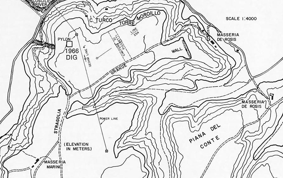
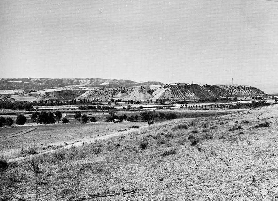
It was decided that the Museum group should run surveys in the foothills around the Plain of the Crati River while the Lerici drilling crew should continue operations near the sea. In early May we discovered the foundation of a heavy fortification wall on the eastern end of a plateau called Torre del Mordillo. The plateau lies 18 kilometers from the sea and is oriented on its long east-west axis along the Coscile River. From the eastern end one is afforded a view of the sea. The western end commands a view of the pass of the ancient trade route across the peninsula. It is a naturally fortified site which in troubled times would control the entire valley.
The plateau gets its name from the medieval “torre” or tower. These signal towers are spaced along the coast of Italy and were used to warn the inhabitants of impending invasions. The fortification wall separates the plateau proper from a tongue of land which slopes gently toward the sea. This is the least defensive portion of the site since all other sides have a steep pitch. The foundation is three meters wide, with three courses of headers and stretchers on top of which is a heavy course of rubble laid in place with no mortar. The structure of the upper courses is unknown.
At this time of the year the grain has not been harvested and therefore most of the area is inaccessible. We made an effort to trace the wall along the north side of the plateau with the proton magnetometer. Disturbances of the earth indicated there could have been a wall along the entire northern perimeter. We dug a test trench and while we failed to locate the wall at this time we did find enough pottery to indicate that this was a Greek fourth-third century habitation level. On the surface we found sherds of red-figured, back-painted, and plain ware, and indigenous Italic pottery. We were forced to suspend operations here until after the harvest the first week in June. At that time most of the grain had been cur north of the Grande or wagon road which runs the length of the plateau. A heavy mechanical plow was utilized for the first time in getting ready for the second planting. An immense quantity of building stones and pottery was brought up by the plow which laid down furrows 55 centimeters deep.
We used the proton magnetometer and the Geohm in the surveys to locate walls that were undisturbed by the plowing and turned over Grid #23 to the Italian Department of Antiquities for excavation. We ran further surveys on a line approximately parallel with the power line which traverses the plateau from northwest to southeast and also in an east to west direction from the tower to the middle of the site. Being restricted by our contract with the government to small test excavations, we dug trial trenches to check the readings of the instruments only. These trenches revealed a number of house walls in almost every portion of the plateau checked. The walls were constructed of rubble interposed with large stones and tufa blocks. In some cases carefully worked building blocks were incorporated along with re-used roof tiles, proving there must have been earlier buildings on or near the plateau.
Grid #23, excavated by Sig. G. Spinella of the Department of Antiquities, revealed a house with rubble foundations and probably upper courses of baked mud brick and wood construction, as was to be deduced from the large number of nails found. The roof was covered with proper pan and cover tiles and there were pipes for disposing of waste as well as for collecting water into a cistern. There was a terracotta tub for bathing and rooms for storage, weaving, and the other necessities of daily life. The interior walls had been covered with red paint over the plaster. The house had evidently collapsed under siege, as shown by the presence of two projectile balls in the house proper. At what date this disaster occurred we were unable to ascertain from the evidence collected by the Department of Antiquities. We did observe other projectile balls in various field corners where the farmers had gathered them along with stones and roof tiles over the years.
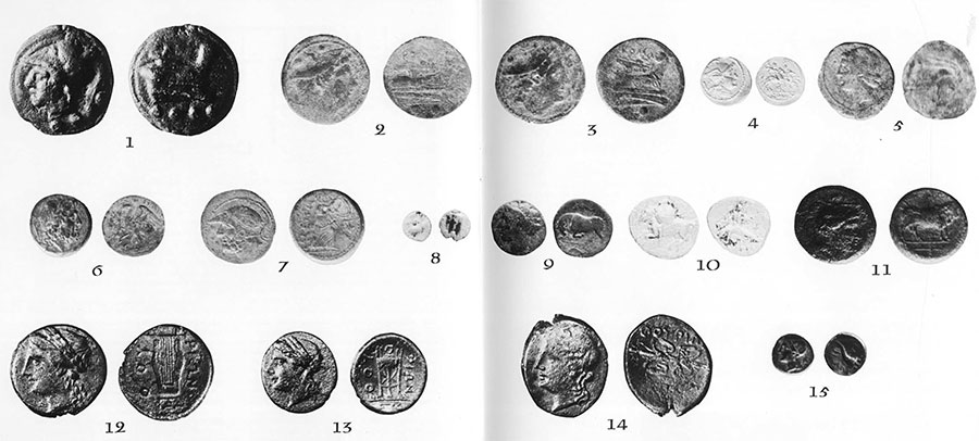
2, 3. Roman sxtantes. Obverse, Mercury. Reverse, prow of a ship. 218-216 B.C.
4. Roman quinarius. Obverse, Roma Reverse, Dioscuri. 216-200B.C.
5. Coin of Carthage, Obverse, Tanite head. Reverse, profile of hors’s head. 215-203 B.C.
6. Coin of Bruttium Obverse, Zeus. Reverse, eagle. After 282 B.C.
7. Coin of Bruttium. Obverse, Ares. Reverse, Bellona. 282-203 B.C.
8. Diobol of Croton. Obverse badly worn. Reverse, tripod. 5th century B.C.
9. Coin of Syracuse. Obverse, head of Agathocles. Reverse, butting bull. Late 4th century B.C.
10. Silver coin of Taranto. Obverse, horseman. Reverse Taras riding dolphin, 330 B.C.
11. Coin of Thurii. Obverse, Athena. Reverse, bull. 4th century B.C.
12. Coin of Thurii. Obverse, Athena. Reverse, lyre. Before 280 B.C.
13. Coin of Thurii. Obverse, Athena. Reverse, tripod. Before 280 B.C.
14. Coin of Thurii. Obverse, Athena. Reverse, thunderbolt. Before 280 B.C.
15. Coin of Thurii. Obverse, Apollo. Reverse, cornucopia. Late 3rd century B.C.
In 1964, Miss Ralph was able to trace a terracotta pipeline from a spring called Fonte Covello, some four kilometers to the south, leading to the ravine skirting the south side of the site. A pipeline would probably involve a syphon system to transverse the ravine. We could presume, therefore, that the settlement was large and important enough to afford a rather sophisticated system for securing water. During the 1964 season I again visited the site and found that the area along the wagon road had been plowed on the south side in preparation for planting. The visual evidence of sherds, tiles, and building stones pointed to more houses in this area and showed that most of the site was built up. The only sterile area we found in 1963 occurred in about the middle of a survey running from north to south, which we called the “cemetery di pichetti” because there were a large number of stakes driven into the ground during the survey.
The University Museum continued the Sybaris project in 1966 with Dr. Rainey as Director and Miss Ralph again in charge of the instruments. The author, assigned by Mrs. Curtis Jones and Miss Nancy Palmer, graduate students in classical archaeology, conducted an excavation on Torre del Mordillo for the purpose of obtaining a proper stratification and dating the site as closely as possible.
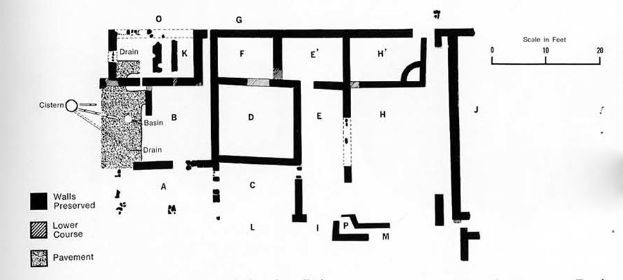
We selected an area close to the north power pylon which was within the survey of 1963 and which had not been disturbed by deep plowing. The power line had had an adverse effect on the instruments in 1963 and had made readings difficult. It seemed reasonable to assume, however, from this previous survey that there were additional buildings in this area. What developed was not a single dwelling but a complex with adjoining walls probably making up a block. Our unit shared a common wall on the south side with another house. There was still another house corner west of this common wall and this building had a wall running parallel to the south building. Because of the limitations of time and personnel, we confined our excavation to one group of rooms in this apparently extensive complex.
Again we found the construction to be rubble foundation walls with some pieces of re-used tile interposed. There were two carefully worked building blocks in one of the walls with the marks of the stonemason’s tools, again showing the presence of an earlier building of some magnitude whose blocks had been re-used in this present house. Most of the complex had been covered with a tiled roof and again the assumption is that the courses above the foundation were of mud brick and wood, covered with a proper roof. The collapsed roof tiles were found at an average depth of 35 centimeters. The tops of the foundation walls were, of course, at this level, which is the reason modern plowing has created such havoc with other dwellings on the site.
In the strata above the collapsed roof we found coins of early Roman mintage. One of the very early types is the Aes Grave (heavy bronze) with the head of Minerva on the obverse and the prow of a ship on the reverse. These heavy cast pieces were the first circular medium of exchange of the Romans and were the forerunners of all Roman coins. Their origin is unknown and though scholars differ as to the date they came into existence, 3000 B.C. should suffice.
They were minted until 218 B.C. Sextantes with the head of Mercury on the obverse and the prow of a ship on the reverse, may be dated 218-216 B.C. The first coins that were truly roman were issued during the second Punic War. The silver quinarius has Roma on the obverse and the Dioscuri (the heavenly twins Castor and Pollux) on the reverse; this may be datable to 210-200 B.C.
One key clue toward dating the destruction of the complex is a Carthaginian bronze coin which we found on top of the foundation wall between Areas C and D. It has a Tanite head o n the obverse and a horse’s head in profile on the reverse. One scholar has recently proclaimed this coinage to have been minted by the Carthaginians at Locri, south of Thurii, to finance Hannibal in the second Punic War and dates to 215-303. This would place the collapse of the house in the closing decades of the third century B.C.
We found nine coins of the Brettii (now called the Bruttii), a local people who aligned themselves with Hannibal against Rome. Dr. E.S.G. Robinson has recently (1964) placed their entire coinage in the period 215-303. This does not agree with our findings since we found only two above the tiles and the others in various levels below the tiles. Another scholar, Dr. Frederick Scheu, in 1961 placed the Brettian coinage much earlier (280 B.C.), which would be more in line with our classification. The Bretti had their capital at what is now modern Cosenza, some 50 kilometers south of Torre del Mordillo, after 280 B.C.
In the several strata below the collapsed roof tiles the coinage follows closely the dating of Thurii. There is a fifth century diobol of Croton; a diobol was a fraction of a drachma. There were fourth century coins of Syracuse, Taranto, and Thurii. The third century issues have the head of Apollo, which replaced that of Athena sometime between 280 and 270. The last Thurian issue may be the one with the cornucopia on the reverse. The cornucopia comes into use again in the coinage of Roman Copia Thurii.
Hannibal occupied Thurii from 214 to 207. By 207 Rome had regained Tarentum and Hannibal was forced to withdraw to the south. In 205, Locri was lost to him and in 203 he evacuated his headquarters near Croton and withdrew to Africa. The destruction of the house may be reasonable dated at 207 when the Romans reoccupied Thurii. In 194 B.C. Rome infused new blood into the weakened cities of south Italy by sending colonists.
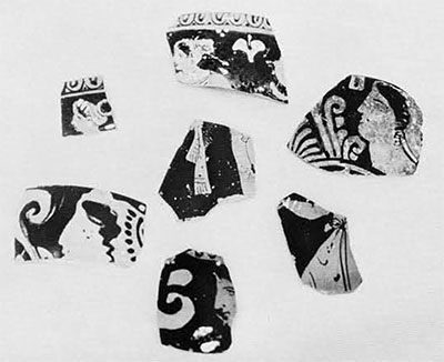
In the pottery sequence we found red-figured ware, black-painted ware, plain ware, and indigenous Italic ware along with a datable series of lamps. In the various levels below the tiles we found no imported ware of the time of Sybaris and neither were there Roman sherds above the tiles. Evidence of these occupation levels may, however, be elsewhere on the plateau.
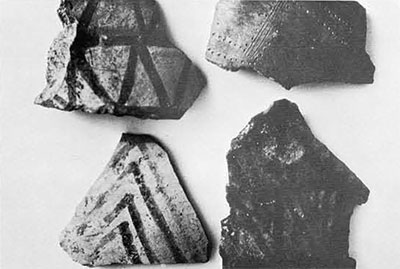
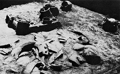
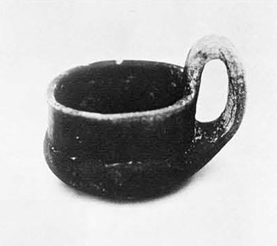
In Area F we established the lowest floor level at 45 centimeters. Just below this in the strata extending from 45 to 60 centimeters we found some sherds of black burnished ware as well as some reddish brown sherds of cups and bowls burnished inside and out. We also found sherds with a buff slip with bands of brown paint in geometric patterns, and some with impressed design. At 50 centimeters a burnt level appeared. This consisted of carbonized material and baked clay with the imprint of reeds, indicative of a fire during which a thatched roof had collapsed. In the level below, at 75 centimeters, we found a hearth-like structure under the carbonized material. There were a number of storage vessels, pots, and cups around the hearth, the majority of which are in excellent condition. We removed the Greek house wall between Areas F and E, as well as the wall between Areas D and F. This enlargement of the excavated area enabled us to unearth a very large collapsed storage pithos as well as three smaller storage jars. The cups and pots were hand thrown and were burnished inside and out. In some of the larger pieces of burnt clay we found traces of grass binder probably from the mud brick walls of this early house. In any event, some disaster overwhelmed the occupants and they were forced to leave without their eating, drinking, and storage utensils. We found no traces of tools except a small piece of obsidian. Many bones of pigs, sheep, and deer were at the floor level.
Examples of similar pottery can be seen at the museums at Matera and Reggio Calabria, where they are dated 1000 B.C. and 800 B.C. respectively. Our Carbon-14 dating of a sample of charcoal from the hearth. which is at a depth of 75 centimeters, is 989 B.C. and 58 years(5568 half life)
1078 B.C. and 60 years (5730 half life).
The culture represented by the Matera finds and our hearth is called the “Fossa Grave” culture, so named because of these people’s habit of burying their dead in fosse or trenches.
We collected another sample of charcoal at the -1.15 meter level in Area D, which represented another cooking fire, on which the Carbon-14 dating was 1235 B.C. and 58 years (5568 half life) 1331 B.C. and 60 years (5730 half life).
Near the end of the campaign we were able to trace the foundations of the city wall along the northern perimeter. It was not so massive as the wall protecting the eastern end of the city but was ample, being a rubble fill over two foundation courses and having a width of 2.3 meters.
One of the mysteries of Torre del Mordillo is that Italian archaeologists dug in the vicinity in the late nineteenth century and reported a “great necropolis,” since they found 239 graves at that time. There is nothing in their report to pinpoint the actual excavations. Neither is there any mention of a Greek habitation level, so they could not have been on our plateau proper.
At the close of the season, high altitude photographs were taken with a multiband aerial camera. As this article goes to press, we are eagerly awaiting the prints which we hope will show us the efficient way to continue work here, as they may well reveal the “great necropolis,” the plan of the Mordillo habitation area, and the outline of the enclosure wall and the gate area.