 In the 8th century B.C. the Greek people began a colonial expansion not unlike that of the British people more than 2000 years later. Southern Italy was to the Greeks something like North America was to the British. After a century of colonization most of the southern shore of Italy from Naples to Taranto was held by a number of independent Greek cities which carried on a rich trade with the Etruscans to the north and with the less civilized Italian people of the south. In wealth and population some of the western Greek cities soon surpassed those in the mother country. But by the 3rd century B.C. the Romans with their Italian allies were the dominant power in Italy and soon the Greek identity disappeared in a Roman state.
One of the most famous Greek cities of this era was Sybaris, an echo of which survives in our word ‘sybarite.’ Actually, the city became a symbol for wealth, luxury, and decadence and the substance of a moral judgment surviving in many legends and many languages. Sybaris was destroyed by the neighboring Greek city of Croton about 510 B.C., according to one legend, because the dancing horses of Sybaris deserted with their riders to the Crotoniates at the sound of trumpets played by the attackers. Legend also records that the Crotoniates directed a river over the defeated city and thus completely destroyed it.
Whatever the truth in these legends, the location of the ruins of Sybaris, unlike most of the other Greek ruins in South Italy, has remained an enigma during nearly a century of search. Historical sources are in general agreement that the city lay between two rivers, the Crathis and the Sybaris (now Crati and Coscile) on the Ionian Gulf between Metapontum and Croton. But today these rivers flow over a broad flat plain, facing the sea and surrounded by high mountains. On this plain, which was low-lying swampland from at least the 9th to the 20th century, the rivers had obviously changed course many times and there is no way of knowing from a surface examination where the river courses lay in the 6th century B.C.

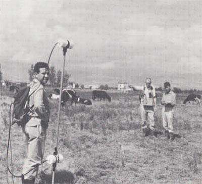
In 1961 the University Museum, in collaboration with the Lerici Foundation in Rome and the Superintendent of Antiquities in Reggio-Calabria, began a systematic search for the city ruins, utilizing new electronic equipment for underground exploration. Our objective was not only the location of the ruins, but an experiment in a new kind of archaeological reconnaissance which might lead to the development of more practical equipment for such surveys. The ruins could be anywhere in an area of about 125 square kilometers. This research resulted in the publication of a monograph called The Search for Sybaris, 1960-65. Thereafter, the University Museum and the Superintendent of Antiquities continued the exploration for an additional three years, during which we also carried out an experiment with a multi-band aerial camera, flown by the U.S. Air Force, and with infrared aerial film in the 7000 Angstrom range of the electro-magnetic band, flown by the Italian Air Force.
At the present time the Museum is concluded its search on the Sybaris plain with a final report on the last three years’ work. Summarizing that report I can now say that the ruins have been located on the Sybaris plain about two kilometers inland and on both banks of the present course of the Crati river extending in a north-south line for about three kilometers. In the southern section of this zone there are three levels of occupation, archaic Greek (Sybaris), 5th and 4th century Greek (Thurii), and Roman (Thurii Copiae). In the northern sector there is only one level and that one is archaic Greek.
During the several years of search we have excavated seven deep test cuts in the occupied zone generally known as the Parco del Cavallo area, and drilled many hundreds of holes with power-driven drills, so that we now have a fairly clear idea of the physical situation of ruins in this general area.
The archaic ruins lie anywhere from one to three meters below sea level and four to six meters below the present surface. A study of the drill and excavation records indicates that the archaic Greek city was built upon a line of shore dunes and at some time, probably in the late 6th century B.C. there was a sudden subsidence of the shoreward part of the plain which allowed the sea to rush in over the shore dunes and create a broad lagoon over a large part of the present plain. Today the ruins of Sybaris lie beneath a deep deposit of fine-grained gray-blue clay which could be formed only in still water. Above that is another thick layer of cultivated clay, or at least clay in which plants have grown. From this it is apparent that as the lagoon filled with sediment washed down from the mountains, natural or cultivated plants began to grow again producing the humus of the present surface level—the ‘terra vegetale’ in which the ruins of Roman villas are found at a depth of two to three meters.
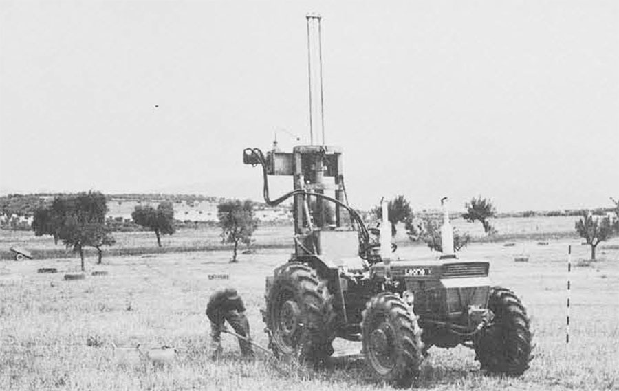
In the summer and fall of 1968 we employed a new type of tractor-mounted drill which has made it possible to probe the archaic level in the northern sector of the occupied zone and to delineate the actual form of stone walls and ruined buildings of the Sybaris period on the site. In this sector we can now recognize major building remains of the city. Toward the south, where archaic ruins are overbuilt by later Greek (Thurii) and Roman structures, however, we still have no way of detecting underlying archaic remains with the electronic instruments or drills, but test cuts and drills have recorded large numbers of pottery fragments of the Sybaris period lying in the substratum of sand below the clays.
On the plain during these past years we have developed a new type of magnetometer, in collaboration with Varian Associates, which will detect archaeological remains in this kind of terrain up to six meters in depth. Moreover, it can be operated much more rapidly than earlier types of magnetometer used for such surveys, so that the search of large areas like this becomes practical. It is unfortunate that a large par tof the Sybaris site has been overbuilt by later cities. If it were not for this, it would be possible with the new instruments to determine the plain of the original city, that is, if the remains are not too badly destroyed by the in-rushing sea, as we are now doing with the cesium magnetometer at Elis in Greece.
It is unfortunate that large-scale systematic excavations on the plain of Sybaris are, for all practical purposes, not possible. Not only do the ruins lie well below sea level so that they cannot be drained, but fresh water flowing through the substratum of sand is under pressure, sealed in by the dense clays above, and, when the clay is removed, the water under pressure from below rapidly floods any excavation. In addition, the water-saturated clay and humus levels tend to flow into any cut so that the walls of trenches or test pits will not stand. Our test cuts have been made with the greatest difficulty, utilizing many pumps and a drag-line.

The location of the ruins of Sybaris deeply buried on a sedimentary plain and below sea level because of the subsidence of the plain since the city was founded, certainly explains why Sybaris, unlike its neighbors, has not been found. It is a strange and fascinating coincidence that Helice, the mother city of Sybaris on the Gulf of Corinth, also disappeared beneath the sea. That city still remains to be discovered.
Many people representing the University Museum, the Antiquities Service in Reggio-Calabria, the Lerici Foundation, Varian Associates, the U.S. Air Force, the Italian Aerial Photographic Service, the Italian Air Force, and the U.S. Embassy in Rome have been involved in this experiment on the Sybaris plain. We hope that all of them have felt some of the excitement in a new approach to this kind of survey and satisfaction with the results. All of us owe much to Mr. Orville H. Bullitt of Philadelphia who has not only contributed to the major part of the cost of this venture, but has supplied the stimulation to keep it going for all of these years. His popular account of the search is to be published by Lippincott during the coming year.