The invitation to write an Expedition article on i was attractive, but reflection showed this to be an intractable task, due to the diversity of problems, issues, and types of sites being investigated by many workers. As an indication, about forty sites were excavated in Ireland in 1973 alone.
Fortunately, a representative survey of Irish archaeology is available, in Current Archaeology 22, September 1970—an issue devoted entirely to the subject. So I feel more free to concentrate upon three selected topics. These, I feel, are sufficiently interrelated to combine in a tolerably coherent article. All three also focus attention, however lightly, upon issues of potentially wide interest and importance that are particularly well reflected in Ireland.
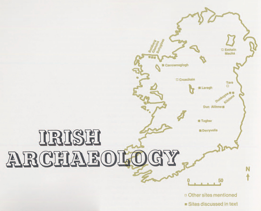
The general state of archaeology in Ireland is unusual in some ways, and a brief explanation is necessary to gain a fuller understanding of the research to be discussed here. In many parts of the world where archaeologists work good quality maps are lacking, for example. This is not the case in Ireland. Not only are there high quality maps prepared from about 1840 onwards, at scales from 25 inches to the mile downward and in successive and updated editions, but from the start of this work (the responsibility of the Ordinance Survey offices) ancient sites of all kinds were included on the maps, where recognized. In addition, notes on these sites were made, and updated periodically so that an organized body of basic information, essential to the conduct of much archaeological research, is available to any serious worker. Second, Ireland was and is a predominantly rural country, so there has been, so far, relatively little destruction of sites by industrial activity. Moreover, stock-raising is very important, particularly in the wetter western areas, and this emphasis on pasture has meant less damage from ploughing than is often the case in farming country.
On the ‘plus’ side, then, are the good basic documentation and a low level of destruction. On the other hand, the population density is low, so that there are proportionately few archaeologists to work on the tens of thousands of sites. Moreover, as we shall see, a large number of sites are very similar in appearance and all sites normally are covered with lush grass, if not more concealing vegetation. Thus it is not easy to classify sites, and normally impossible to make ‘surface collections’ of artifacts that may serve to provide rough estimates of their dating and function. Another natural phenomenon has buried sites completely, which is our first topic.
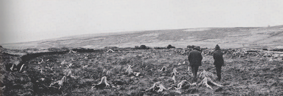
The blanket bog covers thousands of square miles, mainly in the west of Ireland. It is normally 5 to 8 feet deep, and is relatively recent, having formed during the past three to four millennia. Since human occupation of Ireland goes back at least six thousand years, there must be many earlier sites buried under this peat, quite invisible until the bog is cut away. But this is not so common as might be supposed, for two reasons. First, the areas of blanket bog naturally are unsuitable for any food production except rough grazing, so that the population is very sparse in these areas. In consequence, the rate of peat-cutting is very slow, and of course tends to be concentrated close to present-day settlements, which are mostly very small as well as scattered. So thousands of square miles of blanket bog have never been cut at all. Second, the cut ‘turves’ must be dried before they can be used as fuel. They are left on the bog surface after cutting to dry in the wind and sun before being carted off to be stacked close to the houses. The very lowest level of peat crumbles as it dries, so cannot be transported and stacked—thus is normally not cut at all. Only those sites that project through the lowest level of peat may be noticed. If they are noticed, they may not be recognized as anything artificial. If they are so recognized, they may not be brought to the attention of an archaeologist. So one can see that, until archaeologists appreciated this situation, and began deliberately to exploit it by seeking information from turf-cutters, few sites were even identified.
For the past few years, however, Dr. Michael Herity and Seamus Caulfield (both of the Department of Archaeology at University College, Dublin) have been actively seeking such sites. In several parts of western Ireland sites under the bog are now known. Most are lines of stones. These sound very uninteresting, and, across the usually short distance of a cutting in the bog, often do not appear to be clearly artificial at all. But, once recognized and investigated, they can be identified as deliberately constructed banks. Some could even be called built walls, though these are less usual. In several localities in Co. Mayo and Co. Sligo where research has concentrated so far, it can now be seen that there are considerable lengths of these banks, including junctions and even complete enclosures. They are, in short, field boundary banks and walls dating back to a time before the blanket bog began to form, when these localities were farmed landscapes.
Of course, we have accumulated much evidence for prehistoric farming in Europe. But, prior to the Iron Age, we have nothing approaching even a complete farm, let alone a whole landscape. This we need in order to attempt to answer major problems such as the size of arable land per settlement, the relationship of pasture to arable, the extent of adjacent woodlands, and the like.
The thinking archaeologist should dream of and pray for a complete prehistoric landscape, untouched and unharmed by later inhabitants. The circumstances in which this can happen are so unusual that the dream is seldom realized, but it is being realized, for once, in Co. Mayo today. Research can proceed only as fast as peat is cut down, so progress is necessarily slow. But enough has been accomplished already to suggest possibilities for economic and even social reconstruction on a scale hitherto unprecedented.
At Carrownaglogh several field-banks have been identified, evidently parts of quite an extensive system, at least. At the moment, the most interesting evidence from here is the identification of cultivation ridges, over which the peat began to form about 1000 B.C. The ridging of cultivated soils is common enough, but it is a technique of well-established and quite sophisticated agriculture. It may have one or more reasons—it can assist drainage, it can concentrate a thin topsoil into thicker strips, it can ensure a better turn-over of cultivated soil from year to year if the position of the ridges is shifted with each new season of ground preparation. At Carrownaglogh there is no indication as to whether the ground was ploughed or not, so perhaps soil preparation here was accomplished exclusively with the spade. This is the case on many smaller cultivated fields in Ireland today, especially where there are many stones, and results in the characteristic ridged ‘lazy beds.’ Whether formed by spade, or some other method, the cultivation ridges at Carrownaglogh are far and away the earliest ever discovered in Europe, except those at Belderg (below).
On the cliff-bound coast of north Mayo, three more sites have been investigated that throw additional light on early occupation and cultivation.
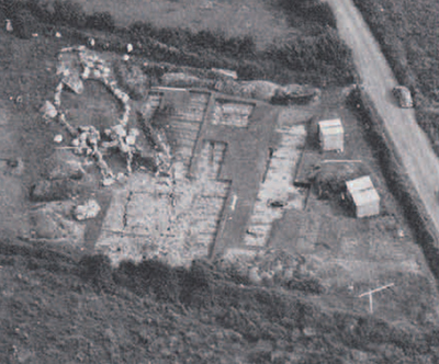
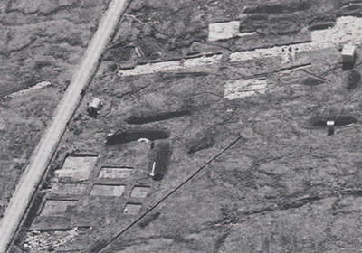
At Ballyglass, Sean 0 Nuallain, Archaeology Officer of the Ordnance Survey, excavated a ‘Court Cairn,’ a megalithic tomb of a type well known in western Ireland. Fig. 2 shows the stone tomb with its central oval-shaped ‘court,’ entered from the left, and from which access was gained to the two small burial chambers, one on each end of the court itself. The chambers were roofed originally and covered with a cairn of small stones. Of the surviving parts of the cairn, most had been removed before this picture was taken. And during the removal of the cairn, post-holes were found underneath one end (the ‘lower’ end in the photograph). Further excavation in this direction revealed the plan of a rectangular house, outlined by the trench in which the upright wall-timbers had stood originally. There are only a few houses of the Neolithic period known in the whole of Britain and Ireland, so this discovery was important. More important was the close relationship between the earlier house and the somewhat later tomb, since, of the tens of thousands of megalithic tombs in Europe, hardly any can be associated with houses. Admittedly at Ballyglass the house must have been at least partly dismantled before the tomb was constructed, but the material from each and structural details indicate that there was little time between the two events—both about 3000 B.C.
Very tantalizingly, a series of well-marked cultivation ridges stop just short of the Neolithic house and tomb—they can be seen to the right in the photograph of Bally-glass. I say ‘tantalizingly’ because, although the pattern suggests that the ridges stop short of the house and tomb because they were in the way of cultivation, the strati-graphic relation cannot be shown, and it is possible that much later `lazy-beds’ stopped on this line because of the remains of the tomb cairn. Since the Ballyglass site is several centuries earlier than Carrownaglogh and Belderg, the positive identification of Neolithic cultivation ridges there would have demonstrated a long and early prehistoric continuity of agricultural practice in this case.
A few miles along the coast west from Ballyglass lies the most extensive area of field-banks so far identified. This is labelled `Glenulra’ on the map, although parts of this field system lie outside Glenulra. The system of field-banks is by no means fully explored, and there are big gaps in the present plan, in areas where the bog has not been cut down far enough. But it seems from the partial plan that there may be a system of banks running inland and uphill from the coast, with smaller enclosures on the seaward, downhill, end of each strip thus enclosed, and larger areas uphill. At Glenulra a small oval stone enclosure was identified, and excavated. This structure is too large to have been roofed, and does not contain any certain but or house. But there are hearths and some post-holes, indicating a probable residential/domestic function. It is, therefore, similar to the better-known ‘normal’ ring-forts. Ring-forts are discussed further below, but it is appropriate to point out here that, of the various types of site included under this general term, the most usual is a farmstead enclosed within a circular or oval bank or wall. The bulk of those excavated appear to be of the first and earlier second millennia A.D., but there are a few earlier examples known, to which Glenulra might now be added. The Glenulra enclosure probably dates to about 3250 B.C.
A short distance away from the Glenulra oval structure lies a similar-looking site, as yet unexcavated. It seems possible that a pattern is emerging here, perhaps of individual farms separated by long stone banks, with cultivated plots close to the residences, and larger areas, maybe for grazing, uphill. There is even the suspicion that these ‘farms’ (if such they be) may turn out eventually to be so similar in size and layout as to suggest the possibility of a quite large-scale organized ‘colonization’ of this area, with standard ‘land-grant’ type holdings. At this stage, of course, such ideas are guesswork, and the possibilities for reconstructing certain elements of the social system of the period, by means of identifying individual farms, is even further removed from the evidence now available. But it can be seen that such possibilities exist, that such hypotheses can be formed, and that we are, therefore, faced with an unusual—not to say almost unique—situation and opportunity for reconstructing Neolithic societies in considerably greater detail and depth than is normally possible.
A little west from Glenulra again, we come to Belderg. The exposed field-banks here do not yet show any clear evidence of regular layout. The fields lie on a gentle slope between two patches of woodland—pine on the uphill, west, side and oak on the downhill, east side. This is graphically seen by the stumps of these trees, growing before the started to form but eventually swamped by it. and the stumps preserved by the same waterlogging action that inhibits bacterial decay. So here we have every possibility of seeing within a relatively limited area, a landscape of considerable variation and use around 1500 B.C., shortly before the bog began to form. In fact, a surprising detail is already apparent in this respect, for one of the ‘field walls,’ running approximately north-south, lies on the old ground surface at its northern end, but, farther south, runs over a thin layer of peat-bog, which thickens gradually farther south again. As the bank runs onto this thin ‘wedge’ of peat, it is supported at either side by a series of wooden stakes, driven through the peat into the firmer ground beneath. Clearly, the onset of peat formation was a slow and gradual process, and spread horizontally as well as growing vertically. And equally clearly, field-banks were constructed after peat had begun to form—presumably at least thin peat formation did not entirely prohibit the use of the land for some purpose, or enclosure would have been pointless.
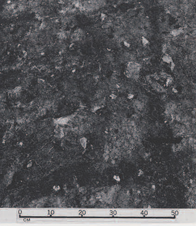
Fig. 4 shows a small portion of the area. Part of a circular stone but lies to the right of the road—another association of residential area with cultivation, as at Glenulra. Beyond the hut, and to its right, can be seen clearly the parallel lines of cultivation ridges. As at Carrownaglogh, these are on the surface of the old soil, immediately below the peat. When the first portion of this cultivated soil was removed, Mr. Caulfield, the excavator, was surprised and delighted to see rather faint, but unmistakable, traces of furrows (Fig. 5]. As is the case with other prehistoric and early historic plough furrows, only the bases of the furrows show, where the plough cut below the thickness of the darker topsoil into the lighter-colored subsoil beneath, so leaving darker lines scored in a paler subsoil.
As with nearly all prehistoric plough furrows, these ran in two directions, perpendicular to each other—clear evidence of ‘cross-ploughing’ which, with the light ‘scratch-plough’ of the time being unable to turn over the soil, was necessary to pulverize the topsoil sufficiently for planting. One set of furrows ran parallel to the ridges above them, indicating that both ploughing and ridging were part of the same cultivation process.
This discovery is without parallel in our admittedly scanty knowledge of European prehistoric and earlier historic agricultural techniques—the first time that both furrows and ridging have been found together at a date earlier than the Medieval period. As we have already noted, in connection with Carrownaglogh, evidence for prehistoric cultivation ridges is new, and may have been made there with a spade. The same might be true at Belderg, where the process could have been cross-ploughing first, followed by the spading of the pulverized topsoil into ridges. This cannot yet be determined, and even the most careful excavation over a large area might well not reveal the original process in that degree of detail. But to put this discovery into perspective: it has been held by most agricultural historians that ridged cultivation in Europe was first developed as a result of the ‘true’ plough. This implement, capable of turning the soil over properly, was and is employed often in such a manner that a series of furrows was ploughed in one direction, with a parallel series ploughed in the opposite direction, so that the second series lay toward the first. The two series, together, thus formed a shallow ‘ridge.’ The next strip of land would be similarly ploughed, to leave a depression between the two shallow ridges. The whole process results in the well-known ‘ridge-and-furrow’ pattern so characteristic of Medieval (and recent) cultivation in temperate Europe. Whatever the possible permutations of method by which it was achieved, it is now clear that ‘ridge-and-furrow’ cultivation goes back well into the second millennium B.C.
The sites discussed briefly above show clearly the enormous potential for further research under the blanket bogs of western Ireland, which cover a vast area, overgrown with peat slowly over a considerable period of time, so that ultimately there is every chance of unravelling not only the extent and variety of cultivation systems, land-holdings and settlement, but also the gradual contraction and modification of these Neolithic and Bronze Age farmlands before the remorseless slow advance of the peat.
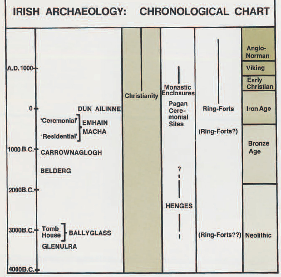
The amorphous category of ‘ring-forts’ is with little doubt the most numerous type of site in Ireland. At least 30,000 of these have been counted on the Ordnance Survey maps of Ireland. Many more doubtless were destroyed before the Ordnance Survey commenced work in the 1830’s. And at least some certainly were missed by the hard-working and dauntless, but not completely infallible, Ordnance Survey field-workers. The ‘ring-fort’ is, simply, a circular or oval enclosure bounded by a bank or wall. More rarely there may be two, or even three, or very occasionally four concentric banks. A characteristic ring-fort is about 30-50 yards across inside, with the enclosing bank inside a ditch. But many variations occur. Sometimes the bank is outside the ditch, sometimes there is no evident ditch—some of these are probably ‘henge monuments’ of the later Neolithic (see Hicks 1973). Sometimes the size is considerably larger than 30-50 yards diameter, occasionally many times that size. Of the few score that have been excavated, most appear to be farmsteads of the earlier historic period, although it is known that some were occupied as late as the seventeenth century A.D. Usually they are constructed of earth, but in many areas they may be made of stone—probably a variation due simply to local geology, but possibly reflecting function or date. Some larger ones on hilltops are called ‘hill-forts,’ with which we shall deal later. Some contain internal divisions. Some are documented as monastic enclosures of the earlier Christian period in Ireland. Many more are thought likely to have been monastic enclosures from the `Kil-‘ prefix that they may carry to their name; this is derived from meaning church, or ‘cella.’

So without further qualification, a ‘ring-fort’ may be of any period from Neolithic to post-Medieval, it may be secular, it may be ecclesiastical, it may be residential or military. It can be imagined, with such a profusion of these sites, and such relatively minor variations between them, that no clear classification has yet been seriously attempted, let alone concluded. And this is further hampered by the frequent lack of critical detail on the Ordnance Survey maps. For this, there are obvious explanations—mainly, the survey work was carried out by surveyors, not archaeologists, so that relatively minor points of detail were not noted; in addition, it seems likely that the draftsmen in transcribing the surveyors’ information onto the maps under preparation all too often reduced ‘ring-forts’ of varied shapes and sizes to more-or-less uniform stylized circles. One cannot seriously complain: the detailed and accurate survey of a whole country, over a period of a few short years, was a formidable undertaking, and we should be grateful, instead, that archaeological sites were marked at all rather than grumble that they were not always marked with extreme accuracy. But the result is that, in any serious attempt to evaluate and classify ‘ring-forts,’ one must visit each site to re-assess its dimensions and the details that it shows. Having visited several hundred of these sites [many heavily overgrown with thorn thickets), I can attest that this is slow work, But the variation is considerable, and there is every possibility of eventually determining several distinct groups.
Aerial photography is of great value in this type of work, and I illustrate this by a small selection from the large series taken by Leo Swan, a Dublin archaeologist. None of these sites is spectacular, but this emphasizes the everyday value of the method. Flying may seem an expensive way of conducting field survey, but it is in fact, economical. Light planes are not very expensive to rent, and far more country can be covered by air than on the ground. But, most importantly, new sites can be spotted from the air immeasurably more easily, and details of sites can be perceived far more clearly. In many cases the site cannot be seen at all at ground level, never mind its detail, of the five sites mentioned below, only one (Derryvella) was recorded prior to Mr. Swan’s photographic survey.
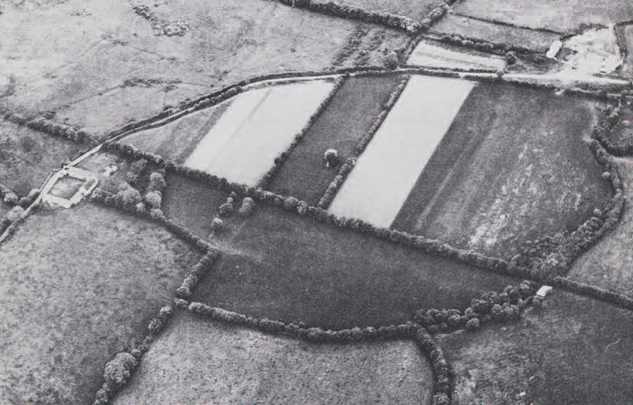
Fig. 6 shows Derryvella, in Co. Tipperary. The internal division is unmistakable—this type of division appears to be characteristic of numerous known monastic enclosures. Fig. 7 is a site named Laragh, in Co. Westmeath. Its surrounding bank and ditch are clearly visible as low relief from the air, but barely detectable amidst the rough vegetation on the ground. ‘Laragh’ means a site, or the site of a building. This is not specifically informative, but does indicate that recognition of this as a formerly occupied site must have continued in the locality for some time after its abandonment. Kilclone, Co. Meath (Fig. 8), is visible in two ways. One side shows in a curve of the modern road that follows the line of the bank around half of the site. Such twists and bends in roads and field boundaries often have no pattern when seen on the ground, but from the air it is often immediately apparent that they preserve the form of an ancient site. The other side of the site has been ploughed flat, but shows quite clearly in the differential growth of the field crop. This is quite invisible on the ground. The ‘Kil-‘ suffix, of course, suggests that this site might also have been a small early monastic enclosure, ‘-clone’ (cluain) means meadow.

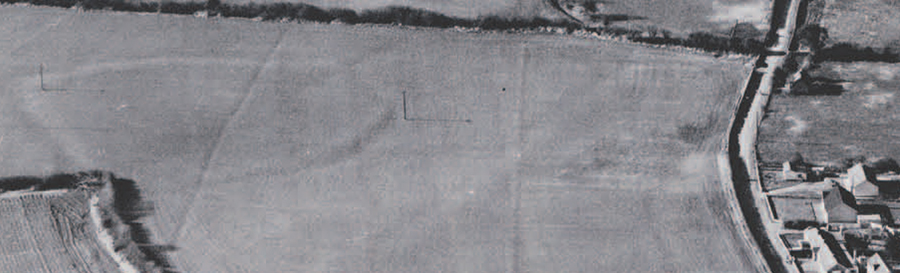
In Fig. 9 we have another example of an early site showing as a recognizable pattern in the present-day road and field boundaries. These combine to outline most of a large oval enclosure: only the upper right and upper and lower left arcs of the oval cannot be identified clearly. The townland name is Togher, which is not evidently applicable to the site, as it means ’causeway.’ But a second look at the photograph does show two short parallel lines of bushes just,across the road from the site, which are continued within the site, just above the right-angled field boundary cutting into the oval at the lower left; the right-hand line of the two is continued in the modern field boundary that continues to the bottom left of the photograph. Is this vestigial feature possibly the ’causeway’? If so, one cannot tell whether it was earlier or later than the site, or contemporary. But the aerial photograph could be used to pinpoint the location
of a small excavation that could determine this point, if desired. Finally, we came to Dunboyne (Fig. 10) discovered and photographed from the air very recently. The name suggests a fort—Dun Baeithin’—but further, unsolicited, evidence indicates otherwise. For shortly after discovering the site, Mr. Swan visited it on the ground, only to find that the field had been ploughed in the interval. Much ash and charcoal, and other indications of occupation, were revealed. But a hand-bell, of a type characteristically associated with early Irish monasteries, was turned up also. So here we evidently have yet another previously unknown ecclesiastical site of the Early Christian period.
All of these sites, seen from the air, are readily identifiable as of some antiquity, at least. Within limits, distinguishing features may be identified that suggest structural parallels with other sites of known period and use. As we have seen, the cautious use of place-name evidence may also assist. So, although none of these sites are spectacular, or apparently of any unusual importance when originally built and used, one can see how the continuous accumulation of such new information can lead, relatively cheaply and relatively rapidly, to very substantial quantities of hitherto unrecorded data that can serve to build up archaeological and even historical information from which patterns may be derived. Already we know considerably more of the distribution of the later Neolithic ‘henges’ than we did a few years ago. Some numbers of hitherto unknown forts have been identified. And, in particular, a number of earlier monastic/ecclesiastical centers, both larger and smaller, have been added to the previously known sites of this type.
Dun Ailinne
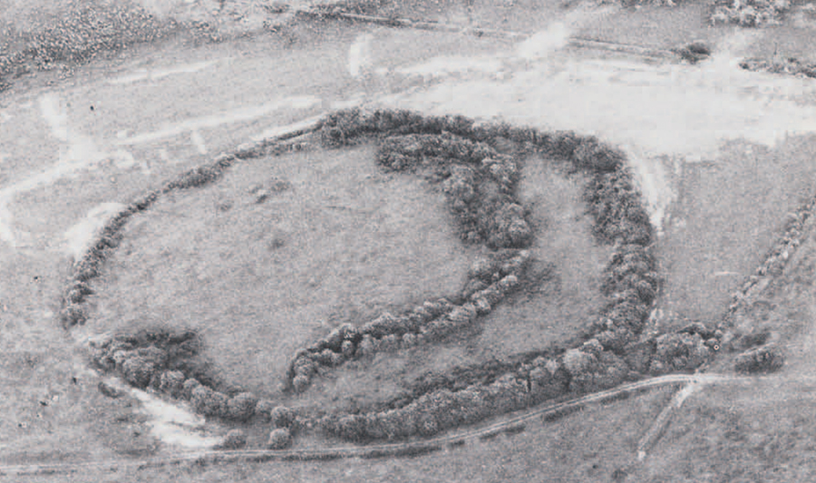
Dun Ailinne is one of the ‘hill-forts’ already mentioned in passing. This site is listed, in native Irish literature of the Early Christian period, as one of four sites of considerable importance before the coming of Christianity to Ireland (traditionally in A.D. 431, though there were very probably some Christians in Ireland before then). All four sites are contrasted with famous monasteries that flourished at the time of writing. The clear implication is that the four pre-Christian sites were of great significance in pagan religious terms. The other three sites are: Tara (Teamhair Breaga), supposedly the residence of the High Kings of Ireland; Navan Fort (Emhain Macha), the residence of King Conchobar of Ulster in the famous pre-Christian epic poem ‘Cattle Raid of Cooley’ (Tain Bo Cuailgne); and Rathcroghan (Cruachain), the traditional residence of the Kings of Connaught. Din Ailinne itself was the Leinster equivalent, it seems, of the other sites.
The location of ‘Dun Ailinne’ was uncertain until 1837 when John O’Donovan, a field officer of the Ordnance Survey, determined through a careful study of place-names that Knockaulin Hill, in Co. Kildare, must be identified with Dum Ailinne. ‘Knock’ (Cnoc) simply means ‘hill’ in Irish, ‘Dun’ means ‘forts,’ and ‘Ailinne’ and ‘aulin’ he recognized as variant forms of the same word, perhaps a personal name. Furthermore, Dun Ailinne was described as on, or close to, `Sliabh Cuillin’ (Cullen’s Hill or mountain), and Knockaulin Hill lies close to the small town of Kilcullen (Cill Cuillin, or Cullen’s Church). O’Donovan’s subsequent visit to the site clinched the identification: he was delighted to see that the hilltop was girded by a massive oval bank and ditch, clearly indicating a site of importance.
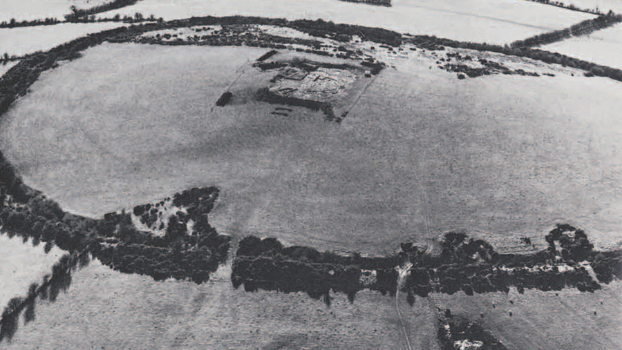
Our excavation began in 1968, at the invitation of the National Monuments Branch, Dublin. A short report of that first, exploratory, season was published in Expedition 11, No. 2, Winter 1969. We have continued work each year since, working mainly on an area of intensive occupation on the summit of the hill. Fig. 11 shows Min Ailinne from the air and the position of the present excavations in relation to the site as a whole; Fig. 12 shows a plan of the main excavated area at the conclusion of the 1973 season’s work. Without repeating a host of detail published elsewhere (see selected bibliography), we can confidently interpret this part of the site as the remains of a succession of circular timber structures, all of Iron Age date, and pre-dating the fifth century A.D. introduction of Christianity. Briefly, trench 512 represents the first Iron Age structure; trenches 60, 513 and 514, together with a southern ‘annexe,’ identify a second and far more extensive phase of construction; trenches 515 and 516, the inner ring of large post-holes (1-30), and the central structure (42), together comprise a third main phase. Subsequent to the dismantling of the phase 3 structure, Iron Age activities continued for a while in the form of periodic large fires accompanied by the roasting of considerable quantities of meat. Eventually, perhaps about the third century A.D., the site was abandoned.
 None of these structures, and none of the activities represented, can be interpreted as domestic/residential, nor is there any evidence for the working of metal, enamel, glass or other artifacts, which could be expected at an important residential site of this general period. The conclusion is that the whole Iron Age sequence of buildings and activities must be interpreted as ritual or ceremonial. Emhain Macha in Co. Armagh has also been excavated recently by Mr. Waterman of the Northern Ireland Archaeological Survey. The later phases of the Iron Age occupation there are remarkably similar in many respects to Dun Ailinne which, in view of the identification of both sites as ‘Royal Sites’ in the pagan Iron Age, seems more than coincidence. What is more, Emhain Macha is also on a low hill, encircled by a substantial bank and ditch. In both cases, the bank is outside (i.e. downhill from) the ditch. A short article on Emhain Macha (Navan Fort) can be found in Current Archaeology 22. The same type of large enclosure occurs at the Rath na Riogh, the largest of the several sites at Tara. Only very limited excavation has taken place there, though.
There are thousands of Iron Age hill-forts in Europe, and they have their banks inside (uphill from) the ditch—a reasonable arrangement for a fortification, one might well say. If the opposite arrangement does not form a plausible fortification, what is it? Here we return to the ‘henge monuments’ mentioned earlier. They are without doubt ‘ritual’ sites of the later Neolithic, and are restricted to Britain and Ireland. The ‘classic’ type of henge has a circular bank and ditch, with the bank outside the ditch. Many of these enclosures contain circular structures of wood, or of stone. There is over a millennium between the later ‘henges’ and the earlier stages of Emhain Macha or Din Ailinne, and precious few sites, during the intervening Bronze Age, that could serve to ‘bridge the gap.’ But the similarities between Neolithic henges and Iron Age ceremonial sites seem too many to write off as entirely coincidental, particularly since no plausible parallels to either can be found in continental Europe-They are both insular, and the possibility of insular continuity of tradition must be considered seriously.
In a wider context, this insular tradition can be seen in other elements of British and Irish archaeology when compared to continental Europe. In both islands, after an initial early Neolithic phase of rectangular houses (such as Ballyglass), a tradition of round houses becomes general, and persists in clear contrast to the rectangular house tradition of the continent. In Britain, this tradition persists until the Roman period; in Ireland, until the Early Christian period, when the first tiny churches introduce the alien rectangular ground-plan. In both islands, also, prehistoric and early historic settlement was generally the single farm, such as Glenulra and Belderg, or the small hamlet. On the continent, the most usual settlement during this time was the village. Other examples of an insular ‘culture’ within the culture area of Europe could be cited, but the point already emerges that there is a good case to be made for a definite continuity of cultural traditions from Neolithic to Iron Age, and indeed later in some parts.
It is within this context that we can see, more clearly still, the difficulties of distinguishing circular and oval sites in terms of chronology and function. But, on the other hand, one can see more clearly the potential benefits of studying an area within which a fairly stable and idiosyncratic tradition persisted over a very long period of time. This is particularly interesting since it is generally considered that the Celts entered Britain and Ireland not earlier than about 500 B.C. Even the minority of scholars would not place the earliest ‘proto-Celtic’ speakers in Britain or Ireland earlier than the very late Neolithic, certainly later than the initial development of the insular tradition of circular houses and sites. It seems that established regional traditions absorbed new peoples and new ideas rather than being replaced by new imported traditions. In this respect Ireland, more isolated from continental Europe even than Britain, and never conquered by Rome, appears to represent to a singular degree the retention of this insular tradition. This becomes particularly apparent when one considers that Irish society continued as essentially ‘tribal,’ without any real trend toward centralized political power and without any substantial trend towards urbanization, until these unfamiliar social modes were imposed from outside.
This retention of traditional forms is luminously illustrated by the earlier Irish monasteries. Christianity brought not only a new religion to Ireland, but also literacy. This new cultural mode resulted in a wildfire foundation of monasteries, which were important to Medieval Europe in materially assisting to preserve and transmit not only Christianity but also pagan Classical learning. In addition, the tradition of literacy rapidly led to the writing down, for the first time, of quantities of native Irish traditional history, myth and legend, of traditional law codes, and of both poetry and prose. These documents provide something highly unusual, if not unique: a native, internal, documentation over a considerable period of time, of a ‘tribal’ and nun-urban society. Returning finally to the monasteries, one can see from the documentary evidence that the Church, while remaining theologically orthodox, was transformed for a while in Ireland to a largely native type of organization. The early monasteries themselves reflect this native organization: the sites are circular or oval enclosures, and can only be regarded as Christian versions of either the traditional native secular ring-fort, or the traditional native pagan ceremonial site, such as Din Ailinne.