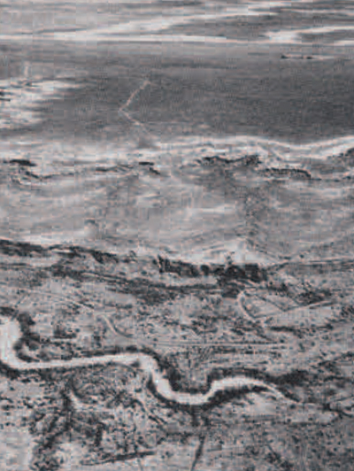
Aerial photography has rapidly become one of the major weapons in the arsenal of the archaeologist. Man has left marks and scars on his planet which are often invisible to the naked eye, but which can often be perceived and plotted through aerial photography. The constant use of a trail or human building activities will result in a change in the density of the earth at or just below the surface. This in turn will affect the drainage pattern and the fertility of the soil. Aerial photography after a rain will differentiate disturbed and undisturbed earth by color. Crops growing on buried roads and building foundations will be drier and a different color than crops growing atop subterranean ditches. By the same token, disturbed and undisturbed soil absorb varying quantities of heat. and infra-red aerial photography will furnish revealing patterns for the archaeologist.
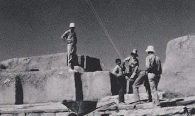
Once an excavation has begun, aerial photography is of still further use for the archaeologist. Low altitude balloon photography will furnish the archaeologist with an overall view of his site. This allows him better orientation and better overall control of his dig. Low altitude stereo photography will allow the archaeologist to plot architectural remains and reconstruct their plans without the necessity of surveying.
Over an underwater site, aerial photography diminishes the reflection and distortion of the water and enables the archaeologist to better select and survey his site.
Last year the University Museum aerial photo team visited and served six archaeological expeditions in five countries. traversing as many other countries en route, thus New Mexico in April, England in May, Lebanon in June. Iran in July, and Greece for a doubleheader in August. In April Bruce Bevan undertook the Chaco Canyon flights with Era Rainey giving our new multi-band camera its maiden flight. In May Eunice Whittlesey and I undertook multi-band flights in Epsom, Surrey with Mr. N. J. Hampton. Head of Air Photo Unit of the Royal Commission on Historical Monuments. June found the team reassembled in Lebanon for Jim Pritchard. Director of the University Museum’s excavations at Sarafand near ancient Sidon. Late June took us on to Hasanlu in northwestern Iran for Bob Dyson’s excavation.
With the Hasanlu coverage finished we drove west the length of Turkey to ship out of Izmir for two expeditions in Greece. The first was for the Greek Archaeological Service on a variety of land and water sites in and around the Argolic Gulf. The season finished with a water site survey at Sparta’s ancient seaport, Githeon in Laconia.
The content, purpose, and highlights of the six operations may be summarized briefly as follows.
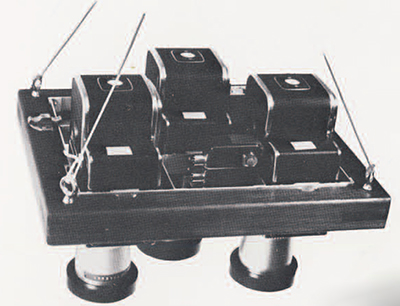
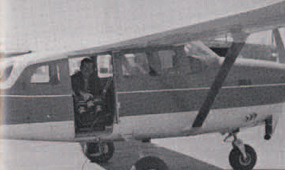
Chaco Canyon The objective was to discover traces of ancient trails leading across the plains to the Indian settlements on the canyon floor. Accordingly Bruce Bevan took many miles of oblique photos at modest altitudes from a small plane out of Albuquerque. He trained the multi-band camera upon the plains below, running black-and-white, color. and infra-red 70 mm. film through the three Hasselblad EL 500 cameras comprising the multi-band. Films have been processed in Albuquerque but interpretation of the results is still awaited. The Chaco Canyon flights offered the first practical operation of our multi-band camera designed and built in New York last winter. All went smoothly in Bruce Bevan’s hands. The same cannot be said for me later in England.
Epsom, Surrey The objectives here were primarily for us to learn from Mr. N. J. Hampton, a leader and innovator in aerial survey and discovery of archaeological sites. Practiced in spectral analysis of multi-band photography, Mr. Hampton had agreed to initiate me over sites already surveyed by him.
In each of three flights of two to three hours duration I crouched shivering at the open door of the plane training the multi-band upon scores of sites as Mr. Hampton came over them. He said that I had seen more archaeology on any one flight than most English archaeologists have seen in a lifetime. The meadows, ploughed but ten inches deep just short of the gravel base, offer abundant crop marks which respond actively to the changeable spring weather. This was a revelation to me having only read about it and seen unbelievable photos. Mr. Hampton flew about chasing Iron Age and Roman sites according to the shifting sunlight. We circled each, banking steeply for deep oblique and occasional vertical shots. A given meadow might show little or nothing on one day but a great deal the next, having been brought to life by a change in rainfall, wind, or sun.

Black-and-white, color and infra-red film were run as in New Mexico. The only difference was that I mixed up the filter combinations when loading the cameras late one night. Exposures and placement proved excellent but the value of the results for Mr. Hampton is questionable. A third flight carried black-and-white films, each being color filtered for additive color analysis. I believe this was a departure for Mr. Hampton. It certainly was for me. I did better on that flight. However, one Hasselblad tested “go” as we took off but ceased once we were over the first site. The cause was not found till several days later in Munich when an expert camera technician concluded the camera was “kaput.” and then discovered the failure of a tiny fuse. So. Mr. Hampton was left with but two rather than the three basic colors of the spectrum to work with. I owe him a return engagement to make good.
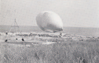
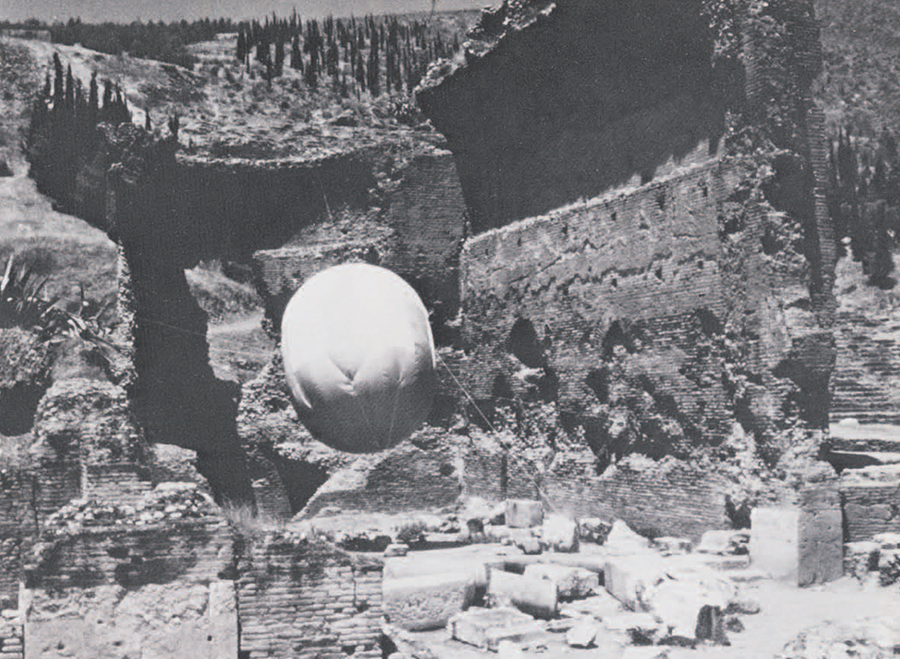
Lebanon Bruce Bevan had stopped in Greece, as a geologist, to assist Mike Jameson’s and Tom Jacobsen’s survey in the region of Porto Cheli and the Franchthi Cave. The Whittleseys drove all the gear from the Peugot’s winter quarters in Saltzburg to Venice, thence shipping to Beirut. We docked on May 30. The site of Sarafand is on the coast and exposed to every wind, with no chance for a sheltered balloon mooring. So we built a timber mooring mast the first day to hold the 16-foot balloon. This worked well although I had heretofore considered this type of mooring only for emergencies. Hydrogen inflation followed at dawn the next day. Two cameras were soon aloft running black-and-white and color in unison. The multitude of workmen gaped in blank amazement as the silver ovoid carried the strange-looking instruments aloft, radio antenna glistening in the early sunlight. Bruce Bevan and Tom McClellan managed the tether lines according to my directions and Eunice the radio. She responded to each shout of “take it” with care to avoid occasional camera spin. This went on for three mornings in the soft early light, covering not only the entire terrain from high up but coming down to as little as ten meters over each detail.
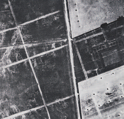
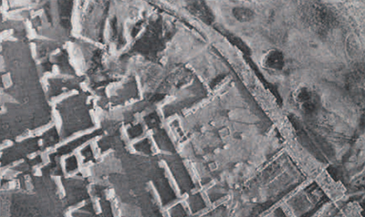
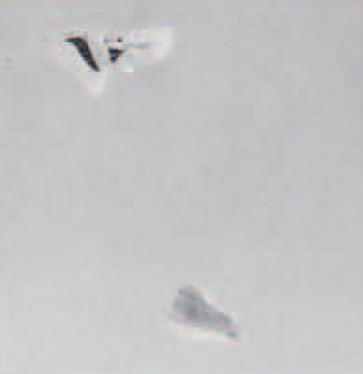
Field marks: Plan of Roman town of Calleva showing forum, streets, buildings.
Cause of marks: Buried walls and roads cause dry soil to reduce crop growth.
Crop: Spring barley: low visibility in harvested grass.
Substratum: gravel. Scale block size: Approximately 126 meters.
Film was developed each day for examination and guidance of the next day’s flight. Printing continued in our makeshift darkroom almost every afternoon. Color was developed in Beirut with much satisfaction. It was indeed a rich season, uncovering nearly a score of impressive Phoenician kilns and a temple entrance scattered with dedicatory offerings. Sarafand is the first Phoenician site to be excavated in Lebanon. We enjoyed Jim Pritchard’s smooth direction of this complex excavation and the enthusiasm of the assisting scholars. The laborers cheered each appearance of the balloon team, dubbing me Balloonji. Bruce Ibn Balloonji, and Eunice Balloonjiya. We stayed on some days after deflation to print and catalogue our work and photograph small objects and pottery for publication.
Hasanlu We set off across the Syrian desert late in June headed for Iran via Syria, Jordan and Iraq. We arrived on what we thought was schedule. but cables to and from Bob Dyson had missed their marks. We were greeted by him saying he had cabled us not to come because hydrogen could not be sent from Teheran 600 miles away. A short silence followed and we smiled back that we would break out the Jalbert Airfoil. We had it in a briefcase. The twenty-five meter high mound offered excellent wind exposure on the short occasions when the wind chose to blow. Lifting cameras by airfoil is a sporty game. True. we had practiced it last year against some dire emergency, but now we had to produce.
Bruce had a wind gauge. We would watch it anxiously for the eleven-mile breeze needed to establish the airfoil as a sky anchor. We could then hoist a radio-controlled one-shot-at-a-time Graflex XL camera. In ten days there were only three such occasions but many others when the wind failed or was too fickle to trust. Waiting was a pleasure for we could observe Dyson’s equally smooth operation on another University Museum dig unearthing spectacular finds. There was also time for Eunice to mend pottery. Bruce to be a geologist, and me to get a fever.
Three very successful and quite athletic airfoil flights ensued. two carrying black and white. another color film. A field team of five did it as follows. Dyson was commander, motioning for Bruce on the airfoil tether, and me on the camera lift line, to move about to bring the camera over his chosen targets. Once on target, he called “take it” to Eunice on the radio release. Upon her signal for “taken” I would lower the camera cautiously. Bruce maintaining the airfoil in flight. The camera shifts about, sometimes rather unpredictably, as it descends. A fast-running little boy, able to hurdle walls and never stumble, caught it with upraised arms at the critical moment. Eunice then reset the camera and radio release for another lift. The team soon became expert in getting over targets, coming down safely, and flying half a dozen shots on a wind of but short duration. Coverage was mostly at 100 meters taking in about 100 by 150 meters on a long format film using a wide-angle lens.
The airfoil is certainly the cheapest way to get a camera airborne. but it can lift you off your feet in a brisk wind. We have not yet dared fly an electric-driven Hasselblad that way, though it has been done by Dr. Jack Rinker of the U. S. Geologic Survey.
The Argolid From Hasanlu we drove via Lake Van, Trebazond, Ankara and Sardis to Izmir, making archaeological and museum stops. and thence shipped to Piraeus. A few meetings at the Greek Archaeological Service in Athens produced a positive reply to our offer to assist the Service on harbor surveys such as we had undertaken last summer at Old Epidauros. A permit was issued to cover land and water sites in the Argolic Gulf under the direction of the Ephor, Mrs. Deilaki. This promised another opportunity to work with Ch. Kritzas. Epimeletes for the Argolid, as we had at Epidauros, and generally to work with the Greek archaeologists. We reached Nauplia late in July. Mrs. Deilaki soon had us established with a fine mooring site in the Boy Scouts’ yard below our hotel balcony. An inflated hydrogen balloon must be watched and kept safe from visitors, both for its sake and theirs.
We had several objectives—to survey the waters around the little Bourzi Castle island opposite Nauplia for evidence of submerged walls: to survey the bay at Karathona and another on Romvi Island off Tolon for archaeological evidence needing protection in the event of shore developments; a water survey of the sea off the fortress of Asaine near Tolon and of the ancient shipyard site opposite Tolon; a survey for submerged walls rumored in the gulf between Bourzi Castle and Lerna. At Argos. across the gulf from Nauplia. there were also current land excavations by Mrs. Deilaki and Mr. Kritzas to be covered, and anything we could manage over the nearby Agora, Roman Baths. Greek Theatre, and the current French excavation of the sanctuary of Aphrodite would be welcome. Finally, of major importance were Mrs. Deilaki’s Mycenaean tomb excavations adjoining the Evangelistria monastery at the outskirts of Nauplia.
The weather was so great for extended balloon flights that we fulfilled the entire program, rising every morning at dawn for either a water or land flight. One week finished the flying with film development each day to assure ourselves that we had been successful. The first flight around Bourzi Castle yielded scrappy coverage which was made good in a later flight with both black-and-white and color. The Tolon and Karathona series was done in one long, calm morning, cruising some ten kilometers with the balloon held 1000 feet or so over our boat. We never had it better. Mrs. Deilaki directed.
The Argos flights took two days of intense effort assisted by Ch. Kritzas’ abundant energy. Shoe-horning a sixteen-foot inflated balloon through a Greek town festooned with overhead wires in narrow streets overhung by balconies and plied by large trucks was an adventure. Wind came up mid-morning of the first day after a series of high shots had been taken. We moored in the Roman Baths, posting guards till our return next morning. Good weather favored completion and we were able to throw in the Apollo sanctuary on the Aspis for good measure. We came upon it unawares, to Kritzas delight, while maneuvering to reach Mrs. Deilaki’s excavations. We missed her major dig at Argos. finding it impossible to reach through a maze of narrow streets. This would have required deflation to get there and reinflation at the site. at the sacrifice of our limited supply of the precious hydrogen. It can await our new hot-air system next year. Having aspirations for the Legion d’Honneur I took especial pains over the work of the French archaeologists. Ch. Kritzas has since presented them with an enlarged print from a photo taken 100 meters directly over the Aphrodite sanctuary excavation. This came as a surprise to them.
The final flight, left till last as it presented no logistic problems, was perhaps most urgent, namely Mrs. Deilaki’s Mycenaean tombs. These were currently yielding magnificent intact pottery and skeletons. We covered the site thoroughly with 24 exposures within an hour. There was comprehensive coverage up to 500 meters, thence down to as little as ten meters over individual tombs into which the camera could look straight down.
A week of printing, cataloguing. and binding followed. The German Institute’s splendid darkroom had been offered us once more. As we turned in the completed work at the museum office we were glad to hear of other areas the Ephor had in mind for next year. Work with the energetic Greek archaeologists had been a rewarding experience. Having less supporting staff, especially in associated disciplines, than the foreign schools have. the Greeks make up for it by discipline and long hours.
Githeon Our appointment to join Dr. Niki Skoufopoulos’ water survey was August 9. We were there and flying high over Githeon the next day, having presented our credentials to the Ephor at Sparta on our way down from Nauplia. The expedition was put up in an unfinished resort upon a bluff some two miles from Githeon. Under the bluff was a copious waterside cave which solved the mooring problem. Never was the balloon safer from wind and visitors or so well protected from the sun.
The first flight was on foot along the shore, moving cautiously into Githeon’s busy harbor. Expansion of the town by harbor filling, not uncommon in Greece, had covered much archaeological material back in the late twenties. More is being covered today by harbor fill for a public stadium. From the first flight we made a mosaic of prints taking in over a kilometer of shore line at relatively low elevation, We had much more to do, including high comprehensive coverage especially for mapping. However, the “meltemi season” with its ubiquitous gusty winds was upon us next morning, to hold for ten days. Each dawn was a disappointment. Printing and mapping occupied some of our time but there was also time for visits to the Mani peninsula.
Seemingly defeated by the “meltemi” we finally had to set a date for departure. This was Poseidon’s opportunity to embarrass us by a perfect day once we had gone. So we loaded the Peugot ostentatiously but kept the inflated balloon hidden overnight in the cave. It worked. We foxed him as Odysseus would have. There was a glassy calm next morning and we flew offshore for a good three hours, covering three kilometers of shore line at high altitudes. Our developed films were left with “Chip” Vincent to print for immediate use. Niki later reported that her surveyors filled in their maps from the results of the coverage taken that day.
Dr. Harold E. Edgerton of underwater sonar fame was on the survey. He explored the sea bottom at some distance and depth, for there had been seismic disturbance at Githeon resulting in considerable subsidence. “Doc” is a favorite on many expeditions. He deplores fancy instrumentation ready-made. He refers to his own as junk put together in his M.I.T. lab to teach the young. Both of us put on demonstrations with talks to those interested. A flight of the airfoil particularly delighted Doc Edgerton.
So the season closed having advanced our techniques considerably. The next season is already nearly fully programmed in Greece. A new system will have been developed and field tested meanwhile. It will be an unmanned, tethered hot-air balloon to carry the Multi-Band. more mobile and economical than the hydrogen balloon system. Designed for our requirements by Don Piccard, it has already been ordered from the West Coast.
-

- When flown by balloon, the multi-band cameras are put in a light aluminum frame and are suspended beneath the balloon. The shutter
-

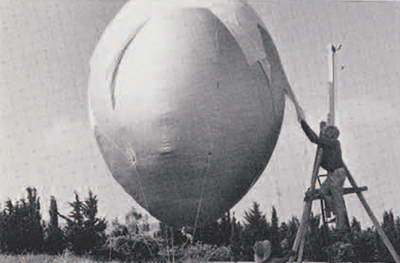
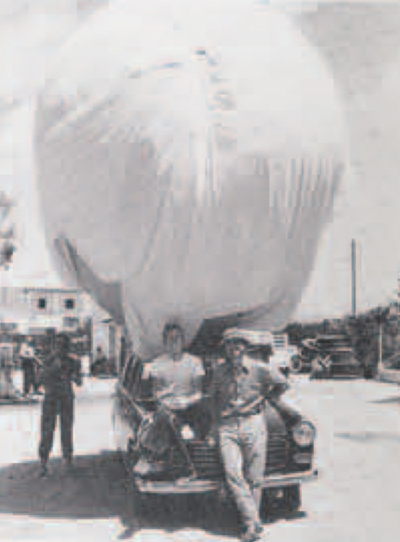
- Mooring the balloon in a sea cave.
-

- Start of a morning’s ballooning.
-

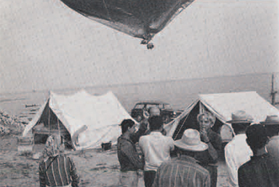
- Ballooning at Githeon.