 Undisturbed by modern plowing, the remains of ancient fields are still common on the chalk downlands of southern England. Where these remains are substantial enough, they can be studied not only for the history of the landscape, but also to reconstruct the economies of the societies that made them. To do so, however, we need to know when the land was divided up, how long the fields remained in use, and if possible, how they were farmed.
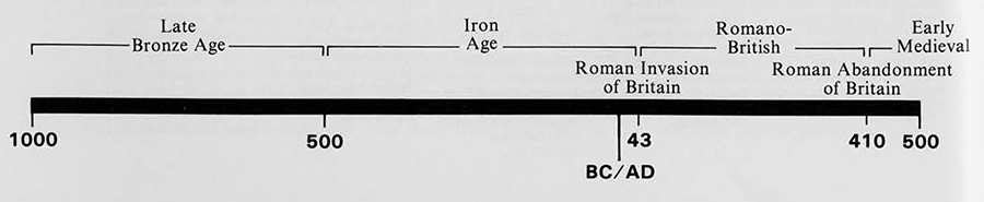
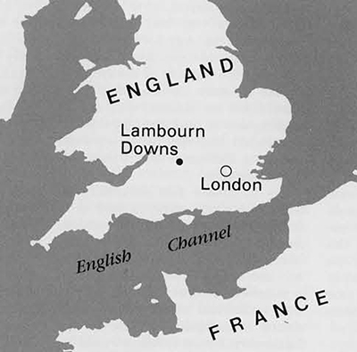
These questions are not easily answered. Our project near Lambourn in Berkshire (Fig. 1) included field systems whose dates were in contention. Some have thought the systems were established by prehistoric farmers, perhaps around 1000 B.C., while others have supposed they were laid out during the Roman occupation of Britain in the first four centuries A.D. By excavating the field boundaries and recovering datable artifacts, we have brought new evidence and arguments to bear and can now show that a Roman date is to be preferred for most of the Lambourn systems.
Dating Archaeological Features
In the absence of documentary evidence, there are two commonly used ways to date archaeological features. One is by associating them with other structures whose date is already known—fields with settlements, for instance. The second is by finding datable objects to which the features can be related. For example, if pottery of a known date is found in the foundations of a wall, the wall must postdate the pottery.
Earlier estimates of the date of the Berkshire Downs field systems relied heavily on the first of these methods. It can be assumed that the fields were worked, if not owned, by people who lived close at hand. However, few habitation sites have been located on the Downs, and only a very small number of them can be physically linked to the surrounding fields.
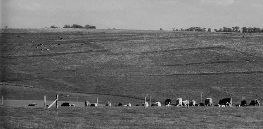
The most prominent inhabited sites are hill forts, large enclosures surrounded by ramparts and ditches, sited on the northern edge of the Downs where the land falls away abruptly to a broad valley. One of these, Segsbury, can be seen in Figure 2. Hill forts are known to be prehistoric, and one seems to have been built over an area previously occupied by fields that must then be older. Even though such a relationship could not be generally demonstrated, it was tempting to connect all such important sites with other archaeological remains in their neighborhood. Thus Richards, writing in 1978, said that “although dating evidence is not available, many of the fields under consideration, especially those associated with prehistoric settlements, for example Segsbury, must have their origins in the first millennium B.C.”
Another line of evidence was held to support this view. The Downs are crossed by long features called linear ditches, some of which are indicated by thick lines in Figure 2. Over 48 km of these ditches have been identified, though perhaps they were not all made at the same time. Their function is enigmatic. Possibly they were visual markers for the boundaries of territories, the ditches being accompanied by banks, or they may have had the more practical purpose of separating animals from cropped areas.
The date of most of the ditches is similarly uncertain, but some have been assigned to the early 1st millennium B.C. because of the pottery they contain. Aerial photographs seem to show the ditches cutting across field boundaries, and if that was so, the fields must have predated ditch construction (see box on mapping fields). Indeed it has been suggested that the linear ditches were dug at a time when the economy of the Downs was being reorganized, with a move away from crop cultivation to pastoral farming. Three isolated excavations of lynchets were also counted in favor of an early date for the Berkshire Downs field systems because they had yielded prehistoric pottery, but a reexamination of the data shows this to be doubtful in at least one case.
At the same time the possibility that the area was cultivated later on by the Romans (or more properly the Romano-British) could not be discounted. One indicator was the strip-like appearance of some of the fields, which were of a type known to be associated with Roman farming elsewhere in Britain. Such fields are clearly seen in Figure 2 near Maddle Farm, where there is also known to be the remains of a substantial Roman settlement.
In the early 1980s archaeological material was systematically collected from the surface over a large area around Maddle (Gaffney and Tingle 1989). Roman pottery was found to be thinly but widely distributed, and the most likely explanation for this is that it reached the fields in manure taken from middens on which household wastes were discarded. Several more dense but local scatters of pot sherds may indicate the farmyards in which the middens were situated. Very significantly, pottery of the later 1st millennium B.C. was not found in the area. So it seems that near Maddle at least, Roman farming was not immediately preceded by an earlier phase of cultivation, at least of a kind requiring the frequent application of manure.
Evidence that Roman occupation of the Downs was more widespread than this comes from the linear ditches, some of which have Roman pottery in the upper levels of their fills (Ford 1982). Ford’s work was done in the course of a general re-examination of the relationship between the linear ditches and the surrounding field systems, and in contrast to the earlier studies, it showed that the evidence for such ditches cutting through previously existing fields is very slight. It may be confined to just one block of fields, and even there the aerial photographs are unclear.
As a consequence of the Maddle survey and Ford’s work, support for a prehistoric date for the Berkshire Downs field systems as a whole was weakened, while the evidence for Roman farming, particularly near Lambourn, looked strong. But because the Romans farmed in the area, we cannot straightforwardly conclude that they laid out the landscape whose remains we now –see. They may have taken over older fields, perhaps modifying them by removing some of the boundaries to create the long rectangular shapes most suited to their cultivation techniques. Consequently doubts remained, and it was against this background of uncertainty that we undertook a systematic program of excavations aimed at dating the Lambourn Downs field systems more precisely.
Mapping Fields from Aerial Photographs

The outlines of former fields can still be seen in aerial photographs taken in favorable circumstances. Soon after cultivation their boundaries show up as soil marks created by differential rates of drying, and later on they may be picked out by color differences or variations in the height of a crop. By examining photographs taken at different times, so that features invisible in one set of conditions show up in another, a reasonable picture of the ancient landscape can be built up. Figure 2 is in fact a drawing made in this way from aerial photographs of the Lambourn region.
The blank area running north-south is a valley in which there are modern roads and villages. The fields lie on higher ground, some 150 to 200 m above sea level, on either side of the valley. They also extend both to the east and the west of the area figured, and it will be useful to distinguish the larger set of fields as the Berkshire Downs systems, while calling those in the drawing the Lambourn Downs systems. (Some of the earlier work on the date of the fields properly refers to the Berkshire Downs systems as a whole.)
A glance at the scale of the drawing will show how extensive the systems were. It should also be evident that the layout of the fields was not haphazard, but followed a more or less orderly pattern. This is particularly clear near the sites marked SH and WC, but it was probably the case over much of the area. The patterning indicates that blocks of land were enclosed at a single time, rather than being taken into cultivation piecemeal over a long period. So although only fragments of the systems survive as standing earthworks, any dates assigned to these fragments should be applicable to the surrounding areas.
The Excavation Strategy
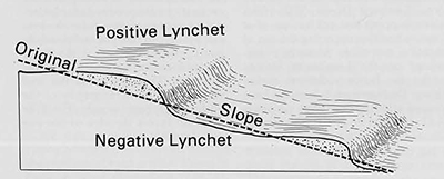
We dug trenches through surviving lynchets (see box) and located the position of each artifact found in them in three dimensions (Fig. 4). Our hope was to recover datable artifacts from the bottom layer of the soil accumulations making up the positive lynchets. Once this bottom layer has been covered by more soil eroding off the field, it should remain undisturbed, except perhaps by burrowing animals. And since the bottom layer contains the first soil to erode, the artifacts it contains, which are assumed to come with the soil from the field surface, will give at least a coarse date for the origin of the field. More precisely it is the youngest artifact that matters. For example, if several pieces of pottery ranging in date from 500 B.C. to 300 A.D., were to be found at the base of a positive lynchet, it is clear that the lynchet must have formed after 300 A.D.
The validity of this approach relies on manure containing artifacts being put on the fields soon after cultivation started. If the fields were not manured, or if broken household objects were not thrown away on the middens from which the manure came, the basal layers of a lynchet might contain no datable material. Worse still they might contain artifacts that reached the soil surface a long time before the fields were created. For instance, if a Roman field system was laid out over a former Bronze Age settlement site, Bronze Age pottery could well be found at the bottom of the Iynchet. In the absence of manuring there would be no Roman pottery to accompany it, and it might then be concluded that the fields were set out some 1500 years earlier than was in fact the case.
To minimize the possibility of making such an error, as well as to cope with the effects of random mixing of the lynchet contents by burrowing animals, we proposed to rely more on the overall picture from a number of trenches than on any one individual result. Our confidence in assigning a date to the Lambourn Down systems would be strengthened if we were able to find a similar pattern of results repeated from trench to trench.
Another problem was to locate the trenches in such a way as to get a good sample of such a large area. This was made no easier by the poor survival of lynchets through which to dig. However, as Figure 2 shows, we did find suitable sites in the center and towards the southern edge of both the eastern and western blocks of fields. We found none to the north, and there we tried to locate and excavate ditches alongside tracks that could be seen in aerial photographs to serve the field systems, unfortunately with no success.
The Results
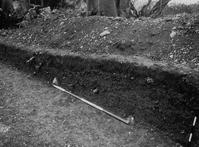
In all, 21 trenches were dug across 13 lynchets in eight separate locations. They all showed that the lynchets had a simple structure like that seen in Figure 3. At the base of the modern topsoil there was typically a thin layer of small stones, the result of earthworm activity. Below this was a relatively loose layer, 20 to 50 cm thick, representing the accumulation of soil in the positive lynchet, and below this were former horizons, presumably the remnants of the old land surface, though there was an obvious buried soil in one trench only. The important point here is that there was no obvious stratification within the lynchet accumulations themselves. This probably means that they formed as the result of one prolonged episode of cultivation. Had cultivation ceased for a time, allowing a stable grassland soil to form before crops were grown again, we should have expected to see traces of the stable episode in at least some trenches.
We recovered a few pieces of metal, including a simple Roman finger ring, a small number of flint implements and a much larger number of waste flint flakes resulting from their manufacture, and 663 pieces of broken pottery. The flint flakes are likely to have been struck from the nodules of flint abundant everywhere on the Downs. Indeed we accidentally discovered a site where flints had been knapped lying below one of the lynchets. The flakes indicate prehistoric activity in the area, and because they are so widespread they perhaps point to prehistoric farming involving the use of manure containing flint waste, but they are not sufficiently distinctive to be used for more precise dating purposes.
The pottery fragments were generally small and often much abraded, as would be expected if they had been exposed to the weather and cultivation implements in the fields. One hundred and thirty-three (20 percent) of them could not be dated because they were too damaged. Of the remainder, 493 (74 percent) were Roman and only 37 (8 percent) prehistoric. There was, of course, some variation in these percentages from site to site, as can be seen in Table 1. Sixty-three of the Roman sherds could be more precisely dated, the majority belonging to the first two centuries A..
Roman pottery predominated at every site, with prehistoric sherds reasonably well represented at only one, Eastbury Down (ED). This alone suggests that cultivation, or at least cultivation requiring the use of manure, was more intensive everywhere on the Lambourn Downs under the Romans than at earlier times. Furthermore it seems to have ceased after the 3rd to 4th centuries A.D., because no Saxon or medieval pottery was recovered. But the data set out in Table 1 do not meet the objection that the Romans might have reused older field systems, and to settle this point we need to look at the distribution of the pottery finds within the positive lynchets.
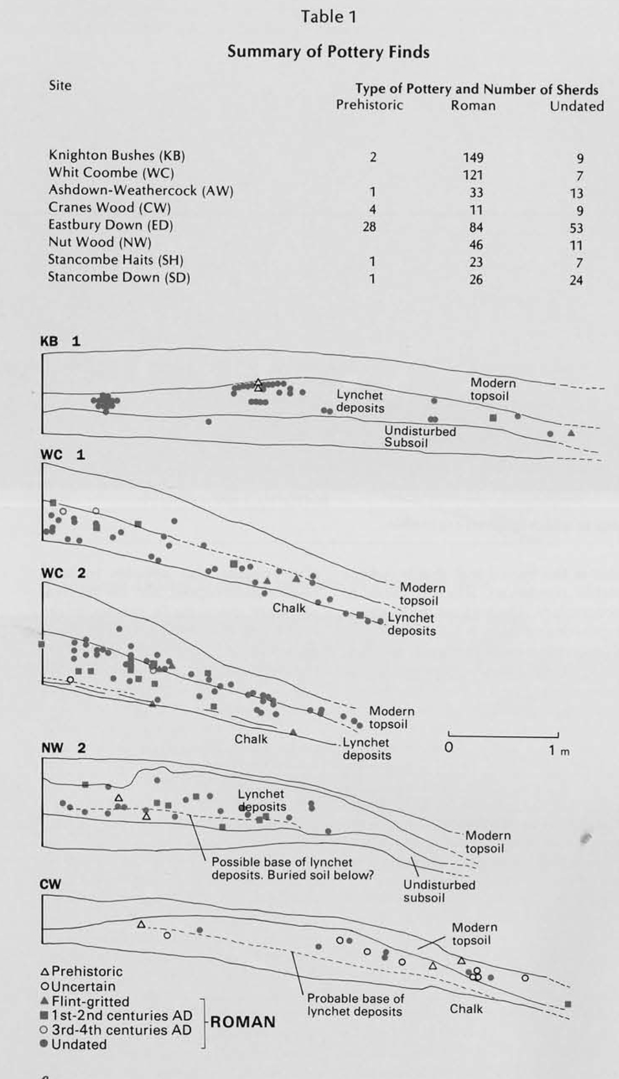
In all, 9 of the 13 trenches that were dug had Roman pottery close to the base of the lynchet soil accumulations. The first four sections drawn in Figure 6 illustrate this point, while the fifth (Cranes Wood or CW) does not. (The flint-gritted pottery in this figure is early Roman.) Consequently we feel satisfied in saying that the excavations did produce a fairly consistent pattern of results for the area as a whole, one that pointed clearly to many, perhaps most, of the fields having been laid out after the Roman conquest. This conclusion fits well with the simple stratigraphy of the positive lynchets, which, it will be recalled, favors the idea of just one episode of cultivation.
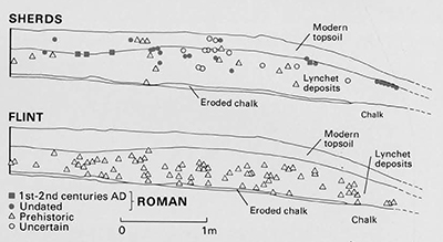
It is interesting to look more closely at the Easthury Down site where prehistoric pottery was more common than elsewhere. In one of the two trenches here, prehistoric sherds lay fairly clearly below the Roman. Furthermore the flint flakes tended to lie below the pottery (Fig. 7). Both of these findings suggest that in this instance we had sectioned a lynchet bordering a field laid out before the Roman conquest and continuing in use afterwards. Some support for such a conclusion was gathered when the surrounding lynchets were surveyed, because the resulting plan could be interpreted as showing a reorganization of the field system at some stage. Furthermore, as we shall show later, an analysis of snail shells from the site also fitted in with the idea of two phases of cultivation at Eastbury Down.
Although we have emphasized the perils of relying too heavily on the data from one site, these three lines of evidence taken together do seem convincing. If indeed the fields at Eastbury Down were altered and reused, we can feel even more confident in our general conclusion that large parts of the Lambourn Downs were first laid out by the Romans, for we ought to have picked up similar evidence for earlier use at some other sites if it had existed.
Environmental Evidence: Snail Shells
Some of the lynchets trenched were formed on shallow soils directly above the chalk bedrock, whose alkaline nature favors the preservation of snail shells. The old shells can be washed out of soil samples collected from the side of a completed trench, and the changes in species composition of the snail fauna during the lynchet build-up can therefore be followed. Because many of the species concerned are small, they are present in fairly high numbers, making such changes easy to detect. Some snail species can only survive in shaded, undisturbed habitats, while others are characteristic of an open, cultivated landscape, and yet others of open but grassy environments. A faunal analysis might therefore show what the countryside was like before cultivation started, and it might also reveal any episodes of stable grassland within the cultivation phase.
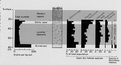
Figure 8 shows the results of an analysis at Whit Coombe (WC), the site at which a buried soil could be seen below the lynchet. It is simplified by leaving out certain species that were present in small numbers throughout the profile. Three points can be made. First, the total number of snail shells (the histogram on the left) was high at the base of the modern rough grassland topsoil and also in the buried soil, that is, where stable conditions allowed them to accumulate. Throughout the horizons representing the lynchet build-up the numbers were uniformly smaller. Second, the species composition remained more or less the same throughout the lynchet build-up. It differed from that in the buried soil where some snails characteristic of more moist and shady conditions were found, and also from the composition in the stony layer at the base of the modern topsoil where the representation of Pupilla muscorurn (which thrives in grassland habitats) was high. Third, Vallonia, Pupilla, Helicella and Hygromia, snails of open habitats, dominated all the assemblages, even those from the buried soil.
In the context of putting a date to the field systems, the first and second points are significant because they are consistent with the view that the lynchets were formed during a single uninterrupted episode of cultivation. Similar data from the other sites where a snail analysis was possible also supported this conclusion. Only at Eastbury Down was the pattern slightly different. Here the cultivation episode also appears to have been uninterrupted, but the survival of rather more shade species in the lower layers of the lynchet perhaps indicates a different cultivation regime to that responsible for the upper part of the build-up where shade species were absent.
It has to be said that the interpretation of fine differences between one snail fauna and another is problematic, and it would be unwise to rely too strongly on the arguments just presented. However, the fact that all the assemblages, even those from the pre-lynchet soils, were in every case heavily dominated by open country species must be significant. It means that the field systems were not laid out in anything like a natural environment, for in southern Britain this would be deciduous woodland. The Downs must have been cleared long before, and they were probably cultivated at least intermittently because the prelynchet snail faunas are strikingly unlike those of modern-day open but uncultivated habitats (trackside banks, for example), and more like those of cultivated fields. How often the area was cultivated is difficult to say because once the original snail fauna of a site has been destroyed, it seems (on the Downs) to recover very slowly indeed when the disturbance ceases. Snails disperse slowly, and they presumably find it difficult to recolonize suitable habitats if to do so they must cross environments that are still hostile.
Wider Implications
It now seems very likely that many of the field systems still to be seen in vestigial form on the Lambourn Downs were set out after the Roman conquest of Britain. With less certainty it can be predicted that similar field systems in the wider environment of the Berkshire Downs as a whole will also be found to be Roman. The fields were kept in intensive cultivation for a time, with quantities of manure applied to maintain their fertility. Thereafter, they were left comparatively undisturbed so that their boundaries survived until they were destroyed by a resurgence of farming in the middle of this century.
Because many of the lynchets on the Downs have a Roman origin, we are left with rather sparse evidence for land use in the area before the conquest. The snail analysis and the ubiquitous scatters of waste flint flakes may indicate cultivation, but when and to what extent is quite uncertain. However, because there are few prehistoric lynchets, we have to assume either that they were plowed out by the Romans or, more probably, that the prehistoric cultivation techniques in this area did not favor their formation. Perhaps we should picture crops grown purely for subsistence by a small resident population that mainly depended on grazing animals. The area in cultivation at any one time would then have been limited, and it could have been shifted to a new location at frequent intervals to maintain fertility. Such a picture is plausible given the unfavorable nature of the Downs for agriculture by comparison with lower lying, more fertile soils nearby. However, if this picture is correct, it highlights the question of what incentive the Romans can have bad for farming the area more intensively. It is easy to see that the agricultural economy of southern Britain might have been revolutionized towards the end of the 1st century A.D. by the presence of a large army needing supplies, as well as by the growth of towns. Both would have offered grain producers guaranteed markets and cash payments, something they can never have had on any scale before (Saiway 1981). Indeed the situation after the conquest may have shared common features with the later 20th century, when price guarantees also led to the expansion of cereal farming onto the higher ground of the Downs.
An explanation along these lines for the establishment of large areas of cultivated fields looks attractive, so it is unfortunate that our excavations failed to show clearly that the lynchets had a 1st to 2nd century origin. There are alternative possibilities. For example, it is known that large quantities of grain were shipped from Britain to Germany and Gaul later on in the Roman period when the continental economies had been disrupted by invasions, and this too might have caused the expansion of agriculture in the Lambourn region. Another explanation might be connected with the settlement of army veterans on the land. There is no certain evidence for this practice in Britain, but it too could account for the organized layout of fields over rather large areas. Obviously much more evidence would be needed even to convert such speculations into respectable hypotheses, but whether it will now be forthcoming is, sadly, doubtful given the poor survival of the Roman landscape.