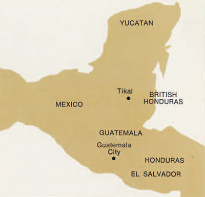
 For the weeks, months, and even years one spends carrying out fairly routine work there is always the possibility of stumbling onto something important that is totally unexpected. The discovery of what appears to be a 9 1/2 km. long defensive earthworks 4.5 km. north of the Great Plaza of Tikal is an example of just such a chance. The earthworks lie directly between Tikal and the nearest large site, Uaxactun. These two sites are about five hours apart in terms of walking distance; the earthworks are one hour’s walk north of Tikal. Frankly, a defensive barrier of this magnitude, or for that matter of any magnitude, was not one of the things we expected to find in the process of a project to explore and map the outlying areas of Tikal.
In view of their great achievements in art, astronomy, and architecture, their dispersed settlement, and the general absence of evidence for fortifications of any kind, the Classic Lowland Maya (A.D. 200-900) have gained the reputation of having been relatively peaceful. Though recent discoveries in the Usumacinta drainage, including the famous Bonampak murals, are beginning to reverse this, warfare on a level higher than “raids” is generally felt to have been introduced very late in Late Classic times by invaders from Mexico. Evidence from the Yucatan peninsula has been taken by some to support this view of Late Classic and Postclassic (A.D. 900-1500) warfare and degeneration. The Postclassic sites are often pictured as having cruder architecture, a degenerate calendrical system, and political instability as reflected in the prevalence of settlement within and around walled sites such as Mayapan and Tulum. In the Guatemalan Highlands a move to defense-oriented sites has been linked in a similar manner to the advent of the Postclassic. It is our thesis here that some students have overplayed this contrast between Classic and Postclassic and that internecine warfare, such as the Spanish found the Maya engaged in upon their arrival both in the Highlands and in Yucatan, was also practiced in the southern Lowlands in Classic times.
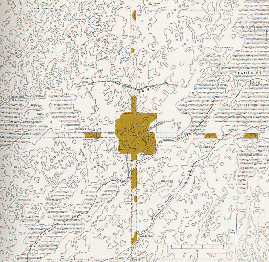
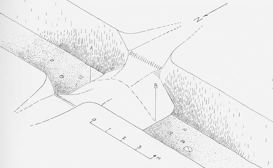
The Tikal earthworks were discovered in the process of the systematic mapping of the remains of house platforms and other structures along the 1/2 km.-wide, 12 km.-long strip which extends north from Tikal’s center. The trench is the most prominent feature of the earthworks, but when it was first discovered it appeared to be nothing more than a natural arroyo or ravine. As we followed it, however, it soon became evident that it was not a natural formation. First, it had a continuous raised embankment along the south side, and second, it passed up and down over hills, following a fairly straight line. At several points where we came to low ground it seemed to disappear, but by continuing on we were always able to pick it up again on the next piece of high ground. These gaps can be seen on Fig. 1. Otherwise, the earthworks were easy to follow. We soon found it easiest to walk along in the trench itself, though occasionally fallen trees of great size blocked our path, forcing us to crawl through a dense tangle of branches or make a detour. We soon found it easiest to walk along in the trench itself, though occasionally fallen trees of great size blocked our path, forcing us to crawl through a dense tangle of branches or make a detour. We followed the trench in this way for a total of three days. Compass bearings were taken every 40 to 50 meters and distances were paced off as accurately as possible, revealing finally that over their known length the earthworks extended for a total of 9 1/2 hm. At both the east and west ends the earthworks disappeared into large swamps through which they may or may not have continued. We were particularly interested to note that the ends almost reached the two great logwood (Haematoxylumcampechianum) swamps that lie to the east and west of Tikal.
With the realization that this new feature was not natural, but was something constructed with great effort by the Maya themselves, we were left with the question of why? What was the function of this great trench and embankment situated so far from the center of Tikal? At first we considered the possibility that it might have served as a canal in a water distribution system of some kind. However, this intriguing idea had to be rejected on the basis of two factors, both of which preclude the possibility that the trench could have held water: first, the extremely porous nature of limestone bedrock; and second, the way in which the trench goes up and down the sides of large hills without changing its depth.
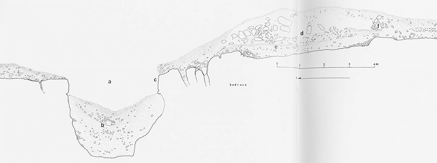
(a) trench,
(b) a fragment of the collapsed north lip,
(c) original face of the south side still in place,
(d) the embankment, built up with limestone removed from the trench,
(e) pre-trench layer of topsoil,
(f) rubble retaining walls.
On the other hand, its potential as a barrier to human movement was obvious for at least three reasons. (1) Though we did not know its depth before we began excavation, the four-meter width of the trench posed an obstacle few Maya could have crossed by jumping. To have tried to do so would have been additionally difficult for two reasons. First, over almost its entire length outsiders would have had to run uphill to approach the trench, and second, they would have had to jump upwards, as well as across the trench, to get onto the embankment which abutted the south lip. In looking at Fig. 2 it should be remembered that this embankment must have been considerably steeper and higher a thousand years ago than it is today. (2) The logwood swamps to the east and west would have made it difficult to get around the ends of the earthworks providing they were as unpleasant to struggle through in the days of the Maya as they are today. (3) Finally, that the trench was impassable is suggested by the fact that at four or five widely separated points along its length we found what appeared to be causeways across it. At each of these there was an equivalent gap in the embankment. If the earthworks were not a barrier to human passage these “gates” would have little reason to exist.
Given that the earthworks functioned as a barrier to human movement we were left with the question of what kind of movement? As well as a military line of defense they might have served to control trade or collect taxes in produce as it came into the city. In spite of the various possibilities, however, the magnitude, construction, and orientation suggest that they functioned first to repel organized bands of hostile invaders from Uaxactun, rather than to control friendly traders headed for markets in the city or subjects of the realm of Tikal itself. This does not mean that other functions may not have been served. We feel, however, that these were probably of secondary importance.
Having completed exploration one question now predominated. When, in the long history of Tikal, were the earthworks constructed and in use? If warfare and internecine fighting was truly a Postclassic introduction (i.e., after A.D. 900) we would expect them to be very late. Obviously this and other questions regarding the original depth of the trench and the construction of the embankments and causeways could only be answered by excavation.
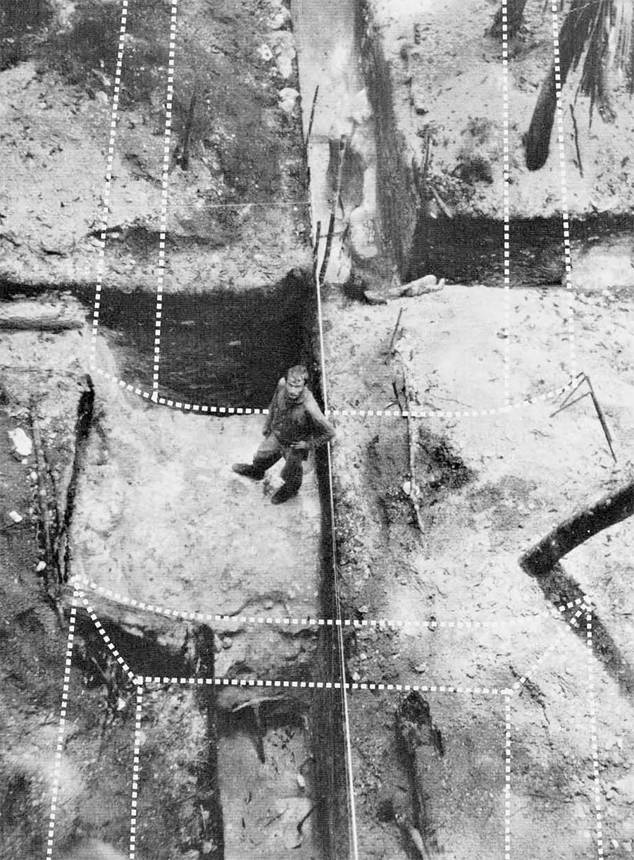
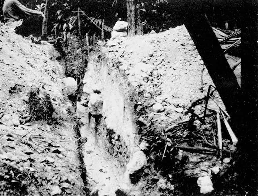
Three separate excavations were carried out along the trench and are labeled on the large map A, B, C, in the order in which they were dug. The first was a long excavation across both the trench and its embankment (Fig. 2). Several days’ work in the trench revealed that it had been cut into limestone bedrock to a depth of three meters and that in its original state the walls of the trench had been nearly vertical. Clearly, anyone who might have fallen into it would have had some difficulty in getting out. The limestone rubble and earth removed in its excavation were heaped up on the Tikal side behind loosely constructed rubble retaining walls, without the benefit of any sort of finished masonry. In the original topsoil, buried beneath the embankment (fig. 2, e), a possible Early Classic potsherd was found. This could only suggest that construction was Early Classic or later. The three other sherds we found could not be dated at all. At the end of this excavation we had to face the fact that although we had secured valuable data on construction we had made little progress in the problem of dating. There was nothing to say that it was not Postclassic and, except for the one sherd, it might just as well have been Preclassic (i.e., prior to A.D. 200).
It then occurred to us that if indeed the causeways across the trench had served as funnels for human traffic the likelihood of finding ceramic materials in their vicinity would be much higher than it would be elsewhere. We decided to make a causeway our next object of endeavor (Fig. 1, B). It was not long after we began that we started to find in quantity the ceramic material we were after. It was predominantly early to middle Late Classic (A.D. 600-800).
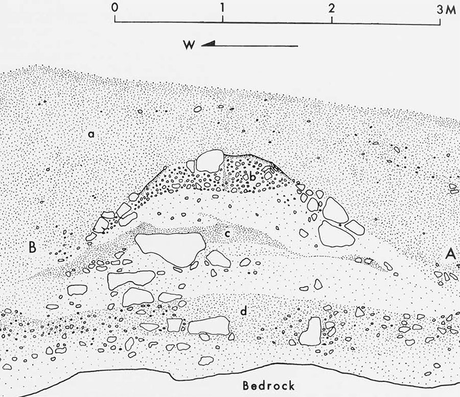
The causeway, as revealed in its cross-section (Fig. 3), had a history of its own. First of all, before the construction of the causeway a substantial amount of silt had collected in the bottom of the trench (Fig. 3, d), indicating that the trench existed for some period of time as a barrier without a causeway, at least at this point. Almost no sherds were found in this pre-causeway layer. The causeway (Fig. 3, b and c) was apparently built in two stages, and the earlier stage may have been in use for a while before the construction of the later. This later stage (Fig. 3, b) was well made, being finished with a thick concrete-like mixture of pebbles and lime plaster. It was quite narrow and would have permitted only one or two persons to pass at a time. It appears to have been during the use of this causeway that most of the sherds we found were deposited. Although most of this material dated to early and middle Late Classic there was also some Early Classic. A definite Early Classic rim-sherd was found in the topsoil beneath the embankment here, at last eliminating the possibility that the trench was dug in Preclassic times. Significantly, there was no evidence of Late Classic or Postclassic, indicating that the causeway was probably not in use at this time. The potsherds were found in two situations: as primary deposits, in the bottom of the trench beside the causeway; and as secondary deposits, mixed with the earth used in the final in-filling (Fig. 3, a). Robert Fry, who was analyzing this material, pointed out that the quality of much of the pottery was on a par with what might be found in the heart of the ceremonial center, and not all like the domestic refuse one might expect to find in such a rural location. He noted large quantities of decorated ware forms including flat-bottomed tripod bowls, curved-bottom tripod bowls, and even the remains of some pottery drums. All this seemed to indicate the use of the causeway as a funnel for trade as well as other forms of human movement.
All during this time, then, the earthworks would have continued to function as a barrier over most of their length. The very quantity of potsherds found in the vicinity of the causeway stands as evidence of this. At some point in time, however, probably with the advent of Late Classic times (A.D. 800), there must have been a distinct change in the nature of Tikal’s relationship with Uaxactun. First, large blocks were broken off the north lip of the trench, from which point they fell into the bottom. Then the whole area of the formerly narrow causeway was filled in with earth, apparently scraped up from the surrounding area (Fig. 3, a), creating a broad passage across approximately ten meters of the trench’s length. What had happened? We might suggest that the necessity of the barrier had been obviated by the establishment of some lasting peace through agreement, or perhaps one of the formerly separate, warring states of Uaxactun and Tikal had finally triumphed, creating a unified region under one government. Only further research will shed light on these new possibilities.
All this speculation was very stimulating, but one major practical problem remained to be resolved. If, indeed, the trench had served in its heyday as a great defensive barrier, how was one to account for the various apparent wide gaps we had discovered during the initial exploration? The fact that these occurred in areas that might be considered swampy led to the suggestion that given slightly different climatic conditions, these swamps might have been much thicker than they are today and did not need to be defended. The other possibility, of course, was that some manmade barrier, such as a palisade or moat, had been present, but was no longer visible on the surface. At point C on the map there was a gap of about 65 meters. Near the center of this we laid out an excavation at right angles to the line of the hypothetical barrier and began to dig. In contrast to the light dry soils of the high ground we had been excavating up to this point, we found ourselves in a thick black much that clung in infuriating clumps to the picks and shovels alike.
After several days of backbreaking labor on the part of our workmen, the black muck began to grade into deeper grey clays along the full length of the excavation with the exception of a six-meter wide section near the center. This section, it soon became evident, was all that remained of the great trench which had long since filled in completely. At the edges we could clearly see where the grey clay had peeled away from the sides of the trench in large lumps and fallen into the center, to be buried in the black muck that must have flowed in from the surface with each rain. This process of erosion was dramatically illustrated to us when on the last morning of the season we went out to complete our drawings only to discover that, during the night, the sides of our own trench had collapsed inwards burying an incautious workman’s tools and most of several days’ work. In spite of this loss our problem was solved. We now know that the trench had once crossed the swampy areas, though we could only wonder at how the Maya maintained it,
Viewed as a whole, the significance of this discovery seems to lie in the fact that the earthworks were found so far from the center of Tikal. The limited exploration of most Lowland Maya sites makes it impossible to say that defensive earthworks of this nature are unique to Tikal or even rare. The trench we have described above is crossed at one of its more impressive points by the well-traveled trail between Uaxactun and Tikal. Many well-known archaeologists have crossed it without recognizing it for what it was, probably with some discomfort as their mules slid down or scrambled up the steep south edge. Who is to say that similar earthworks do not exist elsewhere? At least one somewhat comparable earthwork is known for the site of Becan about 150 kilometers NNE of Tikal. It consists of a deep moat crossed at seven points by narrow causeways, but differs in that there is almost no embankment, it is circular, and it served to protect only the ceremonial nucleus of the site, a small area of less than a quarter square kilometer. From the functional standpoint, the Becan situation seems to be similar to the elevated and fortress-like residential and ceremonial plazas characteristic of many of the smaller Lowland sites including Tikal. This is in contrast to the Tikal earthworks which include between themselves and the Great Plaza of Tikal something on the order of 30-40 square kilometers of land. This area is thought to have been occupied predominantly by the less affluent lower “classes.”
Why was so much effort expended to protect this land so far from the concentrations of wealth and authority in the center? As a possible answer we suggest that the inhabitants of Tikal, including the upper echelons of nobles and priests who must have had the power to order the construction of such a defense, were interested in protecting the agricultural resources upon which they ultimately depended. In answering the next question as to how hostilities between Tikal and Uaxactun could have reached such a level, it seems plausible to surmise that tensions increased as populations expanded. Surely, as the agricultural sustaining areas of the various centers grew and at last began to infringe upon each other, disputes over land could have developed into deep-seated enmity between the cities, and, eventually, war. The evidence above indicates that the earthworks were constructed sometime within the range of Early Classic and Late Classic times, and this correlates in a remarkable way with changes in physical stature. William Haviland, in studying Tikal burials, has recently discovered a sharp drop in stature with the advent of Late Classic times which he attributes to malnutrition. The correlation of increasing population, malnutrition, and warfare seems logical. One might speculate that as available food-producing land per capita decreased and antagonisms increased it would have become increasingly necessary to defend vulnerable agricultural areas.
Finally, we want to point out the political implications of this construction. It appears to indicate rather dramatically Tikal’s existence as a single unit, at least in the minds of the builders of the earthworks. Evidence from central Tikal has been taken by some to suggest rival lineages and priestly cults with minimal political unity. The earthworks, on the contrary, seem to point to the existence of a central authority with the power to order the construction of a really massive public project for the good of Tikal as a whole. In regard to the benefits this project might have provided for the inhabitants of Tikal, the earthworks stand in contrast to most other monumental efforts including temples, pyramids, and palaces, which appear to have been constructed primarily for the glorification or benefit of particular individuals or lineages. The unprestigious and more functional nature of the earthworks is reflected in their lack of finished masonry or other adornment.
In conclusion, we feel that perhaps the greatest significance of the earthworks lies in their potential as a sensitive gauge of the apparently changing nature of Tikal’s relationship with its nearest large neighbor Uaxactun. Here is one of those rare instances when hazy shadows of something approaching history begin to emerge.