In June 1967 I was invited to the Republic of Ireland by Mr. John Cohane, of County Limerick, to visit with him the site of Dun Ailinne. This visit led to discussion with the National Monuments Branch of the Office of Public Works on the possibility of excavating this site at some future date. Mutual interest led to an informal agreement, and during the winter of 1967-68 a season of trial work was planned jointly by the National Monuments Board and the University Museum: the former to provide labor and equipment, the latter to provide a director (myself), a magnetometer survey (by Miss Ralph), and other assistance that might seem advisable.
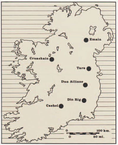
Dun Ailinne is one of the ‘Royal sites’ of Ireland: those sites that are identified with one or another of the early historic dynasties of late Pagan and Early Christian times—roughly the first millennium A.D. There are a number of these sites: Tara, undoubtedly the best known; Cashel, seat of the Kings of Munster; Emain Macha, of the Ulster Kings; Cruachain, of the Connaught dynasty; Din Rig, and others. Dun Ailinne, like Din Rig, is associated with the Leinster dynasty.
These sites are not too well known archaeologically, I would judge for two main reasons. Firstly, Ireland is very rich in ancient monuments, and the ‘Royal sites’ are by no means the only series of sites to attract archaeological attention—for example, there are great numbers of megalithic tombs, some of considerable size and complexity, and of very substantial significance in the prehistory of western Europe. Secondly, the ‘Royal sites’ are rather difficult to assess archaeologically, for reasons which may be summarized below. Documentary evidence indicates that these sites had great timber halls, where entertainment was held in some style, and the Irish metalwork of the period strongly suggests that a ‘Royal site’ probably housed craftsmen and their workshops. Indeed, some archaeological evidence is available from Tara both for buildings and metalworking. But there are no very evident surface traces on the sites of such structures and activities. On the contrary, the most visible surface features are often not connected with royal residence of the first millennium A.D. Thus the ‘Mound of the Hostages’ at Tara proved, on excavation, to be a megalithic passage-grave of the Late Neolithic, about 2000 B.C. , and Cashel is largely covered by later ecclesiastical buildings. Limited excavation has taken placed at Tara, Emain Macha, and Cruachain, it is true, but has not been extensive in relation to the total size of the sites. So we still know relatively little archaeologically of these sites, and cannot add a great deal as yet to the scanty historical references.
These problems become clearer when we glance at the plan of Dun Ailinne. Its size is considerable, the bank enclosing some thirty-seven acres of hill-top. Documentary evidence suggests that it was constructed and first inhabited about the time of the birth of Christ, and abandoned by the eighth century A.D. But how was it used? what went on there? was it indeed ever ‘occupied’ in the archaeological sense of buildings being erected, domestic refuse scattered about, and so forth? That these questions are not quite so odd as might appear can be illustrated by considering the enclosure itself. This is a substantial bank, but its ditch is inside (the same is true of Emain Macha, and the central enclosure at Tara), and the normal ‘hill-fort’ of this period in northwest Europe not only usually had two or more ramparts, but had the ditches outside the banks, as the commonsense of defense construction would suggest. The only class of circular earthwork with the ditch normally inside the bank is the ‘Henge Monuments’ of the Late Neolithic in Britain, and these are certainly ‘ritual’ rather than defensive in purpose. Furthermore, there is no internal point at Dun Ailinne from which a commander could view the whole of the perimeter: the placing of the bank in relation to the slope of the hill does not permit a view of more than about one-quarter of this bank from any interior position. Again, this does not seem effective defense construction, and again contrasts with the true hill-forts.
The foregoing both outlines our relative ignorance of these ‘Royal sites’ and suggests that they could be more complex to interpret than the documentary evidence indicates. Our problem at Dun Ailinne, in simplest terms, was to determine whether or not the site was archaeologically worth major investigation. More specifically, the main question was whether there was any trace of substantial occupation, and of what period this might be if it existed. With this broad mandate, four weeks’ work was conducted at Dun Ailinne in June and July 1968. Miss Ralph came to conduct a magnetometer survey, covering som 10,800 square meters with intensive readings, mainly over the top of the hill, and testing the rest of the interior of the site with more rapid exploratory survey. Five graduate students of anthropology came from the United States (three from the University of Pennsylvania); nine students joined us from University College, Dublin, and we employed about twenty-five local workmen. The work was speeded considerably by the use of a mechanical excavator for turn-removal, back-filling, and other work where careful hand-labor was not essential. This group, most efficiently equipped by the Kilkenny depot of the National Monuments Board, was able to carry out a substantial trial excavation in the time available.

1968 Excavation
On the east side of the site (Section II) we cut two sections through the enclosing bank. This proved to have been built at one time, without subsequent reconstructions, and to have been constructed simply by dumping the material excavated from the ditch downhill to form the bank. Cutting 23, just inside the inner edge of the ditch, showed no trace of any internal features, such as a palisade.
On top of the hill Section I, the Embankment, is an arc-shaped bank some 40 meters across the chord of the ‘bow.’ Though fairly low, it is steep-sided, and so does not seem to be of any great antiquity. Moreover, it is not similar to any known type of finished or unfinished earthwork of antiquity in the British Isles. Dun Ailinne is close to the Curragh, which has been used extensively as a garrison and military training area under both British and Irish rule, and it seems possible that our Embankment is some temporary military construction, perhaps a large artillery lunette. Cutting 1, excavated across this feature, produced no dating evidence, so this question remains unresolved. But at the west end of the trench, pits and post holes were found sealed under the Embankment. A scatter of flint and stone artifacts, including two small stone axes, was also found in this area: typologically, this material is Neolithic.

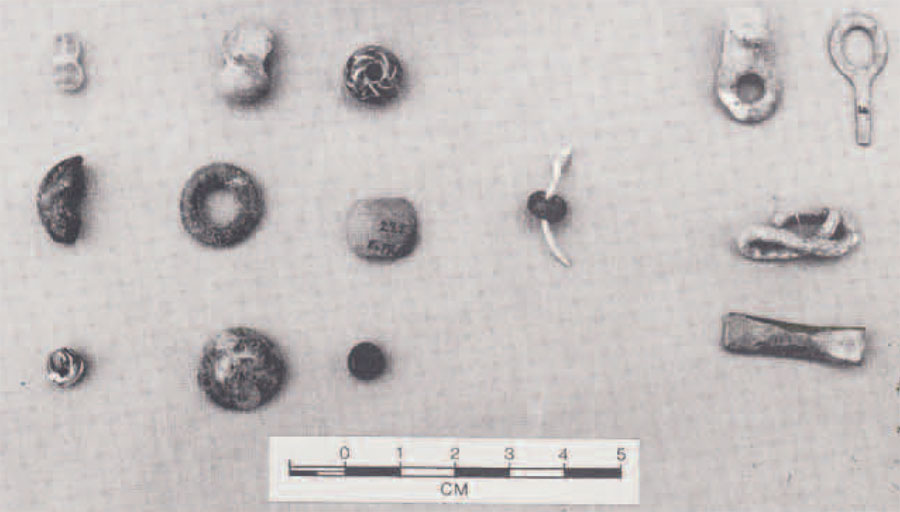
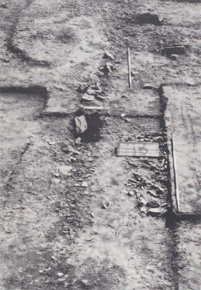
Just to the northeast of the Embankment a low mound (this and the adjacent area are Section III) showed the only large and clear magnetic anomaly in the whole area. When the modern turf was lifted, evidence of fairly intensive occupation appeared immediately: bone, charcoal and other evidence of domestic refuse were abundant. The uppermost 20 cm. or so were disturbed plough-soil, containing artifacts of various periods including some unmistakable of World War I vintage! But underneath this was an undisturbed occupation level, roughly coincident with cuttings 46-46 and 46-48. We excavated the north, west, and south edges of this occupation level, and found that the level increases in thickness the closer to the center of the low mound, which thus appears to be composed at least largely of occupation debris. This occupation level runs out eastwards towards (but not into) cutting 50-48, and westwards under the northern end of the Embankment, so the bulk of it, including probably the thickest parts, remains to be excavated. Slightly curved trenches cut into the subsoil on the north and south edges of the exposed occupation suggest that this area may have been surrounded originally by a fence, palisade, or similar enclosure. The artifacts from this level include some small pieces of bronze and some glass beads, none closely datable on stylistic grounds, but all can be generally paralleled in the Roman period and Migration period of northwest Europe – i.e., the first few centuries A.D. Elsewhere within the site, cuttings were made to check magnetometer anomalies or slight surface irregularities, but no other area of occupation was found, nor did the magnetometer survey show any probable archaeological anomalies elsewhere within the site.
The 1968 exploratory season thus showed that there is indeed an occupation area, approximately of the period indicated by the documentary evidence, and any further excavation should give priority to excavating this zone. Further exploratory work inside the site should be done to see if there are other such areas, and to investigate further the presently enigmatic post holes and pits shown in the west end of Cutting 1. Finally, it cannot be shown yet that the bank and ditch are of the same period as the occupation at the top of the hill, so further work must be done to clarify this. Continued work at Dun Ailinne should begin to give us a clearer idea of the nature of an Irish ‘Royal site’, and throw some much needed factual light on the rather shadowy historical evidence for the nature of these sites and their use.
In conclusion, we are most grateful to the National Monuments Board and the University Museum for sponsoring our work, and the Irish National Monuments Advisory Council for sanctioning it; the Ford Foundation for providing Field Traineeships for the five U.S. students; many Irish archaeologists for their kindness in visiting us, arranging for our visits to other sites, and entertaining us; and many Irish for their hospitality both connected and unconnected with our work. In particular we must thank the landowner, Mr. Thompson, not only for his permission to disturb seriously his grazing land, but also for his unfailing courtesy in contemplating this disturbance.