The Family, the House, the Gardens
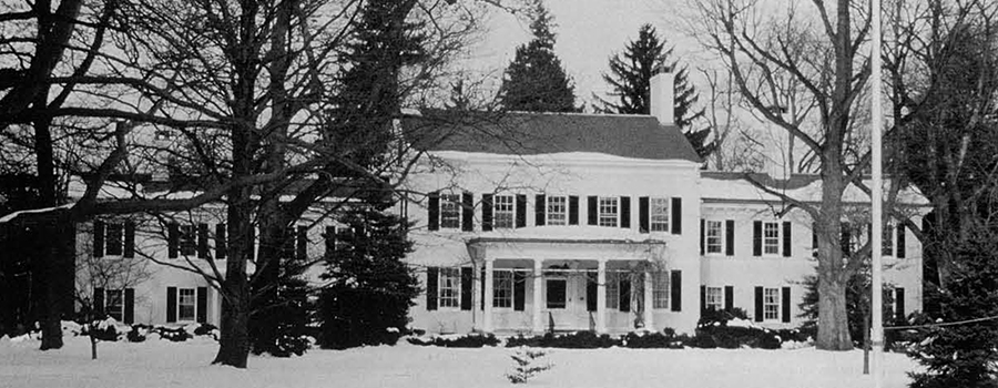
Ink the late 17th century the first Stockton family moved to Princeton, and in the mid-18th century their grandson, Richard Stockton, was deeded his share of the family property along the King’s Highway, now Stockton Street. Richard Stockton was in the first class to graduate from Princeton University; he became a well-known New Jersey attorney and also taught law. He married Annis Boudinot, daughter of a once prosperous French Huguenot family. Their home, named Morven, became a center of gracious hospitality in Princeton, a gathering place for the political and intellectual elite in the region, and “an outpost of sensibility” (Bill 1954).
Richard Stockton died in 1781. When Annis made the decision to advertise Morven for rent two years later, the house was home to five children aged 10 to 20. Its yard contained a carriage house, a granary, an ice-house, a wagon house, and two ornamental gardens. A contemporary description of Princeton suggests both gardens were in disorder and in need of repair. Also, the house had been damaged during the Revolution. Twentieth century historians disputed the extent of the destruction to the original home, and in 1987, no one knew for sure whether the pre-Revolutionary Stockton gardens were simple or ornate, designed for pleasure or created as productive working areas attached to the family farm.
Morven is one of the state’s most historic homes and served as the governor’s mansion between 1953 and 1981. In 1986, Governor Thomas Kean gave responsibility for administration of the house and grounds to the New Jersey Department of State, where, under the guidance of Dr. Alvin Felzenberg, it was placed as a satellite museum within the jurisdiction of the New Jersey State Museum’s Bureau of Cultural History. Since no documents clearly and unambiguously described the gardens in detail, and since preservation of the house and its gardens clearly required knowledge of their prior form and use, the New Jersey State Museum hired an archaeological team to provide them with material evidence of the gardens’ development over time. The team consists of a historical archaeologist and two specialists in archaeological plant remains.
The archaeologists at Morven work with dual objectives: (a) finding and documenting a series of previous gardens and (b) exhibiting the process of archaeology to the public. The process they are called upon to exhibit is both intuitive and humanistic, deductive and scientific. Each of these elements comes into play at different points in the research process—a process that includes consideration of the surviving natural elements in the landscape, recovery of earlier plant remains, recovery and identification of garden features, and delineation of a garden form based on Georgian models of measurement, design, materials, building techniques, and horticultural practices.
Trees as Surviving Elements of Earlier Gardens
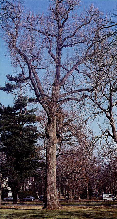
Trees are like people in that some look much younger than their years, while others look far older. On a continuously occupied lot, the latter merge with the former to create a deceptive blending of past and present. Today, the tree at Morven that looks most stately and old is a large tulip tree (Liriodendron tulip-if era; Fig. 3), located in line with the main block. In local family history, it is said to have been planted by Richard and Annis Stockton when they were married in the 1750s (Bill 1954:21), which would make it a historical marker. It is a fallacious marker, however, for the tree-ring cores indicate it was planted in the mid-19th century by one of Commodore Robert Field Stockton’s gardeners and not earlier (see Table 1, sample 16). Thus, the tree’s actual association is with the third generation of Morven households rather than the first.
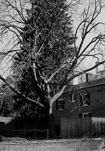
Oral tradition, when it becomes embedded in family legend, serves as a mechanism by which families interpret, reinterpret, and remember events important to them. As subsequent generations tell and retell narratives of the past, they transform them in response to historical change (Simmons 1991). Possibly the tulip tree became an ancestral tree when an earlier horse chestnut, known as the “patriarch tree,” was blown down in the early 20th century. Yet the location of the patriarchal horse chestnut, adjacent to the northeast corner of the main block, suggests that it was a “volunteer” rather than part of the original planting. People rarely planted trees in such close proximity to their homes in the 18th century, believing in the potential ill effects of night airs and miasmas that could be caught and trapped in. the foliage.
At the same time, the wide girth (supposedly in the range of 9 ft) and height of the patriarch tree support the family contention that it was an aged plant (Hodge-Magie, ca. 1920). The other horse chestnuts on the property are in the range of 200 years old (Fig. 2). Whether or not the patriarch tree was as old or older than these trees is not known.
The estimated ages of the Morven trees that were dated indicate that at least four or five different age sets exist on the property today (see box on generations of trees and Stock-tons). Included among these is a grove of tall Norway spruces that appear old because of their height (80-100 ft). Although their age is in the range of 75-85 years, they are young in terms of the garden’s origin. They were planted after the turn of the century by Helen Hamilton Shields Stockton, who created a glorious colonial revival garden in the north yard by bringing in new garden soil, leveling slumps and hollows, and refilling the original second terrace. The garden she built raised the yard surface higher than its mid-19th century plane and provided further protection for the original garden.
The Chestnut Walk
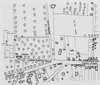
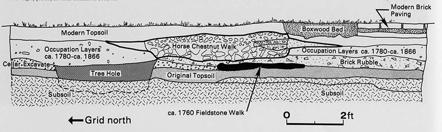
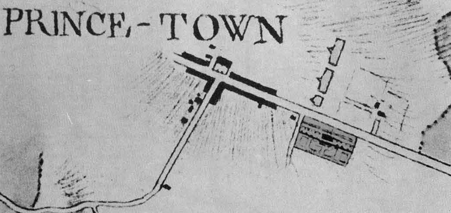
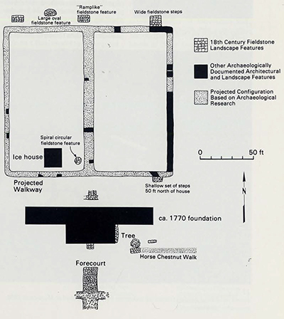
It was serendipity that led ethnobotanist Naomi F. Miller, associate director of landscape archaeology at Morven, to notice a horse chestnut tree just outside the property’s wrought iron fence. Its linear placement relative to another horse chestnut was suggestive; the trees appeared to border the path of a “horse chestnut walk” leading from the town of Princeton to the mansion as shown on mid and late 19th century maps (Fig. 5). Entries in a 19th century diary also mentioned the horse chestnut walk, but no one we spoke to knew its age or history. In fact, it no longer existed. Oral tradition surrounding the property contained hints that the walk might have been as old as ca. 1770 (Bill 1954:21). It was one of the garden features that the New Jersey State Museum asked archaeologists to locate.
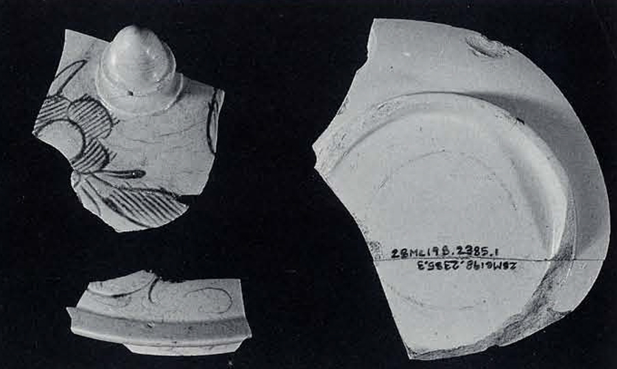
The living horse chestnut trees provided the material clues that allowed expeditious recovery of the walk. Excavation of a 5 by 5 foot unit in 1988 exposed a substantial walk of finely crushed gravel on a bed of broken, recycled cut stone (Fig. 6). Small pieces of 19th century white wares (first produced ca. 1840) dated construction of the walk toe the era of Commodore Stockton, as did its depth. Buried beneath it was a fieldstone walk, 75 years or more older than the Commodore’s walk.
A question that still remains is whether the horse chestnut trees (dated to the time of Richard “The Duke’s” household) were set out as replacements for even older trees or as original plantings. Hints that they might be replacements for older trees are contained in a very small military advance map made in 1781 by Rochambeau’s cartographer, Louis-Alexandre Berthier; this map shows the location of houses and other militarily important landmarks in the Princeton community.
The greatest detail in this map is provided for the terrain immediately surrounding Morven, perhaps because the British used the mansion in 1776 as their headquarters, and the American troop encampment of 1781 was across Stockton street from the house. Known outbuildings are not shown, and the map was not used as a planning tool in the 1987 excavation strategy in part because of this omission. It also seemed foolhardy to plan a whole season of field excavation for a 4-1/2 acre site on a map detail that would almost fit on the head of a pin, and certainly could fit on a soldier’s large coat button. However, as more has been learned of the configuration of the planting beds on the second terrace, the Berthier map has been shown to possess greater accuracy in its small detail than initially believed. We now know that the lines defining the large planting areas in the north yard actually denote the location of fieldstone walks bounding these beds (Fig. 7). It is also possible that what appear as connected linear sequences of rounded ink blobs on the map represent trees along fieldstone walks in the north and south yards.
Locating the Earlier Garden
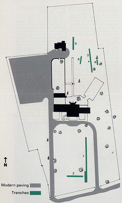
A primary concern for the archaeological team was whether or not enough remained below ground of Richard and Annis Stockton’s ca. 1765 garden to warrant restoration. Previewing a site by test trenching makes good sense; as a tactical procedure, it allows the archaeologist to gain some preliminary knowledge of what is buried below ground and hence helps her to organize and plan an excavation strategy. Clues to the ca. 1765 garden appeared immediately in the first trenches of 1987. In the north yard, 160 ft from the house, excavations in Trench 3 uncovered the edge of a wide set of fieldstone steps that provided passage from the main terrace to a lower level of the garden at the northeast corner of the main parterre (Fig. 8). The findings in Trench 4 confirmed continuation of the terrace fall line across the garden to the west, while Trench 6 revealed that the third terrace did not extend to the east.
Thus in 1987 one corner of the garden was established; without further information on the other boundaries, however, the formal plan of the garden could not be delineated. One way to approach that problem was to locate the original house. Gardens are normally attached to houses, and the way a house is placed on a lot can help determine the garden’s location. Similarly, the dimensions of an 18th century mansion’s front and side walls were often used to forth the primary rectangle in the network of geometric rectangles employed in garden design (Paca-Steele and Wright 1987). By using the proportions drawn from the house, a repetitive pattern was embedded in the landscape that tightened or enhanced the linkage between the two parts, making the whole more pleasing to the eye. The pattern also emphasized the centrality of the house, whose symbolic meaning was both denser and had higher priority than that of the garden. An 18th century garden served as an embellishment to the main dwelling house, which symbolized the family and its generational continuity and strength.
Searching for the Original House
The problem at Morven was that no one knew the proportions of the original house or precisely what damage had been done to it during the Revolution or whether it had survived two centuries of Stockton occupation. One of the instructions in the archaeological mandate from the New Jersey State Museum therefore was to search for evidence of fires that might have damaged the property in the late 18th century. To date, such evidence consists of burned building rubble dating to the 1770s off the west wing. Beneath the rubble lie materials from an earlier era (Fig. 9). No burned materials were found adjacent to the main block.
During the National Park Service’s architectural survey of 1987-88, Peggy Albee found that all construction evidence surviving above ground in the fabric of the main block was consistent with a building date of about 1795. That is, the present main block at Morven should be associated with the household of Richard “The Duke,” not with that of his father. If the main block was built in the 1790s, several decades after Richard and Annis Stockton’s garden was laid out, then it was of little use to us in reconstructing the original garden. Its dimensions could hardly have been repeated in the earlier garden. Hence much of the 1988 field season was spent trying to unravel the mystery surrounding the form and placement of the original Stockton house.
In 1988 we excavated a horizontal area outward from the main doorway on the south side of the house in search of clues to the location and configuration of the original building. Speculation included the opinion that the west wing was the original house, a much smaller and simpler domicile improved upon by later generations; oral tradition maintained that the west wing was the kitchen, and this was, in part, supported by the architectural evidence of a large fireplace and shed (Albee 1988; Grieff 1989). It was hard, however, to see any relationship between the plan of the west wing and the elaborate fieldstone steps 165 ft to the north and 132 ft to the east of the wing. We kept enlarging our area of excavation, trusting that the information that would enable us to tie the stone steps to a definable garden plan would emerge once we had located the original Stockton home.
By the fall of 1988, the archaeological evidence indicated that the extant main block was built upon an earlier foundation which dated prior to the Revolution. Further, it was also evident that within that time frame (1755-1775) the present west wing stood in association with the main block. Evidence for a standing east wing in the 1780s/1770s was scantier, and consisted solely of a segment of the north cellar foundation wall—a wall that was much thicker than the other cellar walls known to have been constructed ca. 1850 by Commodore Robert Stockton. Through the use of “peekholes” cut into the fabric of the building, Blaine Cliver and Peggy Albe of the National Park Service determined that the north wall of the east wing was incorporated within and built prior to the ca. 1850 addition.
Using a Cultural Model from the Past
In the spring of 1989, after a winter of working in the crawlspace of a 1950s addition to the house, archaeologists turned their attention once more to the garden on the north side of the house. Excavation above the northeast stairs revealed an east-west fieldstone walk whose continuation to the west was verified by additional 5 by 5 ft units (Fig. 10). This walk joined a 19th century north-south walk slightly east of the stairs. Subsequent work revealed that, as was the case in the front yard, an earlier 18th century fieldstone walk existed beneath the 19th century walk. Testing for a’ north-south walk in line with the extant north door revealed another fieldstone feature, more ramplike than the stairs, slightly to the west of and just off center from the central axis of the main block, connected with an axial garden walk.
Perhaps the greatest breakthrough in understanding the garden came with the decision to consider the main block and two wings, rather than just one, as the essential element comprising the exterior facade.
Summary as of December 1989
Understanding and being able to use the geometric grammar adapted by 18th century men and women for the design of their gardens brings us one step closer to recovering the context of the earliest Stockton garden, but it is not sufficient in and of itself. There are other things to consider—especially horticulture—not all of which could be touched upon here (see, however, Yentsch et al. 1987; Miller and Yentsch 1988; Miller et al. 1990). The exploratory work at Morven is drawing to a close; renovation of the gardens under the direction of Dr. Rudy Favretti began in the summer of 1990. While renovation proceeds, phytolith (microscopic mineralized plant remains) analysis based on the previous seasons of field archaeology is also underway. It should provide new data to add to the list of plants grown at Morven as defined by the documentary record.
The renovation itself, in its design, will use segments from all of Morven’s gardens rather than just the 18th century garden described here. This is appropriate: Morven today is the sum of all the people who lived within its walls and all the ways in which they sought to transform the past or make use of its symbolic potential. Telling the story of how they did so is the task of any good museum charged with maintaining and transmitting the cultural history of its people. Morven, neglected for short segments in its past, is now a museum “jewel in the making” and one in which historical archaeology has played a major role. It is, perhaps, one of only three fully studied 18th century American gardens (along with Monticello and Bacon’s Castle) in which substantial features, planting beds, tree-holes, and garden plantings have been subjected to intensive, scientific archaeological scrutiny and thereby made to reappear.
The View of Morven as of December 1990
In January 1990, shortly after this article was written, a new governor took office in New Jersey. Within 10 days, his Secretary of State had dismantled the Morven project and implemented new plans to use Morven as a gubernatorial guest house. The artifacts were removed from the Morven archaeological laboratory and placed in deep storage in a Trenton warehouse by state archaeologists who were not members of the Morven team; the building was closed to the public. Professional archaeologists employed at Morven and other Morven staff were terminated, and by the end of June 1990 none remained. Other archaeologists from the New Jersey State Museum staff and from the Department of Transportation, with help from prison laborers, filled in the excavation units in late June. No plans now exist to prepare any field report or complete any inventory of the artifacts, and there are no plans to raise funds, public or private, for these necessary stages in the archaeological discovery process. In essence, the landscape archaeology project at Morven no longer exists.
The original plans for the project called for three years of exploratory research and then for concentrated work on a final report in subsequent years (Yentsch 1988; Yentsch, Bescherer, and Kratzer 1990). This report would have contained detailed information on all facets of the research project. We deeply regret that work was halted before the orderly process of excavation and report preparation was complete, but the decision, made at the highest levels of New Jersey state government, was one that none of the archaeologists had any control over or influence upon.
-

- Spiral fieldstone garden feature of unknown function located at Morven in 1989.
-

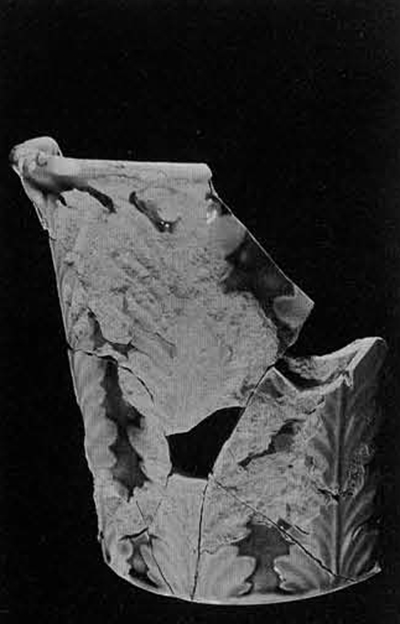
- Other horticultural artifacts.