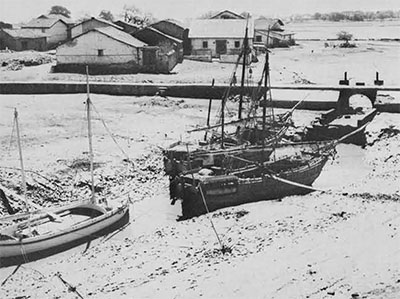
Until recently it was generally believed that the Indus civilization was land-locked and its limited trade route leading to Mesopotamia and Elam lay along through Baluchistan and southwestern Iran. It was even said that there was hardly any sizable international trade which could have intensified the cultural activity of the Indus people. Recent explorations have, however, brought to light several Harappan ports giving a coastal aspect to the Indus civilization and suggesting a brisk sea-borne trade between the Indus people and the Sumerians in the late third and early second millenniums B.C.

Harrappan Ports
In the course of a rapid survey of the coast line of Kutch, Kathiawar and South Gujarat undertaken by the writer during the years 1954 to 1958, several Harappan settlements came to notice, most of them being ports situated at the mouths of the rivers. Todio is a small Harappan port on the southwestern coast of Kutch which afforded shelter to the ships plying between the Indus estuary and the Gulf of Cambay in the second millennium B.C. Amra and Lakhabawal are two other ports situated near Jamnagar on the northwestern coast of Kathiawar, while Kindarkhera near Porbander, Prabhas (Somnath) near Veraval, and Kanjetar near Kodinar are on the main trade route. They are important estuarine ports of the late Harappa period on the western coast of Kathiawar.
The earliest, and the most important, sheltered harbor, which the Harappans developed into a large emporium and servicing station, is Lothal (22 degrees 31’N; 72 degrees 15’E). Situated as it is at the head of the Gulf of Cambay in the estuary of the Sabarmati and Bhogawa rivers, it was the warehouse of the rich rice, cotton, and wheat-growing hinterland. The inhabitants exported agricultural and marine products and imported the raw materials such as gemstones and metals, needed for domestic consumption and for supplying the processing industries which sustained a large population. Farther south are Megham and Bhagatrav, two other Harappan trading stations situated respectively at the mouths of the rivers Narmada and Kim.
Thus, the entire coastline of Kutch, Kathiawar, and South Gujarat, covering a distance of 1,400 kilometers, was studded with Harappan ports in the second millennium B.C. Some were already established as early as the third millennium. George F. Dales, who surveyed the Makran coast, has located a new Harappan port at Sotka-Koh on the Pasni estuary. That site lies 130 kilometers, to the east-southeast of Sutkagen-dor, the westernmost Harappan settlement which, he thinks, was also a port four thousand years ago. Obviously, both settlements must have been maritime trading stations.
Land or Sea Route
Some scholars have suggested that the Harappans might have taken a land route to Kathiawar from Sind via Desalpur in Kutch and Rojdi in Central Saurashtra. Recent excavations have clearly established that Desalpur was a small HArappan settlement which borrowed certain elements (such as the stud-handled bowl and coarse grey ware) from Lothal and certain others from Mohenjo-=daro. Sri K.V. Soundararajan, the excavator, has assigned the early levels of Desalpur to about 2000 B.C., which would be contemporary with phase IIIB of Lothal A and the early levels of Rojdi, both of which have been dated by the Carbon-14 method. In this connection it may be mentioned that the two cultural periods, A and B, of Lothal represent respectively the mature and the degenerate (or late) Harappa cultures. Period B consists of structural phase V while the earlier period A consists of phases I through IV, numbered from the bottom up. Below Lothal IIIB, dated 2010 – 115 B.C., lie five structured levels: IIIA, IIC, IIB, IIA, and I. Hence the Lothal port must have been occupied by Harappans a few centuries before the two inland settlements at Desalpur and Rojdi came into existence.

Kanasutaria and Sujnipur, two inland sites situated northeast of Lothal, are assignable to the Transition Phase of the Harappa culture and must have come into existence a few centuries after the mature Harappa phase ended at Rangpur and Lothal. Hence, they cannot be considered as intermediary stations on a nearby land route taken by the Harappans on their southward march from Sind to Kathiawar. In fact, no inland station of the Harappa culture is as early in date as Lothal. Farther south of Lothal is an early Harappan port known as Bhagatrav. Its situation supports the view that the Harappans moved along the coast to South Gujarat.
In a paper in Lalit Kala(nos. 3-4, New Delhi, 1957) I have shown that the Harappans came by a sea route to Kathiawar in two waves. The availability of a good sheltered harbor at Lothal which provided access to the hinterland and the possibility of controlling the sources of raw materials were sufficient to attract the seafaring merchants of the Indus Valley. They made a peaceful penetration, lived together with the local inhabitants, and established in due course inland stations at Koth, Rangpur, Rojdi, etc. This initial colonization took place in the latter half of the third millennium B.C. The second wave came in the beginning of the second millennium as a result of a catastrophic flood in the Indus and other rivers, which destroyed most of the towns and villages and forced the inhabitants to move to safer regions. Some of the refugees from the lower reaches of the Indus escaped to Kitch and Kathiawar and made temporary settlements at Todio, Kindarkhera, Prabhas, Kanjetar, Mehgam, and other estuarine ports. These are termed ‘late Harappan’ ports as distinct from such ‘early Harappan’ ports as Lothal and Bhagatrav. Further exploration of the coast may bring to light many more Harappan ports. It can thus be safely assumed that in both periods the Harappans took the sea route.
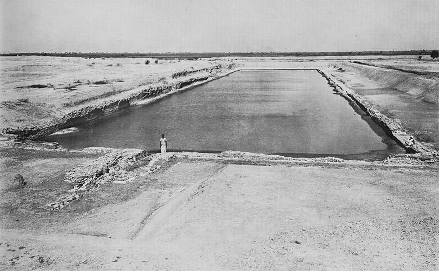
Lothal: The Dock
One of the important results of the excavation of Lothal is the welcome light it has thrown on the maritime activities of the Indus people.
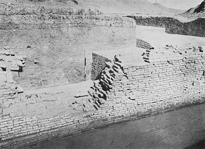
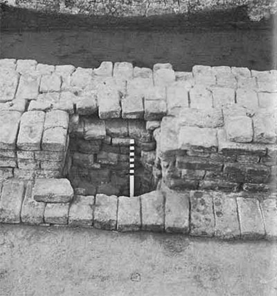
The largest structure of baked bricks ever constructed by the Harappans is the one laid bare at Lothal on the eastern margin of the township to serve as a dock for berthing ships and handling cargo. It was built in phase IIA about 2300 B.C. It is trapezoid in plan with brick-built walls enclosing an excavated basin. This basin was fed with water through an inlet channel, the excess being allowed to escape through a spillway, whose western and eastern embankment walls are on an average 214.87 meters long, and its southern and northern walls 37.26 meters, while their extant height is 3.30 meters. Originally, they must have been higher still, flush with the wharf built adjoining the northern wall. The walls are 1.60 meters wide at the foundation level and 1.30 meters at the top, except in the reconstructed patches which are only 0.75 meters wide. The inner face of the basin is absolutely vertical without any sort of access. On the outer face of the brick walls three offsets are visible. Originally, there was a 12.21-meter gap in the northern embankment wall which served as an inlet for ships entering the basin at high tide.
The ships reached Lothal from the Gulf of Cambay through the estuary of a river flowing along the western margin of the town and entered the dock through a gully running east-west on the northern margin. Before our work in 1961 tracing the original flow-channel of the river (first stage) and the gully, it was thought that ships had had access to the basin from the very beginning through the eastern embankment wall. The excavations showed that the inlet located in the eastern embankment was provided in phase IV to sluice ships into the dock through an inlet-channel of the river (second stage). The need for this inlet-channel was due to an unprecedented flood which blocked the mouth of the river and silted up its original flow-channel on the western margin of the town. The inlet of the second stage is 7.02 meters wide and the channel only 1.5 to 2 meters deep and the inlet gap 7.02 meters wide. But originally, the dock was designed to sluice ships 18 to 20 meters in length and 4 to 6 meters in width through the 12.21 meters-wide inlet gap in the northern embankment. At least two ships could pass through the inlet simultaneously.
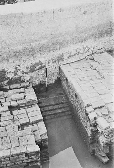
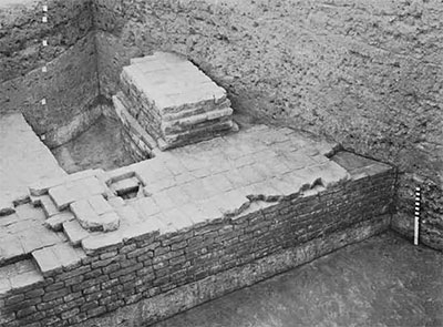
Maneuvering was also easy in the early stage as ships entered through the shorter (northern) arm of the dock, whereas, in the post-flood days they had to enter through the longer (eastern) arm. It may be pointed out that the country craft plying nowadays between Malabar and Gujarat with a draft of 1.5 to 2 meters and weighing as much as 60 tons enter the ancient dock at Gogha which is still in use. The width of this dock is only 10 to 15 meters. On this basis it can be safely assumed that ships weighing 40 to 50 tons could easily have entered the Lothal dock through the inlet (second state) in the western embankment even after the river changed its course. The original builders of the dock had taken necessary precautions to counteract the water thrust by providing offset on the outer face of the brick walls, and by increasing the thickness of the western wall where the thrust was greatest. The wall was further supported by a mud-brick wharf, 13 to 20 meters wide. The northern margin of the town was protected against scouring action of the gully, through which ships had to be sluiced, by a massive wall of kiln-burnt bricks. At the mouth of the inlet-channel (second stage) brick walls were built on either side to protect the inlet against scouring. A spillway was built in the souther embankment to allow excess water to escape. The high degree of engineering skill achieved by the Lothal folk can be understood from the ingenious way in which they could regulate the flow of water into the dock at high and low tides. They could ensure flotation of ships in the basin by sliding a door in the vertical grooves of the flanking walls of the spillway at low water. Excess water was allowed to escape by keeping the spillway open at high water. In no other port of the Bronze Age, early or late, has an artificial dock with water-locking arrangements been found.
In fact, in Indian itself, hydraulic engineering made no further progress in post-Harappan times. The dock at Gogha, an early historical port on the Kathiawar coast, south of Lothal, which is in use even today has a spillway but no water-locking arrangement. It is always kept open to ensure automatic ;de-silting. The boats get stuck at low water and flotation is not possible. Obviously, the water-locking arrangements made by the Harappans were not followed in the early historical period in other ports.
The occurrence of stone anchors in the basin of the Lothal dock indicates that ships were anchored with the help of stones. They were occasionally tied to wooden posts as indicated by the presence of postholes. The position of the anchors indicates the floor level of the basin and allows a calculation of the depth of the water. The height of the existing embankment wall is 2.5 meters high, but was originally more. Hence, the maximum depth of water available in the basin must have been at least 3 meters. The height of the water column above the sill of the inlet in the first stage was about 2,5 meters. It is therefore reasonable to suppose that ships with a draught of 2 to 2.5 meters could enter the dock at high tide through the inlet in the northern embankment (first stage). Later on, it is only smaller ships with a draught of 1.5 to 2 meters that could enter through the inlet in the eastern embankment (second stage).
Anchors
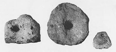
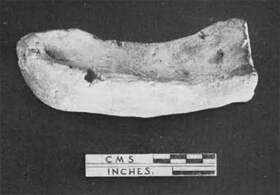
Of seven stone anchors found at Lothal five come from the dock and one each from the gully and the acropolis. Four anchors are of limestone, two of sandstone, and one of miliolites. Six of them are spheroid in shape and one is triangular in plan with a rectangular section. The latter has a hole at the apex but none at the base. The Egyptians and Phoenicians are said to have used round and triangular ones from which wooden sticks projected so as to keep the anchors engaged in the sand. In each of four of the six spheroid anchors form Lothal there is one large hole in the center and two smaller ones used for fixing the wooden sticks which engaged the anchors in sand or silt. Two other anchors have only one large hole each. From these details it is clear that the sailors from Lothal used two types of anchors. The first type with three holes was a composite one, while the second type with a single hole was a rock anchor.
Boats
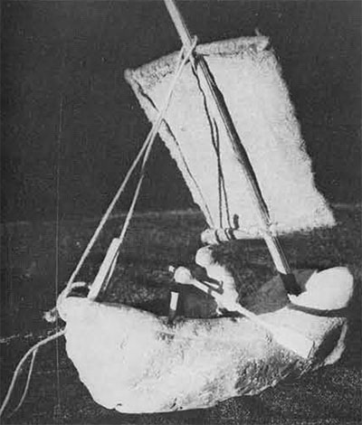
Unfortunately, no remains of actual boats have been found. The shape and other details of the boats used can only be inferred from clay models. of boats and paintings on potsherds. Three different types of boats can be seen in the five terracotta models found at Lothal. The only complete specimen available represents a ship with sail. It has a sharp keel, a pointed prow, and a blunt stern. A hole visible near the stern was used for tying a rope when the ship had to be towed or secured to a wooden post. It could also be used for fixing a mast. The socket on one of the sides was either used for securing the sail or for resting an oar against a peg. A second type of boat is represented by a single specimen. One of its ends is curved the other is damaged. Perhaps both the stern and the prow were curved as in the case of the Egyptian boats of the Gerzean period (before 3100 B.C.). A single hole a little away from the center of the floor was meant for fixing the mast. Unfortunately, the prow is damaged. The keel is pointed and the sides are raised.
The remaining three models, all damaged, form a distinct group with flat bottom and pointed prow. Possibly the stern was not pointed. No holes are found in any of the three models. Apparently, they represent barges without sails as used on rivers and creeks. The first two types having a sharp keep with provision for sails represent ships which plied on the high seas. They could enter the dock in the first stage only. In the second stage, flat-bottomed canoes and barges were used for bringing cargo from the ships berthed in deeper waters. A fourth type of boat is suggested by the paintings executed on two potsherds recovered in the excavations. The type is similar to the multi-oared boats of the late Gerzean period in Egypt. At least 36 pairs of oars are indicated in one case, while in the other the total number cannot be ascertained as the sherd is damaged, although it too must have been a multi-oared boat.
Cargo and Trade
The non-availability of fine-grained siliceous stones in the alluvial belts of the Indus and Sabarmati Valleys necessitated their importation from elsewhere. Mohenjo-daro and Lothal must have imported agate and chert respectively, from the Narmada Valley and the Sukkur-Rohri region. As Chanhu-daro and Lothal were two important centers for bead-making, they imported agate and carnelian and produced beads on a large scale.
In addition to bead factories, workshops of coppersmiths have been excavated at Lothal. The occurrence of bun-shaped ingots with 96.46% to 99.8% purity at Mohenjo-daro and Lothal suggests that copper was imported from overseas sources, among which may be counted Susa and Oman. Bun-shaped ingots have been found at Ras-al-Qala and a few other sites in the Persian Gulf islands. The ingots from Susa and Mohenjo-daro contain arsenic as one of the impurities whereas the ingot from Lothal does not contain any arsenic, even in traces. It is, therefore, likely that Lothal and Mohenjo-daro obtained their supply of copper from two different sources.
That there was a far-flung trade in copper as late as the latter half of the second millennium B.C. is suggested by the shipwreck recovered by the University Museum expedition near Cape Gelidonya off the Turkish coast (Expedition,Vol. 3 no. 2). Copper and bronze ingots of oxhide and bun-type were among the cargo of that ill-fated ship of the Late Bronze Age. According to Oppenheim the clay tablets from Ur indicate that sailors returning from Dilmun offered a share of their cargoes including gold, silver, copper, lapis-lazuli, stone beads, ivory, inlays (of shell), pearls, wood, and eye-paints to the Goddess Ningal. It is said that whereas in the Akkadian period (about 2350 B.C.) ships came from Magan and Meluhha, during the Third Dynasty of Ur (about 2100 B.C.) no ships came from Meluhha. During the Larsa period (about 2000 B.C.) Dilmun merchants acted as intermediaries, thus monopolizing the trade with Ur. Most of the evidences of foreign contact in the form of Reserved Slip Ware, copper ingots, a bull amulet of bronze, clay impressions of stamp seals, and the Persian Gulf seal found at Lothal relate to the Akkadian or slightly earlier period but not to the Larsa period. As most of the square seals of Indus origin found at Ur, Kish, and Asmar come from the Akkadian levels, it is reasonable to suppose that Indian ports had direct contact with the Sumerian ports in the Akkadian period but not in the periods after the Third Dynasty.

The principal exports of Lothal were ivory, shell inlays and ornaments, beads of gemstones and steatite, and, perhaps, cotton and cotton goods. Bhal, the alluvial flat wehre Lothal is situated, has long been famous for its cotton. The Kathiawar coast abounds in conch shell. The raw material and rejected pieces of shell found in the factories outnumber the finished products, suggesting that shell was worked for export. Lothal was also an important center for ivory-working. That elephants were reared here is indicated by the occurrence of elephants’ tusks and femurs. The minute details of its anatomy depicted on the sealings are further evidence of intimate knowledge of the animal. From a merchant’s house in the bazaar street, shell bangles, two Indus seals, eight gold pendants similar to those found in the Royal Cemetery at Ur, and sherds of Reserved Slip Ware were recovered. Obviously he was engaged in trade with foreign countries.
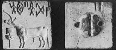
Several writers have referred to the occurrence of Indus seals at Ur, Susa, Kish, Asmar, Hama, Lagash, and Tepe Gawra. Of eighteen seals of Indian origin from Ur listed by C.J. Gadd in an article in The Proceedings of the British Academy in 1932, fifteen are circular, two cylindrical, and one squarish. The circular seals must have come from Bahrein where upwards of two hundred seals of this type have been recovered recently by the Danish expedition. The circular seals from Ur are presumed to have belonged to Indian merchants who lived in the Persian Gulf islands and traded with merchants at Ur. The cylindrical seals from Ur which bear Indus motifs may also have belonged to the Indian merchants living at Ur, the reason for this supposition being that each region had its own distinct type of seal–circular in Bahrein, cylindrical in Mesopotamia, square in the Indus valley and Kathiawar. The circular seals found in Bahrein have been assigned to the Akkadian and pre-Akkadian periods by the current Danish Bahrein Expedition. The circular steatite seal found at Lothal is almost identical with the seals from the Akkadian levels of Ras-al-Qala in Bahrein.
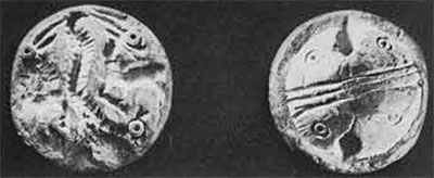
Two terracotta sealings from Lothal are significant. One bears impressions of a seal with a swastika motif drawn in multiple lines in the same style as the seals from Susa, Brak, and Sialk. The other bears a compartmented square design similar to the one on the seals from Sialk and Susa. Other articles of Indus trade such as cubical stone weights and square steatite seals of Indus workmanship travelled as far north from Ur as the Diyala region. A cubical weight has been found in Tepe Gawra stratum IX-X (about 3200 B.C.). Among other sites where Indus weights are found ar Kish, Ur, and Susa.
Plain and etched carnelian beads as well as wafer beads of steatite which are of undoubted Indus workmanship have been reported from various sites in the Tigris-Euphrates Valley. Etched carnelian beads are found at Susa, Ur, Troy, Hissar, Kish, and Tell Asmar between 2500 and 2000 B.C. Among the more significant artifacts of foreign origin found on the Harappan sites, mention may be made of hut-shaped and compartmented steatite vessels, a bronze amulet with a couchant bull figure reminiscent of those from Susa, and pins of copper of bronze with animal- or bird -heads. Lothal has produced two beautiful copper dogs closely resembling one from Susa. The ceramic evidence is also of considerable importance. The Reserved Slip Ware found at Mohenjo-daro and Lothal is identical in fabric and treatment to the ware from the Sargonid levels of Ur, Brak, and the Diyala region. It is said to occur in the Early Dynastic levels also in the Diyala region. A terracotta head of a bearded man with Sumerian features from Lothal suggests contact with the West. Trade regulations between Egypt and Kathiawar are suggested by two terracotta figurines, one resembling a gorilla and the other a mummy, both found at Lothal.
SUGGESTED READING
George F. Dales, Jr., “A Search for Ancient Seaports,” Expedition, Vol. 4, No. 2, 1962.
S. R. Rao, “A ‘Persian Gulf’ Seal from Lothal,” Antiquity, Vol. 37, pp. 96-99 and Plates 9, 10, 11. Cambridge, England, 1963. Also articles in current numbers of Ancient India, edited by A. Ghosh. New Delhi.
Sir R. E. M. Wheeler, The Indus Civilization (Supplement to the Cambridge History of India). (Second Revised Edition.) Cambridge, England, 1960.
S. R. Rao obtained his M.A. from Nagpur University in 1946. He entered the service of the Archaeological Survey of India in 1949. As Superintendent in the Western Circle, Mr. Rao discovered thirty sites of the Indus Civilization in Gujarat, among which Lothal is the most important. He was field director of the excavation at Lothal from 1956 to 1962; and has also excavated Rangpur, a Harappan site in Gujarat and Kaveripattinam, an early historical port on the east coast in South India. At present, he is excavating Paiyampalli, a southern Neolithic site. Mr. Rao’s report on the excavation at Rangpur appeared in Ancient India, Nos. 18 and 19.