-

-
The Voyage of Captain Bellinghausen to the Antarctic Seas 1819-21 … The Hakluyt Society, London 1945.
“Breakfast with the King of Otahiti“
-

-
The Voyage of Capitan Bellinghausen to the Antartic Seas 1819-21 … The Hakluyt Society, London. 1945.
“View of the Coral Island of Moller [Amanu, Tuamotu Archipelago.]“
-
-
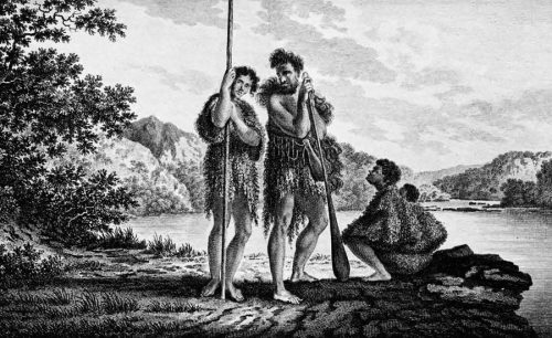
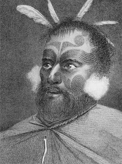
Family in Dusky Bay, New Zeland.
James Cook, A voyager towards the South Pole, and around the world … in the years 1772, 1773, 1774, 1775. London 1777.
-

-
James Cook, A voyager towards the South Pole, and around the world … in the years 1772, 1773, 1774, 1775. London 1777.
“The Landing at Mallicolo [Malekula], one of the New Hebrides.“
In previous articles we have considered various discoveries made by five nations–Holland, Spain, Britain, France, and the United States. There is still a sixth country to be heard from–Russia.
!["Natives of Ono Island [Ono-i-lau, Fiji Islands]."The Voyage of Capitan Bellinghausen to the Antarctic Seas 1819-21 ... The Hakluyt Society, London 1945.](http://www.penn.museum/sites/expedition/files/1959/05/natives-ono-island.jpg)
The Voyage of Capitan Bellinghausen to the Antarctic Seas 1819-21 … The Hakluyt Society, London 1945.
!["Natives of Grand Duke Alexander Nikolaievich Island [Rakahanga, Cook Islands]"The Voyage of Captain Bellinghausen to the Antarctic Seas ... The Hakluyt Society. London 1945.](http://www.penn.museum/sites/expedition/files/1959/05/Natives-grand-duke.jpg)
The Voyage of Captain Bellinghausen to the Antarctic Seas … The Hakluyt Society. London 1945.
The most famous Russian navigator to traverse the South Pacific was Otto von Kotzebue, but most of his fame came from his Arctic explorations. The Russian navigator who made the most new discoveries was Admiral Thaddeus Bellingshausen, so I shall consider his voyage.
Bellingshausen’s journals have been translated into English and published in two volumes by the Hakluyt Society, under the title, The Voyage of Captain Bellingshausen to the Antarctic Seas 1819-1821. He sailed from Kronstadt in 1819 and explored in Antarctic waters until the weather drove him north to Australia, New Zealand, and finally into Polynesia. Most of Bellingshausen’s discoveries are in the Tuamotu Archipelago, for which he sailed with an avowed purpose:
“…Thence I intended to continue, after passing to the east of the Society Islands, between the part of the ocean which Roggewein called the “Stormy Sea” and the Dangerous Archipelago, discovered by Bougainville. These names, so unpleasant to the nautical ear, have caused ships to avoid all these seas and therefore I counted upon finding islands or shoals as yet undiscovered…”
Bellingshausen was a brave man to take sailing ships into the Tuamotuan waters strewn as they are with low atolls, reefs, and shoals; since their discovery they have become a vast graveyard for ships of all kinds. The first island he came upon was Amanu, discovered, unknown to him, by Andia y Varela in 1774, who named it “Isla de Las Animas.” Bellingshausen says:
“…I called this island ‘Moller Island’ in honour of Vice-Admiral Moller, under whose flag I had commanded the 44-gun frigate Tikhvinskaya Bogoroditza…”
(Thank goodness he didn’t name the island for the frigate!) His next discovery was Angatau, which he named “Count Arakcheev,” and on the next day, July 12, 1820, he found “Prince Volkhonski Island,” better known today as Takume. Close by was Raroia which he called “Field-Marshal Prince Barclay de Tolly Island.” (Raroia received further fame not so long ago when the Kon Tiki raft crash-landed on its reefs.)
St the next island he located he had considerable contact with the natives and learned their name for it–Nihera, which is now usually spelled Nigeri or Nihiru. Oddly enough, the natives he found there were probably visitors, too, since the island does not now and may never have supported permanent inhabitants.
After Nihera came “Lieutenant-General Yermolov Island,” identified by one source as Makemo, and by another source as Taenga (or Holt), which is more likely. Actually, both of these islands had already been discovered although Bellingshausen didn’t identify them as such. They were found in 1803 by John Turnbull and John Buyers, in the British ship Margaret (which gave her name to Nukutipipi, one of the Duke of Gloucester group.) Turnbull had named Makemo “Phillips Island” in honor of the sheriff of London, Sir Richard Phillipps, and Taenga was named “Holt.” It “Yermolov” is identified as Taenga, then the next island Bellingshausen came to was Makemo, which he named “Prince Golenitschev-Kutuzov-Smolenski Island.”
Southwest of Makemo Bellingshausen found Tepoto (not to be confused with another Tepoto in the Tuamotus) which he called “General Raevski Island.” This name, Raeffsky, is now applied to a group of three islands close together: Tepoto, Hiti, and Tuanake. In 1840, when the United States Exploring Expedidtion, under Charles Wilkes, was surveying the Tuamotus, this group was renamed “Seagull Islands” after one of the ships in the expedition and the individual islands were renamed “Chute,” after the quartermaster (Tepoto), “Reid” (Tuanake) and “Bacon” (Hiti) after Passed Midshipmen. These names are not commonly used, however. After Raevski, Bellingshausen found Katiu which he entitled “General Graf Osten-Saken Island.” His next discovery was Tahanea which he called after Admiral Chichagov (or Tchitschagoff) who had commanded the Russian fleet at one time in wars against Sweden, From Tahanea he had sighted Faaite (Bellingshausen’s editor identifies it as Fakarava, but this seems unlikely to other authorities); this island he named “Graf Miloradovich” (or Myloradowitch) after a man who gained fame during the evacuation of Moscow before Napoleon’s army, Another Russian military figure who was involved with Napoleon was commemorated at the next island: this is probably Fakarava, and Bellingshausen named it “Count Wittgenstein.” Of his next find, Niau, he says, “I called this island, discovered by us, after ‘Vice-Admiral Greig,’ under whose command I served in the Black Sea.” His last discovery in this area was Matahiva which he named “Lazarev” (or Lazareff, Lazaroff, or Lazarov) after the captain of the Mirnyi, his second ship.

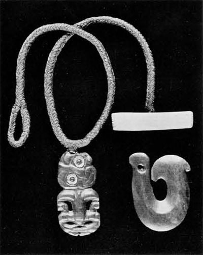
Penn Museum Objects: P3123 and P2318
After Bellingshausen extricated himself from the Tuamotus he sailed east and north and found an uninhabited atoll which he named Vostok after his own ship. Vostok is now classified as one of the Line Islands–a number of small, widely scattered, isolated islands that are assigned a group name more for convenience sake rather than geographical considerations. Although Vostok is nothing but a coral lump, less than a mile square, it managed to accumulate a number of names: Stavers, Reaper, Leavitts, and Anne. On August 7, 1820, he sighted Rakahanga, in the northern Cook Islands, and decided to call it “Grand Duke Alexander.” (Mendana may have originally discovered Rakahanga for he gave some island in its vicinity the name “San Bernando.” In 1822 an American, Capt. Patrickson, thought he had discovered it and called it “Reirson”; similarly, Capt. Joshua Coffin, i the U.S. whaler Ganges, called it “Little Ganges” in 1828.
Sailing on, he missed the Samoan Islands but entered the Fiji group and encountered two small islands which he named “Mikhailov” (after the artist in his expedition) and “Simanov” (after his astronomer, who was a professor at Kazan University). These islands, in the Southern Lau group, are now known as Tuvarna Ira and Tuvana Itholo, their native names. His most important find in the Fiji Islands was Ono (Ono-i-Lau), actually a group of six (ono means six) islands surrounded by one reef. On the western side of Ono he saw the reef on which his ship had nearly been wrecked at night and he named it “Beregis” or “Take care” reef. (It is now known as Vatua Ono–Ono’s child). From Ono, Bellingshausen sailed for Sidney and the Antarctic again. He had been a modest man and named none of his discoveries for himself; however, his compatriot, von Kotzebue, on his second voyage honored him by naming the northwesternmost of the Society Islands Bellingshausen (they are also called Motu One).
To summarize Bellingshausen’s wanderings and namings together with other names: In the Tuamotu or Dangerous Archipelago:
| Amanu: | Moller, Amanou |
| Angatau | Count Arakcheev, Arackcheef, Araktchev, Ahangatiu, Fangatau, Ahangatou, Aatao, Maroupa |
| Takume | Prince Volkhonski, Wolkonsky, Wolkonski, Takoume, Takurea |
| Raroia | Field-Marshall Prince Barclay de Tolly, Barclay de Tolly |
| Nihiru or Nigeri | Nihera, Niheri |
| Taenga | Lieutenant-General Yermolov, Yermaloff, Jermaeloff, Holt |
| Makemo | Yermolov?, Prince Golenitschev-Kutuzov-Smolenski, Koutousoff, Phillips, Makima |
| Tepoto | General Raevski, Ofiti, Eliza, Chute, Maurua |
| Katiu | General Graf Osten-Saken, Saken, Katiou |
| Tahanea | Admiral Chicagov, Tschitschagof, Tchitchagov |
| Faaite | Graf Miloradovich, Myloradowitch |
| Fakarava | Count Wittgenstein, Fakarawa |
| Niau | Vice-Admiral Greig, Fa-aau |
| Matahiva | Lazarev, Lazareff, Lazaroff, Lazarov, Mataiwa |
In the Line Islands: Vostok: Vostock, Wostok, Stavers, Staver, Reaper, Leavitts, Anne. In the Cook Islands: Rakahanga: Grand Duke Alexander, Grand Duke Alexander Nikolaievich, San Bernando, Reirson, Little Ganges, Rakaanga, Rokahanga. In the Fiji Islands: Tuvana Itholo: Simanov, Simonov, Tuvana i tholo, Tuvana-i-tholo; Tuvana Ira: Mikhailov, Mihailov, Michaelov, Tuvana ira, Tuvana-i-ra; Ono: Ono-i-lau; Vatua Ono: Beregis, Bereghis, Take care, Vatuo Ono Vatua Ono.
He proposed the title “Russian Islands” for the central and northern Tuamotus where he and others of his countrymen had made many discoveries, but his title never came into general use since the Tuamotus are one long chain of islands fairly close together and not readily divisible into geographic groups.
After perusing a detailed map of the various island groups many people, including myself, have wondered how it was that the early navigators sailed very close to some islands without ever seeing them, or else discovered one island and completely missed an adjacent one. Bellingshausen, for example, discovered Rakahanga but apparently never saw its sister island of Manihiki, only twenty-one miles to the south. He was off Rakahanga most of two days and one night in very good weather, he charted the island quite adequately, and most of the time stood off the southern extremity of it. However, both of these islands are low coral atolls (tree top elevation for Rakahanga is given at sixty feet and Manihiki is probably about the same) and cannot be seen from each other. This is only one example of a miss; there are many others, some of which involve high volcanic islands. Of course one can think of several obvious explanations of why explorers missed seeing islands they were close to: the weather was often an important factor, telescopes were not nearly as high powered then as they are now, and ships were not as large as most modern ships and were consequently much lower in the water.
One historian, G.C. Henderson, was not content with the past explanations and decided to experiment for himself. He was doing research for his book The Discoveries of the Fiji Islands and over a period of years he sailed among the Fijis (presumably in a motor-powered boat) duplicating as close as possible the conditions under which the explorers saw the islands. He followed the same courses, waited for comparable weather conditions, approached islands at the same time of day. His observations are very interesting and tend to exonerate the early navigators of those charges often leveled against them, of timidity, lack of tenacity of purpose, poor seamanship, inadequate reporting and charting, and purposeful misrepresentation.
Henderson writes:
“My third reflection was that, though the information given by these commanders in their charts and log-books may frequently be at variance with actual facts, it is nevertheless a true account of what they saw. It is well known to us, and was, no doubt, to them, that evidence of the senses is often misleading at sea; but as they ploughed their way through uncharted waters they had little or no time to make minute examinations. They had to trust very largely to their senses. The fact that their charts often differ very materially from modern charts does not mean they were careless or incapable men; it means rather..that, quite frequently, things are not as they seem to the voyager passing by. The sketch of the coast of Viti Levu [Fiji Islands], taken by Midshipman Langdale on the Pioneer on May 8th, 1789, resembles the sketch on Bligh’s little chart much more closely than a modern British Admiralty chart. The Admiralty chart is true to fact; the sketches by Mr. Langdale and the Lieutenant Bligh are true to what they saw from that station point.”
Perhaps we should not wonder that the early explorers missed islands which might have been hidden by haze or clouds or other islands, or charted reefs which don’t exist because light from the moon shining on the ocean through rifts in the clouds suggests the appearance of a line of breakers; perhaps we should only wonder that they discovered some of the islands at all. And we can still marvel that they had names for all of them.
!["Man of the Island of Tanna [Tana, New Hebrides]"](http://www.penn.museum/sites/expedition/files/1959/05/man-island-tanna.jpg)
The Russians, as we have seen, tended to honor famous military figures and their royal family. At first glance I thought the Russians could recieve credit for commemorating a musical composer; Otto von Kotzebue, in 1817, gave the name “Rimski-Korsakoff” to one of the Marshall Islands, either Ailinginae or Rongerik. However, the famous composer wasn’t bor until 1844 and the island was actually named for one of Kotzebue’s lieutenants. There seem to be no names honoring musicians–there is no Bach or Beethoven or Haydn or Handel or Purcell Island. It would seem that, as might be expected, the South Pacific mariners were not men of the arts; neither are there any great artists honored (although a number of islands were named for the official artists on the voyages), nor is there a Voltaire or Shakespeare or Pushkin Island.
Certainly the principal name-giving tendency of the British was to dignify their discoveries with the names of royalty and the peers; they were, naturally, quite partial to the lords of the Admiralty. There are, for example, six dukes: Clarence, Gloucester (twice), and York (three times); there is at least one earl (Earl Dalhousie Shoal in the Carolines), and King George III was honored twice. Brigham lists four princes but only one is English–Prince of Wales in the Torres Straits. Turning to the lords, there are at least seven–Hood, Howe, North, and Salisbury, Howe being remembered four times; I believe they are all for the same Lord Howe who happened to be the First Lord of the Admiralty during the main period of English exploration. British captains also liked to name islands for their expedition members and often rewarded the man who first sighted the island by naming it after him.
Museum Object Number: CIVIC1993.X.1559
It might be expected that since these voyages were so long (usually two years or more) the women they left at home would be very much on the minds of these navigators. However, either they didn’t consider their women important enough to name an island for, or they were sailors in the popular tradition and forgot about the ones they left behind. Anyway, whatever the reason, there are not too many islands with feminine names (if one excludes the Santas). There are five Elisabeths, three Elizas, two Janes, and one Sue. There seems to be only one Mary, Mary Balcout, which is now called Canton Island; I think it was named after a ship (which, of course, may have been named for a wife or daughter) as was at least one of the Elizas. Caroline fared better; besides the large group of Caroling Islands there is a Caroline in the Line Islands. Only two queens seem to have made it, and they wer Charlotte and MAria Anna, (Mariana Islands) widow of Philip IV of Spain. It helped if the wife was along: Freycient, a French explorer, named Rose Island in the Samoans for his wife who was with him at the time.
However, women shouldn’t be hurt if they weren’t remembered too often–they can think of how the Joneses must feel There are at least three Smith Islands but not a single Jones I could find!
In naming islands the Americans, as usual, were rather eclectic. Like the Dutch they sometimes remembered place names at home (New York, Massachusetts, Nantucket), and like the French they sometimes remembered themselves (Fanning). Mainly, however, they seem to have followed the British tradition of naming islands for public figures (Washington, Adams, Madison). America’s biggest effort in Pacific exploration was the Wilkes Expedition (officially the United States Exploring Expedition) between 1838 and 1842; it was, in fact, the largest of all Pacific expeditions, and it was also the last one of any importance. Admiral Charles Wilkes had six ships under his command and their purpose was to discover, explore and chart other discoveries, and make scientific collections. They did make a number of new discoveries, and charted a number of old ones, especially in the Fiji and Tuamotu Islands, most of which they renamed. They adopted both the British and French tendencies to name islands after themselves; in fact, I think Wilkes must have gone down the muster roll of his expedition (officers and scientists first) when he handed out names. Few of them, however, stuck.
Of course there are many exceptions to these national tendencies (if such they are) in selecting names. The Spanish could be descriptive: one island, whereabouts now unknown, they named “Sin Puerto” because it had no port. The Portuguese, Ferdinand Magellan, called the Mariana Islands, “Islas de las Velas Latinas” (Islands of the Lateen Sails) but his officers called them “Islas de los Landrones” (Islands of Thieves) because the natives stole from them. The Dutch occasionally named islands for people: Tasman named what is now called Lihir, off the coast of New Ireland, for a member of the Council of India, but his intentions were better than his spelling for he referred to it as “Gardenys” and “Gerrit de Nijs” on the same page of his journal (it has also been spelled Gardenijs and Gerrit Denys). Both the British and the French gave descriptive titles: Cook called the Tonga Islands the “Friendly Islands” because the natives were so nice to him (other navigators, to their sorrow, found this to be a misnomer) and Bougainville named the Samoan Islands “Isles des Navigateurs” because he was so impressed with the native canoes.
There were two things all of the namers-of-islands seem to have had in common: the navigators, no matter what their nationality, rarely forgot to honor their ships by naming an island after them, and many of them had a tendency to be repetitive with their names. Examples of repitition have been given before and there are many more: there are three Danger and one Dangerous (the Tuamotus); five Disappointment, five Goat (plus one Spanish one–Cabras), nine Green (including one Dutch Groene Eylanded), and three Sand, one Sands, and two Sandys (plus three Sandwich, all named, I suppose, like the Hawaiian Islands, for the Earl of Sandwich).
So far, we have been concerned only with the names given to the islands by their European discoverers. However, practically all of the islands in the South Pacific had been found long before the Europeans by the Polynesians, Micronesians, and Melanesians. Let’s have a look at what the native inhabitants called a few of their islands.
It seems that they, too, were repetitive. There are at least four Motuiti in Polynesia, and the name simply means little island, or islet. There are three Pukapuka, but I don’t know what that name means.
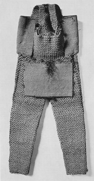
Museum Object Number: P3297
The Polynesian Maori probably discovered New Zealand sometime around A.D. 1000. They gave it a descriptive name–“Aotea roa,” or “The Long White Cloud” for this is what it is supposed to have looked like as they approached it in their large sea-going canoes. The Maori have a myth (which I have taken from Sir Peter Buck‘s book, The Coming of the Maori) to account for the discovery of New Zealand and the naming of the two main islands. It seems that one of their gods, Maui, who was the youngest of five brothers and was always getting himself into trouble, stowed away in a canoe one day when his brothers went on a fishing expedition. When he was discovered he assumed command of the canoe and sailed it into unknown waters far south and west of their home (presumably some place in the Society Islands). Finally Maui selected a place to fish, but since his brothers would not share their hooks with him, he had to use the lower jawbone of his grandmother (which he just happened to have with him). He tossed this overboard and caught a huge fish–the North Island of New Zealand which was therefore called “Te Ika a Maui” or “The Fish of Maui” or “The Canoe of Maui.” The South Island was also named “Te whai Pounamu” or “The Place pf Greenstone” since it is from the west coast of this island that the Maori obtained jade which they carved into tikis and other ornaments, and from which they made fine adzes and chisels.
Tales of the famous Maui are found all over Polynesia; he was sort of a culture hero and a trickster–almost the Till Eulenspiegel of the Polynesians. The second largest of the Hawaiian Islands is named for him.
The Tuamotu Islands, which have been mentioned quite often, derive their name from Tua, meaning ocean or open sea, and Motu, meaning islet, so the composite name can be translated Ocean-of-islets (Tua has also been translated as cloud or bunch, so Tuamotu could mean Cloud-of-islets). An alternate name which is often used for the Tuamotus is Pa’umotu which means Shoal-of-islets. A number of the individual Tuamotuan islands have been considered, especially those discovered by Bellingshausen. Many of their native names can be translated into English, according to Teuira Henry’s list in Ancient Tahiti:
Amanu–Float-away, Angatau–Keep-back, Takyme–Beat-pulling, Raroia–Leaning, Nihiru–Hasty-beauty, Taenga–Arrival, Makemo–Slipping-out, Tepoto–The short. An alternate name is Maurua–Hold-two, Katiu–Young coconut, Tahanea–Siding, Faaite–Show, Fakarava–Make-dark, Niau–Coconut-frond. An alternate name is Fa’aau–Agree. Matahiva–face-of-company, Nukutavake–Advancing-fleet.
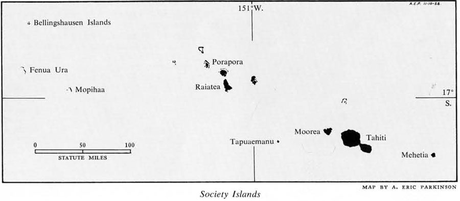
In the Society Islands there are also a number of names which have been translate by Teuira Henry. The principal island, Tahiti, is translated as To-take-to-the-border; sometimes the natives also called it Hiti (Border) or Tahiti-nui (Great Tahiti–a name that is now used often to refer to the main part of the island while Tahiti-iti or Little Tahiti refers to a small peninsula). West of Tahiti is Tapuaemanu (or Tapu-a-manu or Tubuai-Mani) which means Sacred-to-the-birds. Two more of the islands discovered by Wallis are Mopihaa or Mopelia, which means With-springs, and Scilly which was once called Pu-tai–Sea-cluster of Birds-there–but which is now called Fenua Ura (whose translation I can only guess at: Fenua means land and ura may mean to dance or to burn, or ‘ura means red and red feathers, once a sign of royalty).
Moorea, close to Tahiti, proves that the Polynesians, like the Europeans, sometimes gave an island more than one name. The name Moorea (properly spelled Mo’orea) is probably used most commonly now and means Offshoot; however, an alternate name Aimeo (or Aimeho or Eimeo) is still in use and it means Eating-in-retreat since this island was considered the retreat of fugitive Tahitian warriors. There is a poetic name for it too–Aimeo i te rara varu–or Aimeo of eight radiations, since the mountains divide it into eight natural divisions. Perhaps for the same reason it was also referred to as Fe’e or Octopus. Furthermore, it might also be called Tahiti-iti or Little Tahiti. Two more of the Society Islands, both discovered by Captain Cook, also have more than one name: the island now called Raiatea (Clear-sky) was earlier known as Havai’i or Invoked-space-that-filled and is identified in mythis as the home or source of all the Polynesian peoples. The other island is Porapora (or Borabora or Bolabola) which means Firstborn since in traditional legends it was the next island created after Havai’i, it was famous as a place of brave warriors, hence its poetic names Porapora-i-te-how-manu, meaning Firstborn-of-silent-paddle, and Porapora-i-te-nuu-ta-rua, meaning Firstborn-of-the-fleet-that-strikes-both-ways. Its ancient name was Vavau.
The Micronesians, like the Polynesians, often seem to have named their islands for legendary events. For example, Ponape, in the Eastern Carolines, means On-the-altar and refers to a creation myth wherein two brothers pulled the island from the ocean to serve as an altar. The Micronesians, too, gave their islands names that are descriptive of natural features and that are poetic. Abaiang and Abemama, two atolls in the northern Gilberts, can be translated Land-in-the-Wind and Land-of-Moonlight.
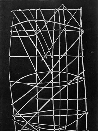
The Micronesians and Polynesians resemble each other in many ways. Culturally and racially they are much closer together than either is to Melanesia. There are linguistic affiliations, too, especially between the eastern islands of Micronesia (the Ellice group particularly) and Polynesia. The islands of both areas, whether they are volcanic islands or coral atolls, can be described as small in comparison with many of the islands of Melanesia. Generally speaking, the islands in both areas are “grouped” with large spaces of empty water between the groups (this is, of course, much more pronounced in Polynesia). Polynesia, as a whole, is a remarkably homogeneous area in culture and in language; Micronesians exhibit more differences between each other but still are relatively homogeneous in contrast to Melanesia. The first two share another characteristic–that of being excellent mariners with boats capable of long sea voyages, and with highly developed techniques of navigation when out of sight of land (like the Micronesian charts made of sticks and showing not only land but also currents and wind direction). In their views toward the “outer world” (that is, to other islands), the peoples of both areas might be called internationalists.
I have pointed out these similarities because in contrast to them the Melanesians might be called isolationists. As a unit, a culture area, Melanesia doesn’t hold together very well: it is quite heterogeneous in race, in language and culture, and in geography. It would be incorrect to speak of the New Guineans, meaning the native people of New Guinea as a unit, as one can speak of the Tahitians. There are (literally) an unknown number of tribes in New Guinea separated spatially usually by mountains and separated otherwise by culture and language. The same situation exists on such other large islands in Melanesia as the Solomons, New Britain, and New Caledonia. Contact between these little pockets of people was usually restricted to highly formalized trade arrangements (often “silent trade”) or to warfare. They were aware of their immediate neighbors, but in many cases their view of their world was a restricted one.
Perhaps this explains why many islands in Melanesia had no native name. A tribe had a name for the particular valley or area in which it lived, and for adjoining areas too, but not for the islands as a whole. To give an example, the native name for the large island of Santa Ysabel in the Solomons is often listed as Mahaga or Bugotu, but actually Mahaga is a single village in Bugotu, which is only a district in Ysabel. This probably explains why the names given to these islands by Europeans have so often been retained, whereas in Micronesia and Polynesia native names have tended to re-assert themselves and are used much more commonly now. Codrington, an early anthropologist, in his book, The Melanesians, discuss this peculiarity of the Melanesians; he says that a visitor inquiring the name of a particular island may have been given the name of the village or section, or that of an islet between himself and the mainland, or even the name of a man of the place to which he pointed! Thus, San Cristoval was called “Bauro” by Europeans, but this is only a name of a part of it, and a village on the same island was called by the name of its chief and not by the native name for it. Florida was called “Anutha,” because, pointing to it from the deck of his ship, Bishop Patteson, in 1862, asked a native boy its name and that is what the boy gave, but actually the name belongs to a small islet between Mboli and Ravu.

Not only were the Melanesian tribes not very friendly with each other, but groups within a single tribe were also not always congenial. One of the characteristics which many of the Melanesians do share is a hostile, secretive attitude toward others. Codrington records that natives sailing between islands often wished to conceal their destinations from either real or potential enemies, so they used circumlocutions to refer to other islands. Some of these are: Mota (Sugarloaf Island) was known to a certain group of people as Ure-kor (the place full of dried breadfruit); Ureparapara (full of slopes) or Bligh Island was Ure-us (full of bowls); and Ure-kere (full of clubs) was a synonym for Merlava (Star Island or Star Peak). All of these islands are in the Banks Islands, a group in the New Hebrides.
Thus we have come the full round: from islands with too many names to islands with no names. Finally, the name of the ocean where all of these islands are might be considered. The story is told that the first European to see it was Vasco Nunez de Balboa and he took possession of it for Spain and named what he saw from the shores of Panama the Golfo de San Miguel. Fernao de Magalhaes, to give him the proper spelling, the first man to sail around the world (he really didn’t–he was killed in the Philippines–but his expedition did) named the ocean Mer Pacifico because it was such a contrast to the rough and stormy Atlantic he had just crossed. Long before Magellan the Polynesians had named the ocean in honor of Kiwa, the mythological guardian of the ocean. The Polynesian Maori called it “Te-moana-nui-o-Kiwa,” The Great Sea of Kiwa.