Presented to the Museum by the Honorable John Wanamaker
As all the world knows, Robert Louis Stevenson lived and died in Samoa. His love of adventure led him in 1890 to make a voyage on the steamer Janet Nichol among the islands of the South Seas. During this voyage, accompanied by Mrs. Stevenson who in 1914 published an account of the adventure, Stevenson visited the Marshall Islands, at that time a German colony and now in the possession of Japan. From the islanders he obtained a very fine example of the native chart, a device which has proved a mystery and which has baffled all students of navigation and of primitive invention. Such charts are to be found in various museums of the World, and the example which Stevenson obtained from the Marshall Islands in 1890 is now in the possession of the University Museum.
Mrs. Stevenson, in her book The Cruise of the Janet Nichol, gives the following passage from her diary of the voyage.
“These charts are very curious things, indeed, made of sticks, some curved, some straight, caught here and there by a small yellow cowry. The cowries represent islands, the sticks both currents and winds and days’ sailing. The distances between the islands have nothing to do with miles, but with hours only. These charts are very little used now, only one old chief knowing how to make them, but the time was when each young chief must pass his examination in the charts, knowing them by heart, as they were never taken to sea but kept at home for reference and continual study. Louis and the commissioner and Captain Brandeis (a political refugee from Samoa) tried to make out the names of the islands by comparing the charts with our European map, but failed; a man who had been thirty years in the islands was consulted, and afterwards a native, but still they were baffled. It was finally settled that the thirty year resident should see the maker of the charts (now absent) and get a complete key to be sent to Samoa.”
The Marshall Islands are composed of two chains of atolls or coral reefs, there being fifteen atolls in one chain and eighteen in the other. On the laths of which Stevenson’s chart is composed are written in pencil by some one whom he employed to do it, the names of twenty-six of these islands. Some of these names are placed in localities not now marked by shells and it is possible that some of the cowries have become detached. The handwriting may be that of “the commissioner” or of “the thirty year resident” mentioned by Mrs. Stevenson. The writing would indicate a German hand.

Museum Object Number: P3297
Image Number: 244789
In Mrs. Stevenson’s brief account of the nature of the Marshall Islands chart there is hardly a clause which is not contradicted or at least considerably modified by statements made by others who have attempted to explain the nature and use of these curious aids to primitive navigation. Three attempts have been made to explain how the charts were used, but the most elaborate explanation leaves the reader with hardly any clearer an idea than may be gathered from the simple statements quoted above from Mrs. Stevenson’s book.
Although there is so much contradiction among writers there is no room for doubt that the cowry shells tied to the sticks represent particular islands. Comparing the Stevenson chart (Fig. 15) with a map of the Marshall Islands (Fig. 16) it will be seen that there is a close correspondence between the positions of the shells on the laths and the positions of the islands with relation to each other, which proves that the native chart maker intended his shells to represent islands of the group.
The meaning of the various sticks is not so clear nor so easy to explain. In Mrs. Stevenson’s statement “the sticks represent currents” we have the popular explanation, but the matter is in fact somewhat complicated. In the Marshall Archipelago during the season of native navigation there are four distinct swells setting from the four quarters of the sea. For each of these swells the native has a distinguishing name. The behaviour of these four sets of swells complicated by their impact on the atolls engages close study on the part of the native navigators. They have thus developed an art of navigation which has its terminology and its conventions, and is based upon close observation of the behaviour of the swells, the conditions of the wind and sailing time. A chart, such as this of Stevenson’s, attempts to indicate by the curved sticks the direction from which come the ocean swells (called on the chart “currents”), and by the straight sticks the line of waves caused by the impact of two colliding swells. Such a line of toppling waves is called an okar. According to this chart, then, a canoe sailing from Jaluit to Majuro would proceed north by the pole star until the okar (straight line) for Majuro was encountered, and then turn to proceed along that to its goal.
Mrs. Stevenson’s statement that the sticks represent also winds and days’ sailing can be confirmed at least in part, but about the number of persons who still understood the use of these charts she was evidently misinformed.
It is stated on good authority that every chief had his own system for preparing charts and this system was a secret which he kept strictly to himself. In these islands the chiefs held extraordinary power. Supernatural qualities were attributed to them; they were priests as well as kings, monopolists of special knowledge no less than of political power, leaders in all enterprises, including the voyages of fleets. As noted above, the preparation of the charts, regarded as an important accessory to the navigator’s craft, was a secret art ; and it was protected by a tabu.
The first brief account of the use of the stick charts to reach the civilized world was furnished by the missionary, Dr. Gulick, in 1860. It was obtained through the wife of a chief, who, in spite of her position, was threatened with death for disclosing even the few details which Gulick published.
On the authority of a certain Don Luis de Torres, then living in Guam, the poet Chamisso, who visited the South Seas in 1817, says, concerning the natives of Mea and the neighboring Caroline Islands, that the steersman of a boat used to lay down in front of him a little stick by which he believed himself to be guided. Have we here the germ of the Marshall Island charts, and the true secret of their employment and of the tabu? There is much open water between the Marshalls and the Carolines, but we know that there was communication. The Marshall Islanders are reputed the most daring seamen of the South Seas; a voyage of 600 miles is on record. Dr. Hahl, governor at Ponape, wrote to Schück (1900): “In the eastern Carolines . . . the natives use aids [to navigation] similar to those of the Marshall Islanders.”
Chamisso, knowing of this magical compass of the men of Mea, whose sole efficacy lay in the confidence of the pilot that he was guided by its straightforward painting, visited the Marshalls also, but makes no mention of any form of stick chart there. If he had seen one, the connection could not have failed to strike him and be recorded. Kotzebue, commander of the ship on which Chamisso sailed, speaks of the skill of the Marshall Islanders in making diagrams with stones in the sand, from which he received information as to the position of various islands in the group. He says nothing of stick charts. We are not told that the pilots concealed the charts themselves from anyone; it was the knowledge of the method of their construction and use that was tabu.
When Kotzebue was there, a chief of the island of Wottho was able to indicate by means of the compass in what direction the nearest island lay. A savage who had never seen such an instrument before would hardly have been able to do this. The islanders have been in contact with the navigators of civilized nations for a long time. Saavedra may have visited them in 1529. Wallis touched at the Marshall Islands in 1767. In 1788 Marshall and Gilbert explored the group. People so keenly interested in navigation as these islanders have always been, would be very likely to acquire early in the period of their intercourse with civilized sailors a certain degree of familiarity with aids to navigation such as charts. Why should not the delineation of currents, etc., on the ships’ charts have suggested to them ideas which led to the elaboration of the simple magically directive stick into the complicated arrangements of laths and shells of which, it is important to note, we have no reports from travelers before the middle of the last century, after nearly a century of intercourse with this region of the Pacific?
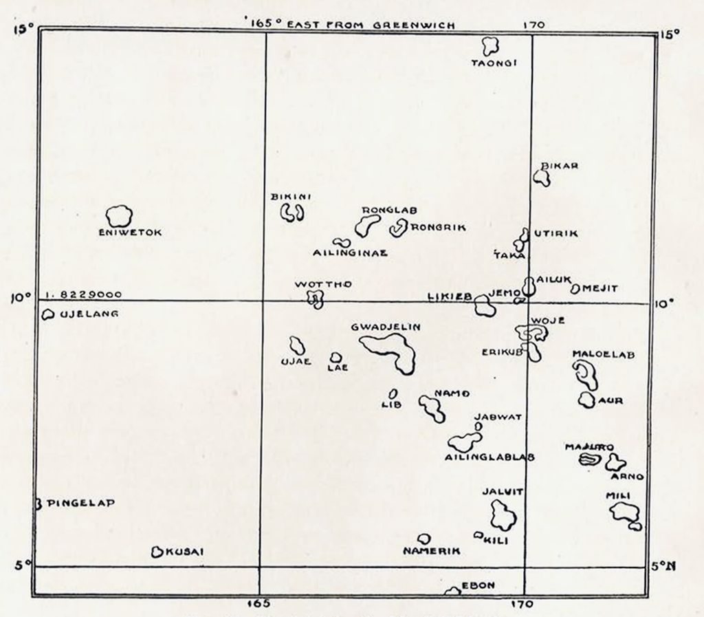
Image Number: 244789
It is natural to believe that these people, to whom seafaring has for so long been a necessary condition of existence, should have accumulated a considerable fund of sea lore, of circumstances and conditions which would render their voyages from island to island comparatively safe. The observed direction of drift of particular canoes, the direction from which the rollers came to break upon the encircling reefs of their atolls at different times of the year, the observation of patches of cross seas occurring here or there—all this and other bits of relevant information would accumulate slowly through the long generations while men were learning by many mishaps how to avail themselves for their advantage of the forces which at first drove them blindly from one haven to another unsought. So they would get some notion of what water conditions they might expect to encounter in certain quite vaguely delimited regions at certain seasons. With the help of the more constant stars and the steadier winds, they could shape for their fleets—in voyages out of sight of land a number of canoes always sailed together —a course which would bring, with fair certitude, some of the flotilla at least into sight of the goal for which all were making. Their leaders, endowed with more than human skill in the reading of sea signs and the knowledge of the stars (for astronomy, too, was a science tabu to the general), carried, it may be, some talisman of lath, the symbol or instrument of their divine directive power.
Now comes a foreign chief, skilled in longer sea voyages, bearing strange accessories of a more effective magic. He shows his seamarks on paper, figures of islands, for which, lacking pens, the islander, both in the relatively advanced Marshalls and in the more backward islands of Torres Straits, has long been accustomed to set stones in the sand or shells on a flat board. But the foreigner sets other sea marks also in his picture, the meaning of which he cannot make so plain. The islander too knows such marks, he will set them down in the material at his hand, linking shell to shell with twigs by which to remember the paths he has learnt upon the waters.
Thus he builds up an elaborate mnemonic system out of his simple materials, until the twig he carried in less sophisticated days becomes a labyrinth of crossing ways, and so large that it has to be left at home when he sets out upon a longer voyage. For, we learn, the larger charts, the rebelib, at any rate, were not taken into the canoes. The Stevenson chart is 49 inches long and 29 wide. An object of this size would be very much in the way in a small canoe, and many rebelib are larger than this. They were studied at home; some were made for the special instruction of those who would later be chiefs and leaders of fleets; all would be merely aids to memory from the purely practical side, but things to be revered as symbols and repositories of a knowledge regarded as occult and banned to common men.
To suppose that men in boats whose gunwales or outrigger platforms are of less height above the general surface of the water than that of the waves among which they sailed, should at any given moment have range of vision enough to embrace any recognizable portion of a swell, to be able to say, as their commentators imply, “At this point (looking over the side) I will put about; just here I must go (consulting his chart) from this line to that to strike the okay just there “—this is to give too much credit to a primitive seaman’s ingenuity. Doubtless he credits himself, sincerely enough, with some such supernormality of vision and of instinct. A case in point has been recorded by Mr. W. Churchill, who by study of their speech has traced many of the longer wanderings of the people of Oceania, and has sympathetically recorded observations of their life made during a long residence in the South Seas. He speaks of the petulance with which a Marshall’s pilot remarked upon his inability to recognize a sign in the blank waters. By this sign the pilot set a new course for the canoe in which they were sailing but the insistently gesturing forefinger of the initiate quite failed to reveal it to the layman endowed with no præternatural “sixth sense.” What is this but the self deception of the priest of an esoteric cult, whose ability to convince his following is dependent upon the completeness with which he has convinced himself of the reality of his own occult powers?
It seems highly probable that the development of these charts is due to modern foreign influences acting upon simple arts and magical conceptions already in existence; that their principal use was as an aid to memory and, so far as one class of the objects, the matang, or instruction charts, was concerned, as a means for teaching. The restriction of their preparation and employment to the highly privileged politico-religious caste has served to invest them with a kind of mystery, apparently not only among the devotees of the faith native to the islands. Closer relations with sailors furnished with compasses and other accessories of the civilized seaman’s craft have led to the abandonment of these charts by people quick to recognize the practically useful in all that relates to seamanship; they now build and rig for their own use small vessels on European models. It is no longer possible to obtain at first hand any explanation of the principles on which the native pilots formerly constructed these primitive helps to memory; the mystery with which their makers surrounded them, and the fact that each individual had his own principles of construction or his own methods of applying common principles would have made it extremely difficult to obtain any such explanation even if this had been attempted in the days before the art had begun to decline.
H.U.H.