THE sites that I wish to speak of are at least six: Xoch, Chipal, San Francisco, Chichel, Nebaj, Xolchún. Xolchún, the last place I put down, is much the most important of the six. But the order in which I have put them down is not intended to be the order of their importance. It is the order in which you would get to them, as I did, coming from the Atlantic side. Xoch is the furthest east and Xolchún the furthest west.
It is easier to tell you how to pronounce the names of these places than it is to tell you exactly where the places are. Nebaj is the only one you would find on a map. There is no really good map of Guatemala, though some are better than others. A map that has been popular is the large map of Paschke, published in Paris in 1889. Another is Bianconi’s pirated map, also published in Paris. Those maps made no great changes in the old, settled parts of the country, the South and Southwest; but for the northern part, they simply made the older maps look ridiculous. Then there was Au’s map. It was never a popular map, but it had the peculiar merit of distinguishing points that had been astronomically fixed: interior points; the coast was right even on old maps, owing to the charting of foreign admiralties. Then there was Sapper’s map which made improvements in the province of Alta Verapaz. Afterwards came Hendges’s map; and that is the map that I happen to be using. It is dated 1902, published in Washington, by what appears to be a Government office, the Bureau of the American Republic. Hendges’s map is perhaps, on the whole, as good a one as I have ever seen. It evidently takes some account of Sapper’s improvements; and what is important, it lays down the Mexican boundary, determined scientifically by the boundary commission towards the end of the century. It may be supposed that anything on the boundary line is in the right place.
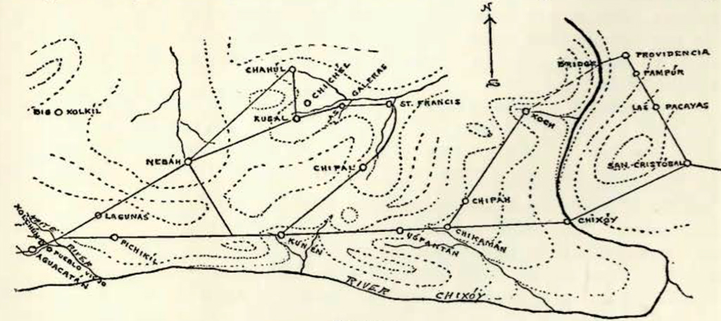
Image Number: 19662
The outside line of the Cuchumatens on the map, the southern line of them that you see running east and west, is placed, I suppose, more or less right. The southern front of the Cuchumatáns is a very definite line; and at any reasonable distance, it is a very distinct line to the eye. At a distance of twenty or thirty leagues, the effect of unity in the long mountain front is very striking. Riding from Quiche to Totonicapan, for instance, you see the Cuchumatáns as a great blue barrier on the north. The barrier seems to be penetrated here and there by black glens. But there is no rift or opening that you can see through. The general appearance is that of a solid frowning rampart rising to a very even height and long stretched out.
You wonder as you look at it what there might be behind. When you get behind that southern front, the face of things is entirely changed. You forget about the front. There is nothing, almost, to remind you of it. For one thing, instead of the bare and more or less desert looking country to the south, what you see now is a green country covered to a great extent with woods. And when you look back south, you do not see anything to remind you of the long mountain range you saw from the other side. There is no definite north front as there is a south front. On the north side, you seem to get into a mess of mountains ramifying in all directions. There are some great mountain masses to be seen and tops apparently
higher than anything on the outside range. And there are endless spurs and ridges and hills behind hills and rivers between. Finally the whole mass—the whole system, I suppose a geographer would call it down to the hot country of the Mexican border and the river Chixoy.
The places are distributed along the southern rim of the eastern Cuchumatáns that you see marked on the map; and the last place, Xolchún, is on the south side of that rim and is the only one of them that is in the province of Huehuetenango, the others being all in Quiche. And when I have said that much, I have said nearly all that it is worth while trying to say, by reference to the map. So I will let the map alone. But I am going to try to tell you about the places and how to get to them, and in so doing, I shall probably give you an idea of where the places are, the same sort of idea that I have myself.
To get to these places you would start from San Cristobal Verapaz. You get there from Panzóa, going up the valley of the river Polochic. There is a little ramshackle railway that goes, not up to Tucurú as the map makes it, but to a point two or three leagues below. From that point on you have to ride. There is a cart road that goes on to Cobán. You follow that muddy cart road and climb up out of the hot country into what is called cold. You pass through the little squalid villages of Tucurú and Tamahú and on and up to the equally squalid village of Tactic, where you would probably stop for the night. The one redeeming feature of the place is that there is a fairly comfortable little inn there. Tactic is where the old road from Guatemala comes in. It was the place selected for an atrocious political murder one night some years ago, arranged something like the death of Mr. Madero lately in Mexico. From Tactic you go on about level. It is nearly always raining about there and you splash through unusual quantities of mud. Two or three leagues on from Tactic, however, you leave the mud and leave the Cobán cart road at the same time. Speaking of leagues, a league is supposed to be five thousand yards of the country and a yard of the country is by law eight hundred and thirty-five millimetres and it works out that a league is very close to four kilometres. It is between two and three miles. But kilometres, and miles even, are too precise for here; leagues are what everybody speaks of. In the Alta Verapaz, on the ordinary bad roads and on an ordinary beast—also bad—you will make about a league an hour. On the cart road you will do a little better. And on the dry roads of the Pacific side you will do about two leagues an hour.
Two or three leagues on from Tactic, as I was saying, you leave the Cohan cart road and take to another cart road that goes off to the left. You will find the going on that road to be a good deal better. The road takes you through an open country sprinkled with trees, scrub oak and pine. Two or three leagues of that and of a sudden almost, as you come around a corner, you see a range of high wooded hills ahead of you in the west. And at your feet, between you and the hills, you see a wide sheet of water with an edge of meadows and marshes. The water is the lake of San Cristobal, the only lake in the Alta Verapaz and a queer place for a lake, on top of a tableland, almost fourteen hundred metres above the sea. The water is always at the same height and is said to be very deep, and it is full of small red fish.
The town of San Cristóbal is at the far shore of the lake; the road goes round the left of the water. The town, as you come into it, is rather a tidy looking little place : a long street round the meadows, by and by some pavement, and finally the usual square with the church facing west and the market in front. San Cristóbal has a pleasant cool climate and it does not rain quite so much as in other parts of the Alta Verapaz. The town was founded, or at least named, by Bishop Las Cases, who seems to have been partial to Saint Christopher. He gave that Saint’s name to several places, including the chief town of Chiapas. The Alta Verapaz town is called for distinction San Cristobal Verapar, sometimes San Cristobal Kahkóh; Kahkóh is the Indian name of the place, probably referring to the lake.
There is a cart road to San Cristobal for the same reason as there is to Cohan, to get the coffee out. San Cristobal is a coffee centre, though on a much smaller scale than Cohan. I daresay it ships [1913] twelve or fifteen thousand bags a year, grown to a great extent on small Indian holdings, and the coffee from that little town gets nearly the highest price in the world. The coffee carts are drawn by oxen and have Indian drivers. They travel slowly. They take a week or more to get down to the railway, depending on the state of the road. When I was in Cobán there were no carts getting in or out. There were about four leagues of mud holes to go through. A cart would stick in a mud hole for a week at a time. Cohan was almost in a state of siege. They were saying, at the time, it was Adrianople. All for want of a little intelligent road mending I The only decent piece of the whole road is that little branch that takes you to San Cristobal, simply because there are fewer carts over it.
San Cristobal is the end of cart roads and of German shops and of regular posts and regular anything, till you get to the other side of the country. From San Cristobal on, the map as I have said, is nearly useless and I have constructed the diagram in Figure A for you instead. The diagram does not pretend to be a map. Roads are represented as straight lines and the course of rivers and contour lines are also merely representative. But as far as distances from place to place are concerned, the proportions, I think, are not altogether misleading. The diagram would probably answer roughly in most distances to a scale of about three-quarters of a centimetre to a traveling league; or one centimetre equals five and one-third kilometres.
The usual road from San Cristobal, going west, and the only public road, is the road that crosses the Chixoy River at the place called Chixoy, about five or six leagues from San Cristobal and about five hundred metres above the sea. The road is down hill, of course, and the latter part very steep. There are also many steep places in the climb up on the other side. But steep places are a matter of course. The public roads as a rule, especially west of the Alta Verapaz, though the natives consider them good, are not really laid-out roads. They are merely improved footpaths and if you have any respect for your beast’s back, you will often get off and walk.
The really vexatious thing about the Chixoy road is that there is no bridge at the river. There have been several bridges, stone and iron, but they have all been carried away. The river is subject to great floods and it is not fordable even when it is down. It is a rushing body of water with steep rocky banks. When the water is especially low, you cross on a raft secured by a rope. At other times you sit in a sling, which is slung from a cable, about thirty feet above the water, and they haul you across in the air. The cable is stretched between two towers, the remnants of a former bridge. Baggage goes in the same way. And your beasts are roped and swum across. It is all very tedious and clumsy; and, in spite of ropes and everything, if the river is high, you are in danger of losing beasts.
I did not come by Chixoy this time. I decided to cross the river at a point about ten leagues or so lower down. I had learned of the existence of some sort of bridge at that point and I understood that by going that way I should get to a place called the Xoch where there were ruins that I had beard of and wished to see. I left San Cristobal, consequently, by the road marked on the diagram as going off to the northwest. The road is a little up hill at first, as far as a hamlet called Las Pacays. My aneroid there marked fourteen hundred and ninety metres. Then you go down hill. You go up and down, but the downs gain on the ups. At the place called Pampur, you have dropped six hundred metres, and down to the river you drop six hundred more, the country getting warmer, of course, all the time.
And there is a sudden change of surroundings a little after you begin to go down hill. You get into the woods and you do not get out of them again till you get to the Xoch. There is a great wedge of forest country that sticks in from the north between the settled parts of the Alta Verapaz and the settled parts of the Quiche, and this road takes you across the small end of the wedge. That forest country is a rainy country. When you can get a look out over it, you are pretty sure to see a shower somewhere. And towards evening, as a rule, it comes on to rain all over. It rained on me the greater part of the way. The road in the woods is a muddy lane between trees. On the way down to Pampur there are only two or three places where you can get a look at the country. When you do get a look, you see that you are going down round a mountain, with the mountain on your left. The mountain comes to an end, in the distance, with the ravine of the river. The far side of the ravine is another mountain, high and steep and covered to the top with woods. That mountain seems to be dead ahead of you, and in fact you have to climb it by and by in getting to the Xoch. That mountain is the most striking thing in sight; but most of the country you Iook out over is to the right of it, an expanse of hills and valleys stretching away to the horizon, west and north. For some distance in that expanse below you, you can trace the hollow of the big river. It seems to make a great turn to the west, not shown on maps. You cannot see the river itself, anywhere, and you cannot make out anything with certainty in what you are looking at. You can not see the face of the ground. It is all nothing but a surface of woods, shadowy and uniform. You cannot tell where anything begins or ends in it. It puts you in mind of Chateaubriand, “La cime indeterminée des forêts.”
There are people living in the woods here and there, though you do not see where until you come on them; Indians mostly, immigrants from the settled parts of the Alta Verapaz, running away from plantation work and the oppressions of the Government or the authorities. They have formed a number of little hives or settlements up and down the river. But they do not very long escape vexation. Somebody buys the land and puts the inhabitants to work; or else they have to run away farther.
One of these settlements is Chamá. Others are Pampur and Providencia, close together on this road that I took. At Pampur there is a waterfall. The water comes out of a hole in the side of a mountain, falls fifty feet or so into a pool, and then disappears into another hole. That limestone country is full of caves and underground streams, and though it is soaked with rain, you may travel leagues and not come to a surface water that you can water a beast at. Evidently the water at Pampur attracted the ancient inhabitants just as it does the modern.
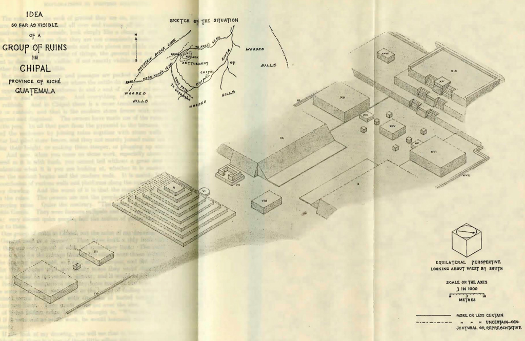
Image Number: 19664
Providencia, as the owner calls it, or Xolyuk, as the Indians call it, is a little further down. There is some coffee and henequen planted. It is owing to Providencia that there is a bridge down below. The bridge is not a public affair. Providencia has men on the other side of the river and the bridge is to get them over to work. The place of the bridge is said to be the narrowest place in the whole canyon of the river. There happened to be rocks sticking up that piers could be built on, and close enough to lay beams. It is a narrow bridge, not meant for beasts, but beasts can cross it if they don’t balk. The only thing to look out for is that there are no rotten cross-sticks. The man at Providencia very kindly sent and had all the bad sticks changed for me, and my animals went over without the slightest trouble.
Very few people seem to know about this bridge, or care to use it if they do know, partly because it is so out of the way for most people but mainly, no doubt, because the road from Providencia to the Xoch is not a riding road. Save a little at the beginning and at the end, the road is a mere Indian mountain trail, steep, like a staircase almost, and being under the woods where the sun never shines, it is a staircase of mud. You can drive a beast over it, but not a load. I got an Indian to take up my pack-mules’ packs and the beasts had nothing but their saddles.
I do not know how far it may actually be from Providencia to the Xoch, probably not far, but it took me about fourteen hours, with very little stopping. You go steep down to the bridge and then immediately up again, up the face of that mountain that I said you would have to climb. You get up to about sixteen hundred metres at one pull, a good deal higher up than San Cristobal is. You don’t go quite to the top. You circle round it, to the south, and then you go down again. You go down a ridge and come to a small settlement called Chi Ritibol which means “At the foot of the ridge.” Then, continuing to circle the mountain, you go up it again to a higher point than before and then, finally, down to the Xoch. If you care for the barometer heights, here they are in metres:
- 860 (Providencia)
- 230 (Bridge)
- 1570
- 1230 (Chi Ritibol)
- 1720
- 1100 (Xoch)
When they finally got to the Xoch, my men shouted for a drink. I don’t mean a drink of water.
The Xoch, or Soch as I believe the owner writes it, is a settlement like Chamá or Providencia, settled by Indians from the eastward. The diagram indicates the Xoch as a valley, and it is a valley, a small fertile valley that lies about east and west and runs down steep to the Chixoy. The north side of the valley is overhung by the mountain you have come round and the south side is a wooded ridge. There is a small coffee plantation in the Xoch. The owner of the plantation and of all the upper part of the valley including the ruins is a well-to-do native, Rafael Cobián, by name. lie lives away in Sololá, however, and never comes now to see the place. The manager is a German and a very obliging chap; he went with me several times to the ruins, took a man with an axe to help, and so on. I was with him several days.
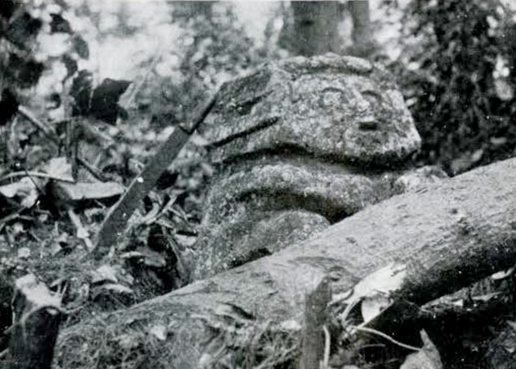
The ruins are up the valley in the bottom, about half a league above the coffee. The height above the sea turned out to be thirteen hundred and fifty metres at the ruins. The place looks like an abandoned pasture, overgrown with bush. The ruins are hidden in the bush. You have to look for them. And you have to look for them with an axe or cutlass. At least, when I was there, you could not get about among them without chopping. There was some talk of having the place cleared for a cornfield, but for the moment it was all a tangle of bush and briars; you could hardly put your hand on a stone. I took one picture (Figure 1) of the carved stone. I had the bush cut away to let in some light and the moss scraped off. The stone is a slab of limestone; there is no carving on the back. The stone is partly cracked, as you see, and a strip on one side, the right side as you look at the picture, seems to be entirely missing. It is one metre forty-four centimetres high and eighty-two centimetres across the middle. It stands at the end of a plaster floor ten centimetres thick, covered of course with earth, and a little to one side of the image, the right hand side as you look, there is a long sunken yard or floor, parallel to the floor of the image, and about two metres lower. That lower floor was about fifteen metres wide in the middle and about forty-five metres long.
I began to take some measurements of the ruins, but I stopped. I could measure the sides of things, here and there, but with the bush I could not see in the least how things stood, the alignments and arrangements of them; and the job of clearing the place, of course, was beyond me. And consequently I have no drawing of the Xoch ruins to give you. But there is no question about the nature of them. They are of that same general nature as the ruins of Chipal or San Francisco, of which I do send you drawings. If you could see a drawing of the Xoch ruins, you would see that they did differ from those others in some points, but only as those others differ between themselves. You would say at once that the Xoch ruins had the family look; and they are of the same order of magnitude as Chical and San Francisco; and there are the same sort of remains of plaster images as in the other places, and the same sort of masonry and workmanship, and even of details of ornament in the masonry. And though the Xoch ruins have not been dug, there can be no doubt but the pots and things you would find in digging would be of much the same nature as what you would find and as what has already been found in Chipal.
Nothing was found in Chipal through any intelligent search. Things were found in the course of demolishing a certain part of the ruins to build a house with the stone. It was only a small part of the ruins that was demolished arid I should suppose that the things already found in Chipal would be only a small part of the whole—whatever you call it, the whole inveniendum, the whole deposit. Anyhow, whatever you suppose the Chipal deposit to be, you must suppose the Xoch deposit to be notably similar.
Besides those principal ruins of the Xoch, there are several smaller ruins in the same valley; and on the north side of the valley there are some caves to examine. Some years ago, a large earthenware image, the manager says, was taken from one of those caves. The image represented a human figure, squatting, I believe; and might have been about half the height of a man as the manager described it. Old Cobián carried it off and has it in his house near Sololá.
Kekchí is the leading language of the Xoch. The language of San Cristobal is Pokomchi, but most people there, both Indians and others, have a working knowledge of Kekchí.
From the Xoch on, the road is a riding road. The Xoch is the edge of the woods. The road from the Xoch to Chicamán, southwest, and from Chicamán straight on west, takes you through a pastoral country, more or less cleared and more or less dry. Four or five leagues from the Xoch, getting up to about fifteen hundred metres, you come to the little hamlet of Chipaj, half a dozen cabins along the road. Asking people at the place, it appeared that a great many things had been dug up there, especially just a few years ago, as the result of somebody offering rewards for such things. I should judge that the things were got in grave mounds disturbed in the course of farm work.
A little further on, and a little lower down, you come to the hamlet of Chicamán, not quite so minute a place as Chipaj. At Chicamán you come into the regular Chixoy road to San Cristobal. Heading west on that road, you get up to the village of Uspantán. Uspantán is a wretched little place about the size of Tactic, and reminded me of Tactic. But it is higher and older, seventeen hundred and fifty metres, about, above the sea. On the north side of the village there is a range of wooded mountains, the eastern end of the Cuchumatáns, and the village is on a swell of ground at the foot of them—a bare, bleak, windy place, in the middle of sheep pastures.
There is a footpath from Uspantán to Chipal, over the mountains; but in order to ride to Chipal, you have to go on west to Cunén and then double back northeast. It is about five leagues to Cunén. All the way you have the Cuchumantán tops on your right. There is a great shoulder that sticks out, and a good part of the way is taken up in skirting it. That shoulder, or salient mountain, as it is, rises to a little peak of its own, which is conspicuous, looking back on it from Cunén; and the Indians venerate the mountain under the name of Wukúb Xikín, or “Seven Ears”. It is curious that there is another mountain of that name in the Quezaltenango neighbourhood.
Running out from the base of Seven Ears there is an important southern spur of the Cuchumantán, and the highest part of the road is where you get over the neck of that spur, about nineteen hundred metres. From there you go steep down, about three hundred metres, to a river, and then up again to Cunén, eighteen hundred metres above the sea, about the same as Uspantán, and consequently in cold country. It is cold enough not only for sheep, which abound, but for wheat. There is wheat grown all along in those uplands and in Cunén there are a couple of small mills. Cunén is not much bigger than Uspantán, but it is in a pleasanter place.
The road to Chipal takes you over the crest of the Cuchumatáns at the lowest point, I suppose, that can be found there, which is about two thousand four hundred metres above the sea. It is not a sharp crest where you go over. It turns out, in fact, to be a tableland that takes you half an hour or more to cross. Then you begin to go down north. And when you begin to go down, you strike the woods again, not the scrub oak and pine that are sprinkled all over the south country, but the old forest that stretches away to the Xoch and away north. You go on down bill and the first big clearing you come to is Chipal, about four or five leagues from Cunén and about the same height as Cunén above the sea. In Chipal you have hills all around you. You seem to be down in a deep bowl. The bowl looks as if it might be a thousand or fifteen hundred feet deep and a league across the top. The bottom is cleared and the clearings go some distance up the sides. Then woods, all round, up to the sky. But the amphitheatre of hilLs is not really closed. I suppose it is something of a horseshoe shape, with the opening towards the northeast, the opening being a deep, winding ravine, that you cannot see down. In the bottom of the amphitheatre, of course, there is a river flowing that goes out through that ravine.
If you look at the Chipal sheet of drawings [Plate XXVII] you will see in my sketch of the situation that the ruins are not near the river or bottom of the amphitheatre, but close to the northwest side, almost overhung by a mountain ridge. A little neck of ground runs out to join a foothill; and the ruins are on that neck. The near end of the ruins, the left hand end, on the paper, is at the foothill end of the neck. The far end is the ridge end, and the terraces or plat-forms at that end are made on the rising ground where the neck springs up towards the ridge. The whole length of the ruins, as you might discover by scaling, is about one hundred and thirty metres.
The ruins, and the neck of ground they are on, are in the middle of a rough pasture, very uneven ground all over and running off into bush. And the ruins themselves, from the outside, look simply like a clump of bush. When you get inside, however, you see that they are not completely choked with bush like the Xoch ruins. The principal yards and wide places are fairly dear—the cattle keep them dear—and the grouping of things, the general idea such as my drawing is meant to show, is fairly visible; if not exactly visible as a whole, it is easy to put together from what is visible.
But nooks and corners and passages are packed with bush; and so are the tops and upper parts of things where the cattle do not get. For instance, the tops and upper parts of the platforms ix and x and of xii and xvi are all bush and the pyramid v, and other things. And everything, of course, is covered with earth and rubbish. And in Chipal there is a more troublesome obstacle than either bush or rubbish, and that is the modern stone fences with which the ruins are disfigured and disguised. The owners have made use of the ruins in past times as a cattle pen. In all that part from the pyramid to the terraces, the owners completed the enclosure by joining ruins together with stone walls—not stone and mortar but piled stone fences, and they not merely joined ruins but overlaid them, raising their height, or making them steeper, or plugging up stairways, or what not. And now, when you come on stone work, especially about the outside and covered as it is with bush, you cannot tell without a great deal of clearing and examination what it is you are looking at, whether it is ancient or modern, or where the ancient begins and the modern ends. It is mainly for that cause that the conclusion of various walls and platforms along the outside is left indeterminate in my drawing. And the worst of it is that the stone for the fencing was taken from the ruins. The owners are not the people to have any compunction about destroying ruins. Quite the contrary. The owner of the place is a Spaniard, Plácido Garcia. They were farmers in Spain and they are farmers again in Guatemala; very decent quiet people, but the notion of preserving ruins would never occur to them.
One group of ruins in Chipal, not the ruins of my drawing but another group, the Garcias used as a quarry. They have built a tidy little three-room cottage that they are very proud of with the stone they took. The ruins of my drawing were not used for the cottage because the others were closer at hand; but the ruins of the drawing were used, as I say, as a cattle-pen, and the owners patched them up for that purpose with any handy stone they could dislodge. The ruins are there to be used, in the owner’s opinion; and it would be a shame not to use them.
Besides the destructive use they have made of the ruins, these Garcías have done some haphazard destruction in the hopes of finding buried treasure. Every Spaniard seems to be born with the idea of buried treasure—the treasures of Mexico and Peru. They never quite get over the idea. When a Spaniard sees one of these Indian ruins, his first thought is, “Whereabouts is the treasure?” And if it were not so much work, he would instantly scatter the ruin to find the treasure.
If you look at my drawing, you will see that in the far square, at each side of the block xiv, there is a row of three little pillars sticking up, the middle one round and the other two square. Now, on the ground there is almost nothing to be seen of those little pillar things except the foundations. You do not see them sticking up. I have represented them as having some height because old Garcia, who showed me over the place, told me that such had been the case before he smashed them. He smashed them, be told me, because it was as easy to smash them as not and there was always the chance of finding the treasure—the money, as he called it in his simple language. And he kept pointing out to me what he considered to be likely spots. Fortunately, these people have not the least knowledge of likely spots and the ruins will take a great deal of battering, too much battering for the owners to think of attempting; and in fact, now, they do not think of it.
Figure 2 gives you an idea of the actual state of things in what I have been calling the far square, or far yard. You are standing somewhere about the near corner of that square, about in the place that is hidden by the top corner of x, and you are looking towards the stairs. You can see plainly the place of the right hand bottom stairs filled with a stone wall to keep cattle in. The affair in the left foreground, covered with bush, is the altar—marked xiv. In the rubbish on the ground, you can see nothing, not even the foundations, of the three little pillars or pedestals that were smashed as possible treasure boxes. But the round white thing you see, with a couple of short legs or feet, stood originally, according to Garcia, on what is represented in the drawing as the round pedestal. That round thing with feet is made of plaster, or rather of stone and mortar plastered over. It is so broken and battered you cannot be sure what it was. It might have been a basin or cistern; in fact, the Garcías called it the font. They call all that part of the ruins the church, the pier xx being the high altar.
Figure 3 shows you what you could see of the box affair marked vii, the same sides of it as the drawing represents. The Garcias call that the castle. There are certain ornaments, I suppose them to be, stuck on the parapet like crenellations and you can see that some of them have holes through them, which struck the Garcias’ fancy as loopholes for shooting through. The box inside is half choked with plaster and mortar rubbish. I have an idea that that plaster and mortar rubbish is the remains of a plaster and mortar image that stood in the box. The box was a shrine. There is a box just like it—or very much like it—in the Xoch, with undoubtable remains of plaster images about it. What the drawing represents as the small block ii would seem to have been the pedestal of a plaster image or of some plaster thing.
The photographs in Figures 3 and 5 show you nearly all the stone work at the ruins that a photograph could give you any view of without a great deal of clearing. In some places there is a good deal of plaster left on the stone. You can see it in the picture on the face of pier xx, and all over the box vii. And the floors are plaster. At least, the whole yard from the pyramid to the terraces has a plaster floor, though mostly covered over with earth.
The group of ruins that the owners built their cottage from is to the west of the ruins of the drawing and within hailing distance of them. It was in that other group of ruins, or in the comparatively small part of them that was demolished for the cottage, that nearly all the pottery and things I spoke of were found. Those ruins are not on any flat piece of ground, like the others, but on a steep slope, the slope of the ridge itself. They are so lost in bush, now, that you cannot make out what they are like exactly. But it is plain they are something quite different from the ruins of the drawing. As you might expect from the nature of the ground, there is nothing like courtyards or aisles; nothing, in fact, adapted to public ceremonies, nothing even that you would call a platform. What there is seems to be a number of cubes or blocks of masonry, higher than a man. The blocks are close together and seem to form two or three tiers on the hillside. The blocks put me in mind, somehow, of those oven graves of New Orleans, only these Chipal blocks are rather bigger things. There is a great deal of plaster about them and they are more or less ornamented in simple ways. In front of one of them, there are remains of plaster statues or images that the Garcías threw down on the chance of finding the money under them.
The pottery stuff, or the best part of it, was come across in a hole or vault—an oven, the Garcías call it—not inside, but underneath one of the blocks. Old Garcia told me about their making the find. He and his son it seems, were there. The son was quarrying and suddenly tumbled into a hole. Then he shouted to his father and immediately began to hand out pottery. They had struck the money at last. And they put their hands into the pots and found only a few beads or bones.
I spoke by chance of the New Orleans graves, but I have an idea that a graveyard of some sort is what those block ruins may be; graves of important persons, perhaps, priests or others, who in life had something to do with the goings on at the ruins of the drawing. That would make those block ruins a very likely ground, I suppose, for the sort of buried treasure that archaeologists are after.
Besides the two principal groups of ruins in Chipal, there are various small outlying ruins. And there is a cave of some interest. The cave is near the ruins, but lower down. In my sketch of the situation, there is a small stream represented as starting near the ruins. The stream comes out of the cave. The entrance to the cave is not where the water gets out, but a few feet higher on the hillside. The entrance is low; you have to crouch. When you get in, you see a big pool of clear water below you, with a sandy bottom, a fine place for bathing on a hot day. The cave is not a big cave, ten metres high perhaps and two or three times as long. You get down to the water by a flight of stones stairs—twelve or fourteen stairs. The entrance, low as it is, is made still more inconvenient by a stone about the length of a man lying lengthwise in the entrance on the floor. The stone may be a natural projection of the floor, but it struck me there was something artificial about it. The entrance is not only low, but narrow, and at each side of it, where you go in, there is a rude human figure about half a metre high or so, sketched on the face of the rock.
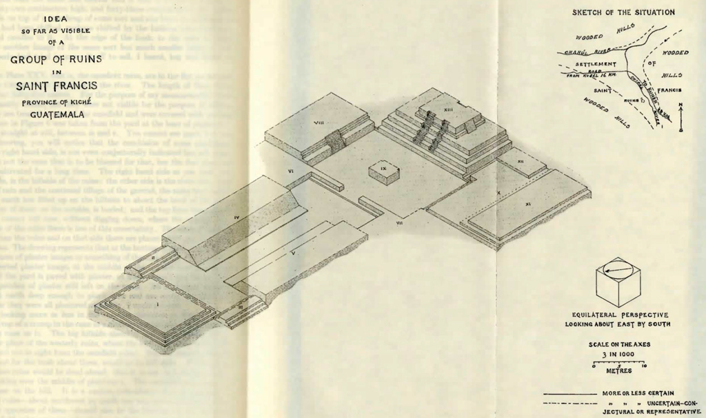
Chipal to San Francisco is down hill two or three leagues on a bad road. In a general way you follow the Chipal River, which you cross twice. On the other side of the river from the ruins, looking across the ravine, you see a few Indian cabins in a clearing and here and there a tree of the forest left standing. From that point you go down again to the river and cross back to the side you started on, the left side. You are then in San Francisco. Just below the crossing, the Chipal River joins the Chajul River from the west, so that you are between the two rivers.
The place of the Chipal ruins is about seventeen hundred and fifty metres above the sea. San Francisco is about eleven hundred and consequently a different climate. You can sleep under a sheet in San Francisco when you need a blanket in Chipal. The thing about San Francisco which has made it a centre of settlement—both now and I suppose anciently—is the junction of the rivers, or rather, the land at the junction, a little fertile flat. Hills rise up steep all around. The owner of San Francisco has turned a great part of the flat between the rivers into a canefield. He makes brown sugar and sends it up to Nebaj on mules. This owner is an Italian subject, Mr. Peter Brol, a very pleasant, sensible man. He does not care a button about ruins or antiquities but understands that other people may, and if they wish to come and explore the ruins on his land, be will be happy to see them come, and if they find any buried treasure they can have it. He even offered to give the men that might be needed. But he probably changed his mind on that point when he understood that the exploration would not be an affair of days but of months.
The San Francisco ruins that I send you the drawing of [Plate XXVIII] are in the canefield on the flat. They were the only ruins I could measure in San Francisco, but they are not the chief ruins. The chief ruins are on the big hillside to the north, on the far side of the Chajul River. They are in a northwesterly direction from the canefield ruins and not far off, about twenty minutes’ walk by the actual round-about path. Those hill ruins are on the hillside but they do not stand on a slope. There is a wide shelf in the hillside not far from the bottom, and the ruins are Iaid out on that shelf about fifty metres above the level of the flat. The shelf is an old clearing and has been used as a pasture, but it is overgrown with bush. I could not see over the ground and could not form an idea of the arrangement of the ruins, but I can say that the extent of ground they occupy is much greater than that of the ruins of Chipal. The ruins seemed to be composed principally of platforms, and the typical platform, not oblong but rather square, eight or ten metres on a side, and the sides vertical. Low blocks of masonry, in fact, are what those platforms are, sometimes two story platforms, an under block and a smaller block on top, but nothing very high, nothing that would be more than, perhaps, twice the height of a man. Some of the walls had the plaster still on them; and there were remains of inserted plaster images or whatever the things may have been. As I could not see the arrangement of the ruins I could not be sure that there was an arrangement, but probably there is. At least there is to this extent, that the blocks that I took the bearings of seemed, as near as I could tell, to be all on the same bearings, all parallel.
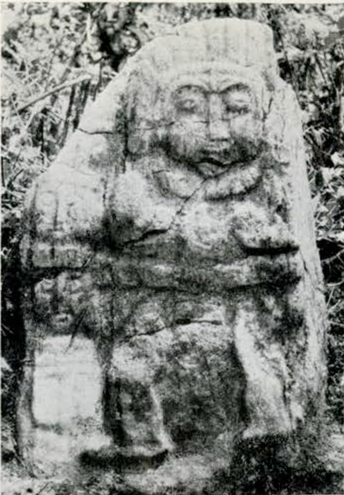
On the same hillside as those ruins but a good deal further west, about half an hour’s walk or more, there are some other ruins. These other ruins are at a little higher level than the first, and the shelf they are on is a comparatively small place. It was cleared of woods at some time in the past, but it is tall bush now, getting to be woods once again. It is impossible to see the ruins except in one or two spots, not on account of the shade but on account of the depth of vegetable rubbish that lies over everything. The ruins do not take up much ground; there is not much ground for them to take up. At one spot, in fact, the ground was not enough; the edge of the shelf is built out with a high wall under it down the bank. It is at these ruins that the stone and mortar idol is that is shown in Figure 1. The idol is seventy-two centimetres high, and forty-three centimetres is the width of the face. It is on top of a ruin heap of some sort and sits loose on whatever is under it as if it had been shifted, perhaps shifted by the Indians who come and burn incense and candles to it. At the edge of the bush, to the west of those ruins, there was another image of the same sort but much smaller lying on the ground. Somebody had tried to carry it off to sell, I heard, but had found it too heavy.
The ruins in Plate XXV, that is, the canefield ruins, are in the flat on the left hand side of the Chipal River and close to the river. The length of them from end to end is about forty-five metres. For the purpose of my measurements these ruins were reasonably visible, but they were not visible for the purpose of taking a picture. They are treated as part of the canefield and were covered with waving cane. The picture in Figure 6 was taken from the yard at the base of platform i. You are looking straight at xiii, between iv and v. You cannot see much but the cane. In my drawing, you will notice that the conclusion of some platforms, especially on the right hand side, is not even conjecturally indicated but left indeterminate. It is not the cane that is to be blamed for that, but the fact that the place has been cultivated for a long time. The right hand side as you look, the southwesterly side, is the hillside of the ruins; the other side is the river side; and with the wash of rain and the continual tillage of the ground, the ruins have acted as a dam. The earth has filled up on the hillside to about the level of the platforms; the bottom of them, on the outside, is buried; and the top lines being much obliterated, you cannot tell now, without digging down, where the outside was. On the other side of the ruins there is less of this uncertainty. The wash of earth is naturally away from the ruins and on that side there are places where you can even see the foundations. The drawing represents that at the bottom of platforms i and ii.
There are traces of plaster images or something of the sort at the altar, marked iv, and of an inserted plaster image, at the middle of the outside bottom step of platform i. And the yard is paved with plaster, at least where I dug for it; and there are many patches of plaster still left on the walls. All horizontal surfaces are covered with earth deep enough to plant cane and are much disturbed by planting; whether they were all plastered originally, I could not tell.
Figure 7 is looking more or less in the opposite direction to Figure 6. It is taken from the top of a stump in the cane at a distance behind xiii, which appears as a mound with cane on it. The big hillside ahead of you is the hillside of the other ruins. The place of the westerly ruins, where the idol is, is away to the left on that hillside and not in sight from the canefield ruins. But the easterly hillside ruins, if it were not for the bush about them, would be in full sight. If you stood on top of xiii, those ruins would be dead ahead; that is to say, in looking at them you would be looking over the middle of platform i. The canefield ruins seem to be aiming at those on the hill. It is a curious coincidence that the bearings I noted for the hill ruins—about northwest by north one way and northeast by east the other, or the opposites of them—should also be the bearings of the canefield ruins. The canefield ruins are not only aiming at those on the hill, but are laid out on parallel lines with them.
Leaving San Francisco, the road turns sharply to the west. In getting to San Francisco, you have come down the Chipal River to its junction with the Chajul River. Now you have to go up the Chajul River. San Francisco is the end of riding roads down stream. You go west now and go up; and in doing so, you leave the woods behind you. San Francisco is a place like the Xoch ; it is on the fringe of the woods. Not that the country you are getting up into, however, is a bare country; it is not; you still see plenty of woodland all about, especially in ravines and on steep places and on hilltops, sometimes large tracts even of wood. But the continuous forest is gone. The clear part is the continuous area. It is a settled country. It is the country of the people who speak Ixil. I said that there was a wedge of forest between the settled parts of the Alta Verapaz and the settled parts of Quiche. The language of the east of that wedge is Kekchi; on the south, two languages, Pokomohi and Kicheclii; and on the west, Ixil; all Maya languages and the two on the south closely related to each other comparatively, but all mutually unintelligible. The Ixil country takes in the villages of Nebaj, Cusal and Chajul, also the hamlet of Ilona, two days to the north. And is the language of the forest settlements on its own side of the forest, including Chipal and San Francisco.
The ruins of Chichel are well into the settled country. Coming out of San Francisco, 1.1p the ravine of the Cusal or Chajul River, you have the river on your right. The far side of the ravine is woods. About two leagues up, you catch sight of a waterfall in those woods. It is the Chajul water. It falls down into the ravine and joins the Cusal water in the bottom. You go on a few steps after seeing that waterfall and you come to a gully, the gully of a tributary brook. You go down and cross the brook, and go up on the other side and you find yourself on a sort of high promontory, a promontory of land in the angle between the brook and the main stream. The gully is behind you and the valley of the Cusal River ahead. The place is called Las Galeras (The Sheds). There are one or two tumble-down sheds at the side of the road. General Somebody and his forces at the time of some revolution were captured in those sheds, or were not captured; I have forgotten the story. But the high narrow promontory would be a good place for posting a lookout. From there up, the valley of the Cusal water is no longer a ravine; it is a comparatively wide valley, and looking up that valley you can see in the distance on the far side, not the ruins of Chichel but the slopes among which those ruins are hid.
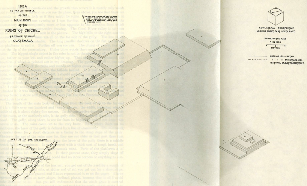
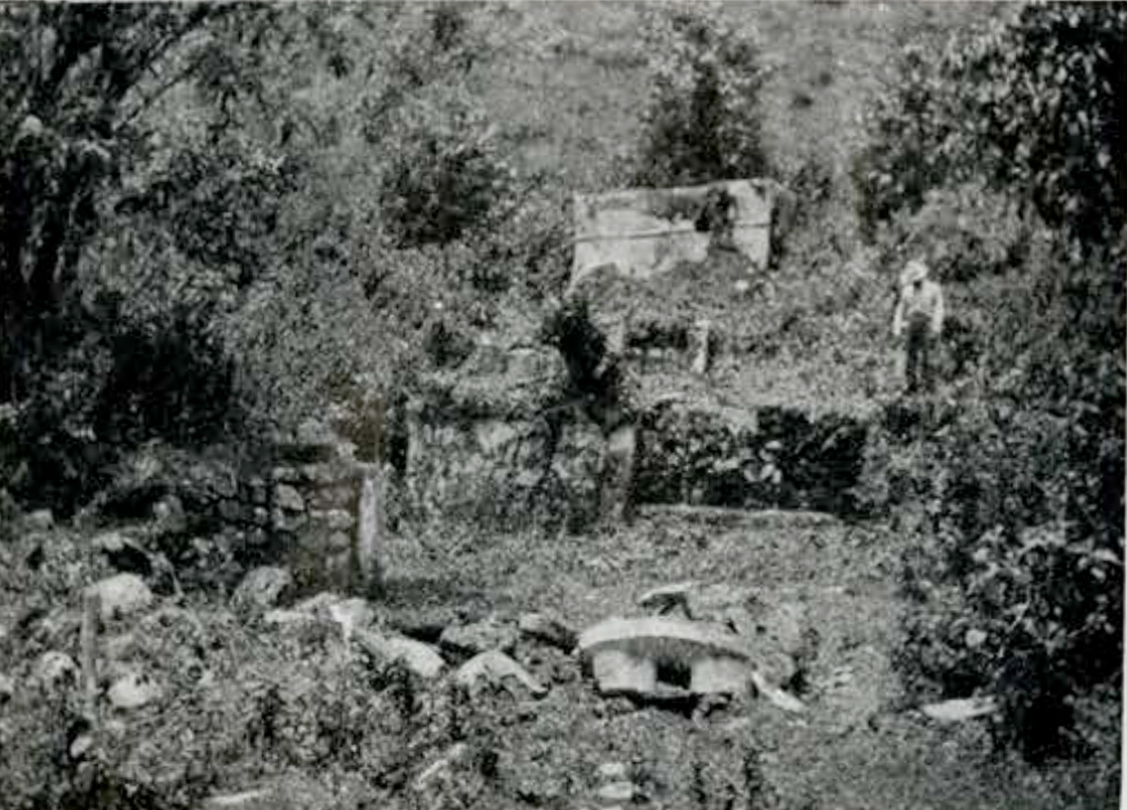
The ruins are about a league or a league and a half from Las Galeras. There is no riding road to the ruins from anywhere, but there is a footpath from Las Galeras to Chajul and that path goes close to the ruins. That was the way I took to get to them. I established myself in Las Galeras, not in the general’s sheds but in a little white-washed house close by, that happened to be empty, and engaged a halfbreed on the place to show me the way to Chichel. The ruins of Chichel are about fifteen hundred and fifty metres above the sea. You will see by my sketch [Plate XXIX1 that the ruins are situated on a shelf or table of land overlooking the Cusal River valley. On the side away from the valley, the shelf is partly split off from the ground about it by a gully with a small stream at the bottom. The shell is made a peninsula or promontory on the side of the valley. It is a flat-topped promontory with steep sides. The sides are wooded, but the flat top has long been a favourite place for cornfields and the growth that covers it is mostly only weeds and young brush. As soon as you see the place, from above, you see that there are mounds on it which look as if they might be ruins. You can see that much in Figure 8. I took it one evening as I was leaving. It is looking west over the promontory and consequently more or less opposite to the direction from which you are looking in my perspective drawing. The Cusal River valley is on your left in this picture but not seen in the picture. The high hills on the right and the wooded country under them are all on the fax side of the gully. The line of the gully is hardly distinguishable. The long parallel shadows on the flat are mainly the platforms ix and x. Further off you see xiii. The clump of woods, beyond, is at the tip of the promontory. Under those woods there are some small outlying ruins. The biggest single object in the ruins is not in the picture at all, but behind you, rather to your left and rather higher up. That object is the pyramid, the direction of which is pointed out in my drawing. The pyramid is off to one side from the main body of the ruins and stands on higher ground. It is about at the junction of the promontory with the hillside behind. If it had not been for my guide, who had once lived at Chichel, I should probably never have suspected the existence of that pyramid. The pyramid, unlike the other ruins, is covered with a tangle of bush and looks like any other small hill. I could not measure the pyramid; I could not even get a decent sight of it. But I estimated that, on the side I climbed it, it was about ten metres high. We chopped our way to the top, and on top found a stone and mortar idol, very like the San Francisco idol but about two-thirds the size.
The length of the main body of the ruins from the back of xii to the far end of i is a little over one hundred and twenty metres; the width, including what is visible of xi, is about eighty-five metres. In the perspective drawing, the near side of the ruins, or the northerly side, is the gully side. The brow of the gully is indicated. The gully, along there, is not far from its beginning and is not deep—ten metres or so. The ruins come out to the very brow. Even where there are no platforms, the brow of the gully is defined by a line of stonework. The stonework is carried down for a short distance as a facing to the steep slope of the gully. Whatever the age of the ruins may be, they are not older in that part than that little gully. You will notice that along the brow of the gully there is a middle stretch left indeterminate. It was covered with a thick mat of tough brush and I could not make out just how the stonework went. Parts of the platforms x, xi and xii are also left indeterminate. In their present state, they simply slope off into the surrounding ground and I could find no stone corners or anything to conjecture how the things ended.
On the right hand side of the box viii, you get out of the yard by a couple of stairs. On the left hand side, at either end of vii, you get out by a short slope. That is how it is on the ground and I have represented it so on the paper. I have represented the slopes as mere slopes, inclined planes, because that is all I could make them out to be. But you will understand that the whole place is covered with sod and has been tilled over and over and trodden by cattle, and it might very well be that those slopes were the remains of stairs and should have been so represented. That passage between vii and ix is a place I shall not forget in a hurry. I can say that it took me a day to measure the width of it. I was at Las Galeras one morning running over my notes of Chichel. I supposed I was done with the place and I was about to start away. They were saddling the beasts. All of a sudden, I gave the order to stop and take off the saddles; I had just found that I had not written down that measurement. I might have worked it out somehow, by additions and subtractions, but I wanted to satisfy myself about that particular passage and that took another day.
The thing marked v is simply a slab of stone standing on edge. The stone is not dressed but the edges and sides are about parallel. There is not much doubt in my mind but that the stone has fallen down, that originally it stood on end, and that it stood on top of the round pedestal stone in vi. But the case is like that of the inclined planes. I have represented the actual state of things though it may be misrepresenting the idea of the ruins. Even if I ventured to set up the stone, on paper, I could not conjecture in what direction it faced. I might add something of the same sort about two blocks on top of the compound platform xii. The front block, the big one, has some traces of having perhaps had a smaller block on top of it—some superstructure. And the back block was a pedestal for something; you can trace the base of a plaster image on it—marked viii, which seems to have been the place of some plaster idol affair. It is choked up with plaster rubbish and I could not exactly see what the box was shaped like on the inside. The inside drawing is merely representative. And on the outside there are ornaments and details not shown; in particular, some narrow horizontal mouldings or ledges running round. And my guide told me a curious thing. On a certain ledge or shelf at the back of the box, that is to say facing iv, there used to be a row of smooth balls of plaster or mortar. And they were attached with mortar to the shelf where they stood. The balls were bigger than a man’s head and they had something the shape of a man’s bead. When my guide lived at the ruins and had a cornfield on them, he had often noticed those round ornaments, as he considered them, and one day he had the curiosity to break one of them off from the shelf. And he was surprised to find that the thing was not nearly so weighty as it looked. Evidently it was hollow. And with some trouble, he broke it open with his cutlass and found, inside, a human skull. The skull was encased in a thick layer of mortar. And so it was with all the other balls. That was a number of years ago. There are now no remnants of those ornaments to be found.
Chichel is not a hamlet; it is simply the place of the ruins. The land it is on belongs to a native, a captain in the army and employed on the President’s staff in Guatemala. The land is looked after by the man’s brother. The brother, however, does not, or at least did not, actually live at Chichel, but in the neighbouring village of Chajul. I thought I might as well go and look at him. It was not far—a couple of leagues from Las Galeras to Cusal and a couple more to Chajul. It is more or less up hill all the way. Las Galeras is about fourteen hundred metres above the sea; Cusal, a village about the size of Uspantán, eighteen hundred metres; and Chajul, about two thousand. Chajul is a cold, wet place. It is on the south side of a range of wooded hills. If it is not raining, there is a wide view to the south, the basin of country that Chajul and Cusal are both in; and beyond that, a high mountain ridge, the mountain between Cusal and Cunén. But it is mostly raining or misting. As for the village, it is a mud hole on the side of a hill. It is amusing when you are in one of these places, Chajul or Uspantán or Tactic, to look at the map and see these poor pelting villages put down as important cities. All the signs of life are a knob of drunken Indians somewhere, an occasional draggle-tailed woman with a water jar on her head, pigs and goats going about to keep the weeds down. And yet it happens that this out-of-the-way village of Indians is able to attract travellers in great numbers and from distant places. The dingey dilapidated looking church is a noted shrine, a Guatemalan Sainte Anne de Beaupré. Many miracles are attested. The great day is the second Friday in Lent. Pilgrims are there from as far as Mexico and Salvador. The hovels of the inhabitants are full of strangers. Crowds are camped in the open places under tents and booths. The mud hole has one moment of strange importance. But it is only a moment. There were no crowds the evening I got in from Las Galeras, nothing but silence and rain. I cast anchor in an empty out-building of the church. There was not even a resident priest. I had difficulty in getting supper. My attendant reported, “No supper anywhere.” I had to go prospecting myself and finally got supper; but it cost me a dog bite. I was at the door of a house talking—or rather listening—to a woman telling me the usual tale; she was sorry; impossible to get me anything at that hour; come in the morning; and so on; and at that point a dog rushed out of the house barking and got a nip at me before I could turn, and then rushed back to where she came from—a savage bitch that had evidently just had pups. But the interruption somehow changed the lady’s thoughts. From that moment, I began to be an interesting person to her and she ended by giving me supper and everything else.
Well, the point is, I saw the Chichel man. He turned out to be the clerk of the courthouse in Chajul and, for the time being, a very influential person. The alcalde, or mayor, being an Indian, not able to read or write, and speaking very little Spanish, and drunk after ten o’clock in the morning, he has to go very much by what the clerk tells him. The clerk is the grand vizier, a man of about thirty. He gave me to understand he was not making much out of his job and had thoughts of throwing it up and going to live at Chichel.
I should mention before I finish with this region that there is some antiquarian work to be done at Las Galeras. Not long ago a quantity of interesting pottery was found there. I had great hopes of getting it, but I found the owner of the place had gone and taken the pottery with him, and furthermore, that he was no longer the owner. He had just sold out to the present owners. The pottery that was found had been in one small mound that was pointed out to me. It is on the top of the promontory as I have called it, a few steps from the house I lodged in.
The direct way to Nebaj is by Cunén. You go through Cunén and branch off to the right, as the diagram shows. You get over the Cuchumatán top through a gap. Cunén to Nebaj is about five leagues.
Nebaj is about the same height above the sea as Chajul but not nearly so rainy, and the situation is more inviting, a fine tract of rolling country sheltered by mountains. The village of Nebaj is the most important place there is between San Cristobal and Huehuetenango, and it is the only place north of the Cuchumatán line, in those parts, that has [1913] a telegraph wire. Years ago, when I first visited Nebaj, it was a different place from now. There were very few natives in sight and they were evidently in some awe of the Indians. The massacre of Solomá was still in people’s minds. A foreigner was a rare visitor. There was an Italian priest who took me in and roasted a fowl for me with his own hands. For forage and guides and so on, I had an order in my pocket from the governor, in case there was anybody who could read it. The priest was a Neapolitan and I remember he remarked it was a long way from Naples to Nebaj. But Nebaj today is quite a civilized place: whitewashed houses, natives with collars and neckties, the alcalde no longer an Indian, a telegraph station, a shop that sells penknives as well as hoes and cutlasses, and above all, an unceasing coming and going of labour contractors and plantation agents getting out gangs of Indians for the Pacific coast. And there is rum. The place stinks of it. The Indians are drunk from morning till night. There is a distillery in Nebaj. The black sugar, that comes up from San Francisco and other places where sugar cane grows, is melted back into syrup in Nebaj and distilled into rum. But that rum is not enough. Rum has to be brought in from other places. An Indian in the woods, or on his land, is not a drunkard. He could not be. If he had any rum, he would drink it up at once and be done with it. But in town he has no chance. In the days I was in Nebaj you could hardly see an Indian on the street after nine o’clock in the morning who was not already dizzy. I used to think that Chichicastenango was the drunkenest town in the country, but now I think it is Nebaj. My plans at Nebaj were upset by rum. There are two ruin places that I know of that are to be got at from Nebaj and I did nothing at either of them, and one of them I never even saw. The Indians I was going to take were never sober.
The ruins that I saw may be called the ruins of Nebaj. They are on the southwest side of the town at about ten minutes’ ride. They occupy a small table-ground. They seem to consist mainly of a group of platforms: long, high mounds with flat tops and sloping sides. Those ruins do not resemble any that I have so far described. What they resemble is a group of ruins in Xolchun, the group of platforms that I have numbered xxxiv to xxxix [Plate XXX]. The Nebaj platforms, like those of Xolchtm, were covered with sod, but in Nebaj there was no stone peeping out from the sod, no signs of stairs up the sides of the platforms, and, whether the modern inhabitants have robbed the ruins of stone or whatever may be the reason, there were no walls or masonry visible anywhere in the ruins, nothing but those big green platforms. At a little distance from the platforms, however, there was at least one mound of another sort. It was a small round mound, four or five metres across, made of earth. It was dug into some years ago by a couple of treasure hunters. They dug a deep pit in it. They found no gold or silver, but they found some pottery1 which is now, I believe, in Guatemala City. This is a round, hollow, smoke-blackened object, apparently the lid, or detachable top of something. It represents, coarsely, the head of probably a cat-beast, with outstanding eyes, and with the mouth wide open. There is a wide opening in the bottom, or throat. The thing sat on its rim or collar. Evidently smoke, or fire, was meant to rise from some vessel underneath, and pass through the open throat, and come out of the mouth. It stands nine and one-half centimetres high, with a bottom diameter of eleven centimetres. I found one object which was the result of some subsequent poking in the same pit. There was nothing valuable found then.
The ruins that I did not see were some stone ruins at a place called Xolkil, or rather Big Xolkil. There is a big and a little Xolkil. Big Xolkil is a hamlet northwest of Nebaj, five or six leagues off. There are lofty precipitous mountains in that direction and Big Xolkil is at the foot of them, on the Nebaj side. The alcalde of Nebaj very obligingly placed three or four Indians at my disposition to go with me to the place as guides and choppers and baggage carriers. There is no riding road to the place. But I never got there. I never started. I made my preparations over night but in the morning the Indians did not turn up. The alcalde sent out to find what the matter was and, after some hours, it appeared that the men had got too drunk the afternoon before to get ready for the trip and were still in no state to get ready. The alcalde thought the best thing then was to appoint other men for the next morning, and they were notified. But the morning came and not the men. By and by, one man did come, but too late to start; and all his preparations for the trip appeared to consist of half a bottle of rum. He was slammed into jail; and so were the others, one by one. Before evening the alcalde had them all in jail. But that did me no good. I thanked the alcalde and told him I had decided to go on to Xolchún. I would come back to Nebaj at some more favourable time. Probably I had struck the place at an especially bad moment. The plantation agents were at the height of their activity, scattering money, advance pay for work, and every Indian was able to buy rum. The rum business and the coffee business work together in this country, automatically. The plantation advances money to the Indian and the rum seller takes it away from him and the Indian has to go to work again. Work leads to rum, and rum leads to work. It does not matter that the work happens to be plantation work. It might as well be excavating ruins. But to get results from the system, the rum and the work have to be in different places. That is the moral I drew from my experience at Nebaj.
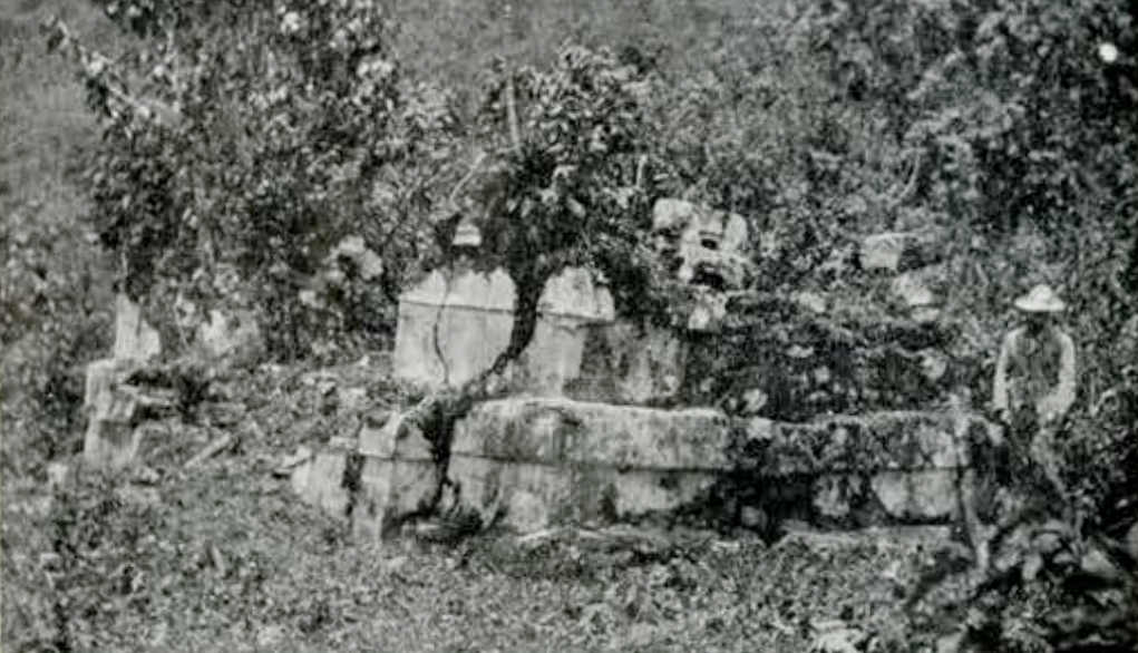
Nebaj to Xolchún is southwest. It is about seven leagues, up one side of the mountain and down the other. The gap where you cross the top is not the highest point of the road, it would seem. According to my barometer, the highest point of the road, about twenty-five hundred metres, is at a point that you climb to on the southern face of the mountain, before going down hill for good. The lowest point is about sixteen hundred metres, at a point between the Rio Blanco—so called because it is a foaming torrent—and the San Juan. From Cunén to Xolchún, on the direct road, there is no such great up and down; there is no mountain to cross; the distance may be about ten leagues. Xolchún is so far west, however, that for anybody coming down from abroad to look at it, the shortest way would be to take the railway from Puerto Barrios to Guatemala and thence to San Felipe, too many goats and sheep. Wherever there are no standing crops, goats and sheep are let about and very little bush can make head against them. There are nettle trees and prickly pears on the ruins, and here and there, there may be a formidable thicket of them. But on the whole, the ruins are clear of bush. They are hidden only by the sod; you can see the artificial nature of them as far off, almost, as you can see them at all.
The general appearance of the place, as I saw it, you can judge from Figure 8. In the centre are the united rivers, the Cuchumatáns on the left and Pueblo Viejo hill on the right; you can just see the water about at the confluence of the rivers, and the greater part of the ruins is in front of you. The picture is taken from the top of the two story platform xxxi. The sweep of the whole picture is from a little left of xxiii to a little right of xxxvii. You see the mounds with the tufts of bush on them. The big mound on the left is of course number iii. And you see the fields of stubble all about. The yard xxv is itself a stubble field, the bush in the middle of it being xxvii.
The ruins of Xolchún, as you will find on my plan [Plate xxx], measure about three hundred and twenty-five metres north and south, and about four hundred and twenty-five metres east and west. I have forgotten the measurements of the ruins of Copán, but within the limits of Guatemala at least, it is probable the ruins of Xolchún are much the most extensive that exist. It is a long time since I have seen the ruins of Quiché, but I think you will find they occupy much less ground than the ruins of Xolchún, while, as for the amount of building work in the two places, there is more work at Xolchún in the single pyramid number iii than in all the ruins of Quiché together.
It was a long business measuring Xolchún, even in the rough way that I measured. When I set out on this trip, I had no idea of actually measuring ruins at all, much less of constructing plans and perspectives. I had the idea of ruins in my head but no precise notion of what shape my report might take. My notion was that the camera would convey all the visual ideas necessary and that if anything should seem to be wanting, here and there, it could be supplied by talk. I got rid of that notion at the first ruins I tried to photograph. If any ruins had been reasonably clean and in addition there had been a good point to view them from, something might have been done with a camera. But as it was, it was plain that I might photograph the ruins from every point of the compass and talk about them for a year, and as far as the main thing was concerned—the system of the ruins—you would have no more notion at the end, practically, than you had at the beginning. There was nothing for it but measuring and drawing. So I measured and drew. But with a pocket tape for all my surveying instruments, the measurement of so big a place as Xolchún was tedious, especially with raw Indians. I had two or three Indians daily from Aguacatán. I gave them some multiple of a metre to measure with, and they had to learn how to measure. At the end of each length they stuck a cutlass in the ground and they had to learn to stick it at the end and not somewhere within a hand’s breadth. And they had to count. When they stuck the cutlass in they had to sing out. I was usually some distance ahead. And they would continually skip numbers; they would sing out “Four, five, seven,” or “Eleven, fourteen, fifteen.” It bothered them to count in Spanish. They would say things like “Twenty-eight, twenty-nine, twenty-ten,” and then get confused. Afterwards I had them sing out in their own language and the counting improved. They learned, presently, that a distance had to come out the same backwards as forwards. And I believe their errors in the end hardly amounted to one part in one thousand. The tendency, I think, was to diminish distances. It is probable the true scale of my plan is not actually 1 in 1000, but something like 1 in 1001.
Besides the great extent and number of the ruins, there is another peculiarity about them, especially troublesome to a man without a theodolite. The layout of the ruins is not rectangular; at least you cannot depend on its being rectangular. The lines of viii, for instance, do not turn out parallel, or at right angles, to those of xxxviii, or again to those of xi or x, and so on. In any of the other ruins I measured, you could assume that all the plan lines were either parallel or at right angles to each other. And besides, there is a great deal of symmetry of arrangement to help you. In Xolchún, it is probable that most of the mounds are in themselves rectangles, but in the arrangement of them, there is neither rectangularity nor symmetry to any useful extent. The absence of symmetry, the absence of any simple arrangement, is plain enough to anybody who looks at my plan. But it is not so plain on the ground. I wasted several days, I suppose, tramping up and down, looking for lines of arrangement, simple lines, which I supposed must exist, if I could only see them. My Indians followed me about with armfuls of range poles. If three or four things looked as if they might be in line, I tested them with range poles. But it always turned out the things were not in line, or if the centres were pretty nearly in a line, that line would not be parallel to the side lines, or something of the sort. I used up a great many range poles. I had the mounds looking like hedgehogs, almost, before I was done; but without finding any arrangement such as I was looking for.
It is evident, of course, that there is arrangement. The mounds and things are not thrown about, higgledy-piggledy. For one thing, there are evident groups. And if the mounds, and lines, are not exactly parallel or at right angles to each other, throughout, yet they are usually pretty nearly so, nearly enough to deceive any casual spectator. And the very aberrations, often, suggest intention. But whatever the intentions and arrangements may be, they are not clear enough to be any help in measurement. It is they themselves that have to be discovered by measurement. I have not discovered them. The discovery of them would need exact measurements and I could not take exact measurements; not really for want of a theodolite, however, but because the ruins are covered with sod. There are almost no sharp lines to measure to. Underneath the sod there is stone, stone stairs usually, running all the way round and all the way up, so that the building is more or less like a truncated pyramid, oblong or square, but narrowing in to the top. These stairs would make a great many stone lines to go by, if you could see them. But the stairs are filled with rubbish and covered with sod. The stone work peeps out here and there, but usually more or less ruinous or dislocated and almost never enough of it to establish a line. All you have are things of that shape that you see represented, predominatingly, on my plan. I do not, in the main, pretend to represent stone lines. All that I attempt to represent or locate, as a rule, is the mound, the visible envelope, in which the stone ruin is embedded.
I measured the length and breadth of the mounds, both bottom and top; that is, as near as I could judge the limits, bottom and top. And I took great pains about the direction of the mounds. If there was a fair stone line, I took the direction from that. If there was no acceptable stone line, then I usually took the base line of the mound, if the base line was anything definable; otherwise, the top side-lines, or an average middle line. But trying to be exact about the mounds, as they are, is bound to be more or less lost work. No two people, probably, would agree about the lines or even the visible mound; and if they did agree, they could still never be sure how near the visible surface tallied, or did not tally, with the stone underneath. If you cleaned the mounds enough to survey the stone, and corrected my plan of the ruins accordingly, my opinion is that the position of centres would not be seriously altered, but the mounds would in many cases be rotated. The rotations would be slight. But in tracing the recondite arrangements of Xolchún, those slight rotations would probably be important. My plan is what I say it is: approximate. It could not be anything else. And I hesitated greatly about measuring Xolchún, but it happened that besides the ruins being practically clear of bush, it was a moment when there were almost no standing crops on the place. A more favourable moment might never come; and considering the importance of the ruins, I thought the Museum would be glad of even an approximate plan. In my numbering of the ruins, I do not intend to indicate any theory of grouping them. The numbering winds about, merely in what seemed to me to be as easy a way as any for the eye to pick up the numbers.
The southern part of xv is left indeterminate because the mound there is in a state of great ruin or incompletion and merges indeterminately into the adjacent ground. So again with the southern part of i, and the eastern part of xxxi. The top of ii is not in the middle, because the ground is higher on one side than on the other as you see in the profile. So again with xxix and xxxviii. xxxviii is a mound that has acted as a dam, the ground filling up on the south side. The crooked west base line of xix is partly due to ruin but mainly to a wave in the ground. In the top platform of xix, the south side, in most of its height, is a visible wall indicated on the plan by a black line. So also there are visible walls on the south sides of v and vi, on three sides of xxxi, and to some extend on three sides of the yard xxv; and in xix, again, there is some wall visible on the east side under the brow of the lower platform. On most of the walls visible there is a good deal of plaster preserved. The north side of xxi is shown as a waving black line. It is not a wall, but neither is it a slope. The mound is torn down, or ruined, more or less vertically. So again, the west sides of viii and xii and the north end of xxiii.
You can say, I suppose, that the ruins of Xolchún were never measured till they were measured by me. But I was not the first investigator of them. There have been at least two investigators of a certain sort, before me; and they have done some damage. My information about them I got mostly at the ruins themselves from a farmer in whose house I lodged. He is the owner of part of the place and he has been living there for some thirty years. He is now a man of fifty-five or sixty.
The first investigator he tells about was a certain Colonel Elgueta, Manuel Garda Elgueta, who lived in Totonicapán. He died just a few years ago. He was a man of antiquarian tastes, but (I should say) without much knowledge. Like most of these people, he had no taste for exactness. He wrote some pamphlets, about Indians, that I have seen—full of absurdities. This man came, it seems, at two different times to the ruins of Xolchún and dug at them. The first time was in the later eighties of the last century, or in the early nineties. He made a great many finds (I do not know what exactly) and some of them, at least, were exhibited at Chicago in 1893, and were reported to be worth a great deal of money. What the fate of the exhibit was I do not know, but I have an impression that some of the things found their way to California and others to Paris. You could probably find out.2
Elgueta’s second digging was some time about the end of the century; and again he got a great many things. My landlord saw the things, but his account of them was never very intelligible. There were some things made of steel, according to him; but he went on to describe the metal as of a whitish yellow colour. And there was some little machine for boring holes in stone; you gave two or three turns to something and in a jiffy there was a hole started in the stone. In these last diggings of Elgueta’s there was a partnership between him and my landlord. My landlord was the owner of the site, and I think, gave Elgueta the necessary men, and Elgueta managed the work. Elgueta and my landlord were to go halves on the finds, or on the proceeds of the finds; Elgueta was to sell them somewhere. The work at XoIchún was getting on famously when of a sudden, Elgueta bad to take to his heels. The law was put in motion against him. An armed commission arrived one night with orders to seize him and bind him and take him to Huehuetenango. Somehow or other, Elgueta got a few moments’ warning of the commission and managed to get away. He remained in hiding, I believe, for a long time; and he never came back to Xolchún. As for the finds that had been made that were going to be the fortune of the partners, Elgueta had always kept sending them off to Totonicapán, my landlord believes it was; and that was the last my landlord ever knew of them. He regards himself as having been swindled by the colonel.
The spots where Elgueta worked are indicated on my plan. I do not know the order of them, exactly, but it was he that demolished the eastern side of xxxi. He made the excavation round iv, v and vi. These are flat-topped masses of masonry. It looks as if iv and v, at least, were originally one mass, and Elgueta had demolished the middle of it. He also made the hole between that place and vii. Almost his last job was to tear down the west side of vii. He had just begun to tear down the east side of iii when his operations were put to a stop. All the damage he did to iii is where you see a piece of black line at the inside of the long platform.
About half a dozen years after the flight of Elgueta, the second investigator appears: a man called Garcia, a Mexican, I believe. He is now living in Huehue-tenango and I have spoken to him. He confirms what my landlord had to say. Garcia is a man who has been a miner, and a cattle dealer, and a publican, and I don’t know what else. He has no pretensions to being an antiquary. But he had heard of things being dug up at Xolchún and he thought he might find things too and get some splendid price for them. It was a mining enterprise. He got permission from the governor, somehow, to go and dig. He found absolutely nothing. The only place of his that I have troubled to mark is where he broke through the middle of xxiv. Besides that, he dug a little hole in xxx at the middle of the north side. There are remains there that indicate a plaster image or something of that sort. He also thought corners might be worth trying; he sank holes into the two south corners of iii. Garcia, like most people of the country, regarded archaeology as a branch of mining; and I suppose it is, to some extent. But it was a branch of the business that was new to Garcia. He formed an unfavourable opinion of it and soon went away.
I am not sure, but I think it was at the time of Elgueta’s first diggings and at Elgueta’s instance, that the affair marked xxvii was destroyed. What is left of the affair now is a pit half filled with loose stone and a ruined border round the pit. What it contained formerly was a great square cistern, or rather cubical cistern, cut out of one stone. It was dislodged with great labour and dragged on a sledge, little by little, to Aguacatán. It took seven yoke of oxen to drag it, on a level road. The cistern was placed, and now stands, in the middle of the little village square. The cistern, on the outside, is about one and a half metres long, one and one-tenth wide and one and one-tenth high; and the sides are about twenty centimetres thick. It is flat-bottomed and on one side, near a corner, there is a vent or bunghole, flush with the inside bottom. And that struck me as very strange, because Indians who know the cistern of old and helped to dislodge it, declare, with one voice, that it was sunk in the ground almost to the brim.
There seem to be some other sunken cisterns on the place; xvi, xvii and xi are squares of visible stone. You will see by the table of heights that they rise very little above the ground. And they are probably all hollow, like square wells. In xvi and xi, the mouths and top surfaces are hidden under loose stone, piled up high on them by the modern tillers of the soil. But xvii is not covered; it is only choked with loose stone. The mouth is visible; you can measure the thickness of the four sides. They are about thirty centimetres thick. Possibly xi is a single stone like the cistern taken from xxvii. The other two are of built masonry.
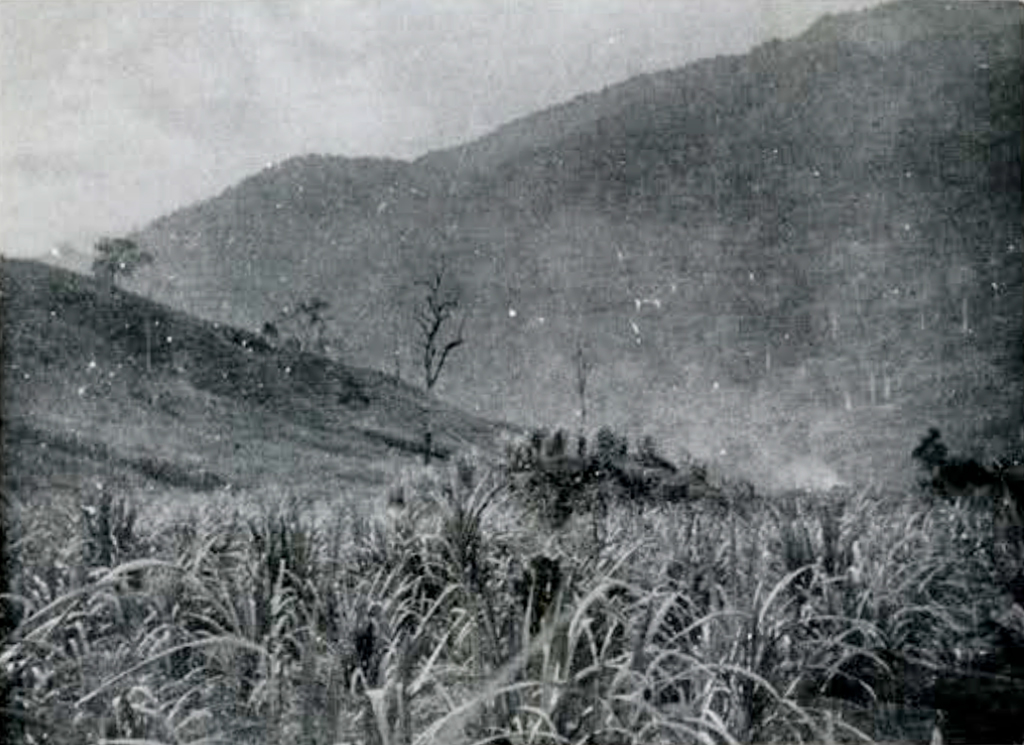
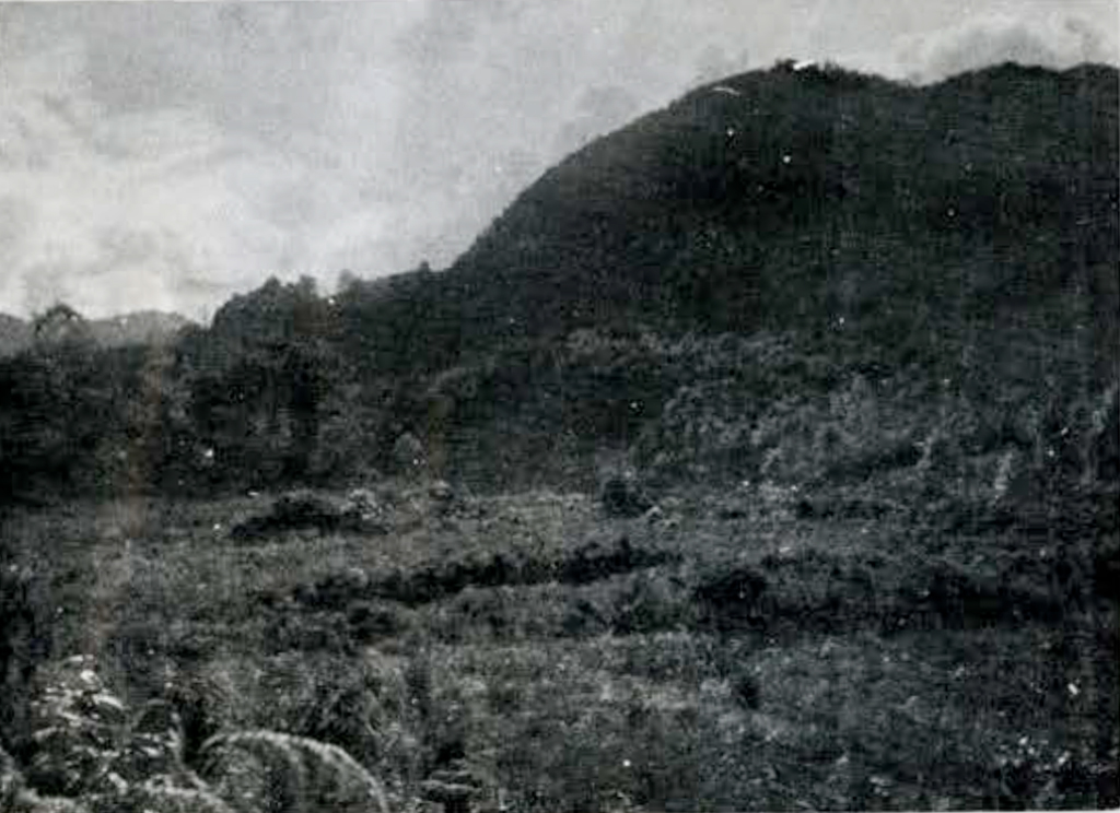
On the top of the pyramid iii there is a hole, also on top of vii; and through the top of vii there is a trench. The holes are more or less rectangular. The sides are more or less vertical; but they are rough as if they were the work of some excavator. There is no doubt that the trench is an excavation. I could not learn the history of any of the three. None of them was made by Garcia, because I asked him. My Xolchún landlord, who lives on the spot—his house is just south of viii—says that the hole on top of iii has been there forever; that is, since anybody remembers. As for the hole in vii, he did not know of its existence. He had possibly never been to the top. The mound is very steep and stony and a place of snakes.
In the middle of the east side of iii, down at the bottom, you see a hole or passage indicated. It goes down hill into the mound and goes under the platform, like a cellar, as you can see in the profile. To look at it, you would take that rough hole, or cellar, to be somebody’s excavation, but my landlord says it is not. According to him it belongs to the original structure and only looks now like an excavation because there was a falling in, some years ago, of the original roof and sides. He says the passage used to lead down to a well of water, a square stone well, or cistern (or bath as he himself sometimes called it) of beautiful, clear water. Where the water came from, he did not know. But there it was. And he supposes it is there yet, buried under the stone that caved in. When I think of that stone well with its constant supply of water, I cannot help thinking of the cistern torn out of xxvii, with the bunghole at the bottom. And I can hardly doubt that if you cleaned out xvi, xvii and xi, you would find bungholes at the bottom of them too. There must be channels leading to those bungholes. I won’t go on speculating.
It was shortly after Elgueta’s first descent on Xolchún, I believe, that the cave-in at iii took place. According to the Indians, the mound fell in and buried things because it was angered at Elgueta’s doings. The Indians have a belief that the cellar is inhabited by a mysterious snake, and they respect its habitation. The entrance was choked with bush and I had to take a cutlass and go in myself before the men would follow me. There was no snake. Inania arcana.
There are three pyramids—so to call them—on the place, iii, vii and xi. So shapeless is xi with rubbish and sod, that you can hardly see which way it faces, or where the corners are, or even whether it has faces or corners. You might almost think it was meant rather for a cone with a round base. On the north side of the base, however, at the west end, there is a little bit of stonework visible and it shows what must have been a straight line. That stonework is a bit of stair and, except for that bit, I should not have known there were stairs at or on xi. I did not notice any signs of stairs on vii. But the stairs on iii are quite traceable in many places, especially on the west side. I could not exactly measure them, but they would be about a metre high. I tried to use the pieces of stair visible, to get the direction of iii, but had to give it up. All the sides of the mound have bulged and the stair lines have bulged too. Within certain limits, you could get any direction you pleased from the stairs. That pyramid is the great feature of the place, to the casual eye. Roughly speaking, it is over fifteen metres high and about fifty-one metres square. And that pyramid is an object of veneration to the modern Indians. Not to mention the snake in the cellar, the Indians are continually going on top to burn incense. They do it for luck. And the doctors and wizards recite their gibberish up there, and take their patients up with them, or the relatives of their patients, and whip them up there on top, and so on. At the same time, the nature of their belief about the pyramid does not hinder the Indians from pasturing their sheep over it with perfect indifference. When you stand in the cellar of iii and look around, you see that the pyramid is not a heap of earth, inside, but a heap of stone. The stones are not very big stones, bigger than a man’s head though, usually thrown together anyhow, and, at least in that part of the structure, they are a compact mass. There may be some little earth in the chinks between stones, but very little; what you see is an almost pure mass of stone. On the other hand, iii, judging from Elgueta’s demolition, seems to have a good deal of earth in it, both top and bottom. Stone, with earth between the stones, is also what you see in looking at the demolished parts of xxiii, xxiv and xxxi, and in other places. But iv, v and vi are solid masonry: stone and mortar.
There is a curious thing about the inside of xxiv. When you look at the sides of the breach that Garcia made in it, you can see that at some distance below the present platform there was an older platform with a plaster floor. The present building is an improvement or heightening of an older one. It is evident that Xolchun is the work of different generations of men.
There are various ruins in the neighbourhood of Xolchún. Some of those ruins, if they were not near Xolchún, would themselves, I suppose, rank as important ruins. There are ruins on the Chalchitán heights. Those heights are more or less flat on top, forming a long table. It is practically bare of bush. And on that bare table there are various ruins strung out, covered with grass and sod. The most considerable of them is a direction northwesterly from Aguacatán and has a strong resemblance to the San Francisco ruins shown in Plate XXVIII. On the Pueblo Viejo heights, which are also a sort of bare flat table, there are also ruins —ruins of a peculiar kind. The principal objects are a number of square mounds, or squarish, rounded mounds. They might be about four metres square on the average and about four metres high, with a surface of stone and rubbish. They are stuck about, without any apparent order, and my notion is that they are graves, that they might have the same relation, perhaps, to the ruins of Xolchún as the group of blocks in Chipal, that I spoke of, may have to the ruins of the drawing. There are also ruins at Pichikíl, about two or three leagues off the road to Cunén, and at Lagunas on a mountain shelf on the way to Nebaj.
I have now run over the various ruins with you that I was going to speak of, and told you nearly all that I had to tell. I suppose that what will have made the clearest impression on your mind will have been the drawings. You will understand, though, that the drawings are not meant to show details. Details, as far as possible, are ignored. Compare for instance, in the Chipal ruins, the drawing of box vii with the photograph (Figure 3) showing the ornaments I spoke of, Garcia’s embattlements and loopholes, ignored in Plate XXVII. And details that are not ignored may be merely representative. In flights of stairs, for instance, in their present state it is often impossible exactly to count the stairs, much less get their several heights and treads. Take the stairs in Chipal, going up from the yard just in front of xiv. In my drawing you would find, if you took the trouble to examine, that I have drawn in five stairs on each side of the pier; but you see in the first Chipal photograph, as I said when I introduced it, that the stairs are blocked up with modern stone fencing. I do not know how many stairs there are, and do not know any of their measurements, except their length. The thing is that there are, or were, stairs there. I thought it was important to represent stairs. And I have represented them. But I do not mean you to count them. I have put you on your guard in such cases by using dotted lines.
Those poor drawings of mine, situated as I was, cost me indescribable trouble. First of all, I had to put my notes together. My original notes of each ruin were on various scraps of paper, all dirty and rain-soaked. I put the notes together on one intelligible ground plan. Then on another paper I plotted the plan, or the corresponding perspective, to the scale I wanted. Then I pricked that through and finally inked it on the white paper I send you. By a miracle I was able to get some white paper in Huehuetenango. I always have a metric rule in my saddlebags. I manufactured a triangle, small but workable, out of a visiting card. But I never knew before what it was to work without a drawing board and a T-square. The drawings must have taken me, on the average, near a fortnight apiece. And now that I take them out of the hole that I worked in, and look at them in the sunshine, I see that the drawing leaves much to be desired. But it does not matter. The drawings succeed in telling you unmistakably, I think, what I meant them to tell and what photographs could not do.
In talking about the ruins, I have left the drawings, as much as possible, to talk for themselves. If I were to take it upon myself to talk for them, I should speak of some few points that happen to have struck me in comparing one ruin with another. They are points that anybody might notice.
First, as to bearings. There is no visible rule. The bearings of the ruins are various; and in Xolchún, there are several oscillations of bearing. You might say, however, that the bearings of Chipal, San Francisco, and Chichel agree roughly in being not far from northeast and northwest or the opposites, while the several bearings of Xolchún agree roughly in being not far from north and west, or the opposites. It happens too that the bearings of the Xoch ruins are about north and west.
Second, there is likely to be a pyramid building somewhere. In Xolchún, there is a group of pyramids. But in San Francisco there is none.
Third, in the Chipal ruins, consider the two platforms ix and x, you see that they are two parallel platforms on opposite sides of a passage and of equal length and height. And the sloping sides of those platforms, facing each other, are not stairs, but smooth masonry slopes as if to prevent anybody getting up. And you see the same thing over again in all the other ruins. The twin platforms of San Francisco are iv and v: in Chichel, ix and xi, and in Xolxhún xxiii and xxiv.
Fifth, at the foot of each of the twin platforms in Chipal and on the insider, that is to say on the passage side, you see an attached lower platform—might call it a sidewalk—running the whole length of the main platform. And you see the same sidewalk platforms in San Francisco and in Xolchún. In Chichel, I did not happen to find them, but the whole floor there is deeply disturbed by planting. You would probably find the sidewalks by continued searching.
Sixth, the passage, in every case, opens at each end on a yard. The two yards are joined by the passage; the passage is in fact part of the yards; the yards and the passage are all one floor. In the case of Xolchún, I am considering as one of the yards—though it is not much enclosed—the space south of xxii. In the Xoch, I have little or no doubt that the long sunken yard or floor that I spoke of would turn out, if cleared, to consist of what I have been calling the passage, with the yard at each end, and that the idol is on top of what answers to one of the twin platforms.
Seventh, one of the end yards is bigger than the other. In Chipal, for instance, the yard round xiv is bigger than that round viii.
Eighth, in San Francisco there is a complication. The bigger yard may be said to be divided in two. The main division of it, around ix, is separated from the passage by a small intermediate yard, about equal to the small yard at the other end. And there is a step up, as you see, as well as a barrier, between the intermediate yard and the main one.
Ninth, I should consider as homologous platforms, i of San Francisco, xi of Chichel, and xxii of Xolchún. The smaller of the two yards is closed—or commanded, as you might say in the case of Chichel—by a comparatively low platform opposite the end of the passage. Chipal is an exception, perhaps because the ground does not give room. As the drawing indicates, the ground falls away on one side, opposite the end of the passage.
Tenth, the larger of the two yards is a square, or very nearly a square. In Chipal, for this purpose, I do not consider the larger yard to include xii and xvi, but to stop at the end of its own floor. In San Francisco, I have to throw the two divisions into one and say that the sum of their widths does not differ very much from the length of the main division. In Xolchún the square is not rectangular.

Eleventh, the sides of the square are equal to the length of the passage. In San Francisco, I have to say that it is the sum of the widths of the two divisions that is equal to the length of the passage. And in Xolchún, the proposition does not hold. In Xolchún, you might say that the sides of the big yard were about equal to the length of the passage plus the width of the smaller yard.
Twelfth, in San Francisco, the length of the passage (or of the twin plat-forms) is equal to the extreme width across the platforms, from outside to outside. The platforms and the passage together form a square.
Thirteenth, I should regard as homologous buildings, xix of Chipal, xiii of San Francisco, and xx of Xolchún. The big yard is closed and commanded, at the side opposite the passage, by a two or three story platform, a compound platform, with stairs up from the yard.
Fourteenth, in Xolchún, for this purpose, I have to consider xxx and that part of xxvi that it stands on as together forming one compound platform. You will see what my notion is better in the profile than in the plan. There are no stairs represented either in plan or profile, but in front of xxx, where the side of the yard is only dotted in, I think that if the place were cleaned, stairs would be found going down to the yard. That place, as it is, is a slope of rubbish and ruin.
Fifteenth, as for Chichel, I should hesitate to regard iv as the homologue of the platforms I have been speaking of. It is true, iv is a compound platform, but there are no stairs. I should suppose, rather, that the homologue was viii, though not placed opposite the passage.
Sixteenth, the stairs in question are in two parallel flights. In Xolchún, the stairs are not visible, supposing them to exist.
Seventeenth, in San Francisco and Chichel, the stairs do not start up from the floor of the yard, but from the lower platform.
Eighteenth, in San Francisco, there are also back stairs; the back stairs are a single flight of the same width as the interval between the two front flights. Those back stairs only go down to the foot of the little platform.
Nineteenth, the centre of the big yard is occupied by a block or box of masonry —an altar, or a shrine, or whatever it may have been—some evidently important though comparatively small thing.
Twentieth, but what this particular thing is, varies from place to place. In Chipal the thing is a block. The box is somewhere else. In San Francisco the thing is also a block and there is no box anywhere. In Chichel the thing is a box and there is no block anywhere. In XoIchún the thing seems to have been neither a block nor a box. The only block in Xolchún is xli, unless you count iv, v and vi. An excessively low block is x. The central thing in the yard xxv of Xolchún, the thing that was in xxvii before it was gutted, was, as I have said, a cistern; at least, the cistern is all I hear about. You might think it worth noticing that, in Chipal, the block xiv has a number of satellites and that two of them, as I have said, the round ones, may have been cisterns or big basins.
Twenty-first, at Chichel xii, at Xolchún xix and xxxi, are more or less lonely compound platforms with a certain resemblance to each other. Chichel xii and Xolchún xxi have, in addition, a certain resemblance in situation with respect to what I have been calling the big yard. In xix of Xolchún, the front or easterly side of the lower platform is oblique to the other sides, somewhat as if it were meant to face mound xx.
Lastly, in all the ruins, you have to reckon with unexpected departures from symmetry, or regularity, even in details. In Chipal, if you look at the satellites of xiv, you will see that one of them, the one furthest to your right, is not in line with its companion on the other side. In San Francisco, in the compound platform xiii, one flight of the front stairs is wider than the other. In the same compound platform you can count at least five stories, if you wish; and you will find that the insets, by which a story is made shorter than the one below it, are not bound to be equal at the two ends. In Chichel, in the yard, you will see that the corner of x is not so simple as that of ix. And it is easy to see that the platform xi is not in the middle, opposite the end of the passage or of the yard. In Xolchún, both in xix and xxxi, the top platform is not in the middle of the bottom platform. The top of xxiii is wider than the top of xxiv, xxviii seems to be not a parallelogram, since the long sides converge a little toward the north. The long axis of xxxvii bisects xxxvi, apparently, but not xxxv. And so on.
So much for the drawings. Naturally, there are things to be seen at the ruins, and some of them very interesting subjects of comparison, on which the drawings are silent.
At all the ruins there are plentiful remains of plaster and mortar. And the remains make it evident that the buildings, originally, were completely plastered over. There is little or no dressed stone; facing stones may be brought roughly to shape, as you can see in the last picture. But for smoothing the surface, the builders depended on mortar. The mortar, at least the surface mortar, has now mostly disappeared. It is the ordinary effect of weather, no doubt, partly; but mere weather, I should say, was not the main cause. The mortar itself, I should say, was not good mortar, no good sand in it. And then the sustaining masonry is like all the Indian-ruin masonry I have ever seen; it is poor masonry; it cannot help settling and bulging and becoming deformed, and the plaster cracks off. But worst of all must have been the fires that have swept over the ruins, the annual fires that are a part of Indian agriculture. No mortar could stand those fires. The plaster and mortar images and similar things, of which there are evidences at every place from the Xoch on, are also nearly all destroyed. The only mortar images I saw that were in any sort of preservation were the two or three that I mentioned in connection with San Francisco and Chichel and two or three at the Xoch. You have plaster and mortar, as I say, instead of cut stone masonry, in these ruins; and you have plaster and mortar images instead of images of carved stone. I came across only two stone carvings. One of them is illustrated in Figure 1, the stone slab in the Xoch. The other was in Xolchún. It was equally crude carving and less interesting to look at. It happens, in the last photograph of Xolchún (Figure 4) you can see the stone in question. It is a black stone that you see standing on the ground, not in the middle of the picture, but rather to the right. It is a little less than a metre high; to be precise, ninety centimetres. It was lying in the rubbish there, and I set it up. What you can make out of the carving, if you look sharp, is down at the bottom. There are two eyes looking straight at you and a nose between. One of the eyes, unluckily, is obscured by a twig. The stone is cut across flat, both top and bottom. The face does not go below the nose. The stone was evidently one section of a sectional image. The carving is shallow, like that in the Xoch, hardly more than sketching on the stone, and the back of the stone is not worked.
These clumsy primitive carvings are in strange contrast with such things as the great cut stone cistern of Xolchún. They are also in strange contrast with things that show the intelligent geometry of the ruins and with things that show the level of taste that you see, for instance, in the pottery of Chipal. What can be the explanation? I do not know. But I have a notion that the key to it may be another strange thing that I noticed.
When I was cleaning the image in the Xoch to photograph it, I noticed there were little bits of plaster sticking on it. It struck me as very odd. Why should an image have been plastered over? Some accident perhaps. But you can fancy my astonishment, in looking over the Xolchún image, when I saw spots of plaster on that image too. You can make out some of the spots in the photograph, in the upper part of the face. I gave up the notion of an accident. Both of those primitive carvings had been plastered over. Why? Because they were primitive. In order to improve them. Old things were improved or renovated. The old platform under xxiv was improved by having a new one built over it. And the old idols were improved. The primitive stone idol became the core of a brand new plaster idol. The plaster has since crumbled away, leaving the old stone bare again. But why keep the old stone, even as a core? It is not like keeping the old platform to build on. The old stone was kept because it was sacred. You see in churches today how pious peasants, in spite of the Pope’s ordinance, persist in overlaying and, as they consider, beautifying sacred images with new and incongruous dressings. The proceeding of the Indians was something similar. The Indians of a later day were bent on improvement. The old stone looked ugly to them. At the same time, it was, so to speak, a god. They had no notion of throwing it away. What they did was to cover the ancient lineaments out of sight and, like modern liberals, bring the divinity up to the standard of the age. That is the theory I offer you about the plaster spots.
This is the longest letter I ever wrote. I hate writing. It makes me impatient. I want to speak. On the fifteenth of November when I sat down to write to you I actually thought that probably I could say nearly all I bad to say in the course of an afternoon. And so I could have done, if it had been a question of talking. But I find I have no facility at putting my ideas on paper. I suppose because I am not used to it, or because the ideas are of a new kind to me. This writing, that I thought I should do in an afternoon, or a day or two at the most, has actually taken me six weeks.
1 At Nebaj was found in 1904 one of the finest examples of ancient Maya pottery vessels. This has been reproduced in Plates XXIX and XXX of the Museum’s publication, Maya Pottery, Philadelphia, 1928. It was fully described by the late Eduard Seler under the title Ein Hieroglyphengefass von Nebaj en Guatemala in his Gesammelte Abbandlungen, III, 718-729, Berlin, 1908. The vase is now in the Fenton (formerly Fleischman) Collection, London.–J. A. M.↪
2 The Guatemalan archaeological collections exhibited at the Chicago World’s Columbian Exposi¬tion in 189$ were scattered. Some are in this Museum, some in Field Museum of Natural History, Chicago. Strange to say, in both museums, some of the material is accessioned as the “Gift of the Ecuador Commission.” This information of Mr. Burkitt’s may help to settle the provenance of some of the specimens in these collections, such as the beautiful pottery vase published in Plates XXVI and XXVII of our album “Maya Pottery,” which came from this source and for which the only provenance given is “Department of Huehuetenango.” It may well be one of the results of Elgueta’s work at Xolchún.-J.A. M.↪