Having given the principal facts in connection with the work accomplished at Burnet Cave, we shall now consider the second occurrence of associated “finds” to which we referred in the beginning of this report, namely that covered by archaeological and geological work done in the region of Clovis, New Mexico. The area covered by these investigations lies between Clovis and Portales near the boundary between Curry and Roosevelt Counties, New Mexico [PLATE XVII]. Here in Township 1 south and extending from Range 34 east to the edge of Range 36 east we concentrated our efforts. Between the towns of Clovis and Portales, a distance of about eighteen miles by the highway and running in a general east-southeast direction are a series of shallow dry basins, resembling old lake beds, which may be the remnants of a once larger drainage system. Udden21 points out that the Brazos River once headed in the eastern flanks of the New Mexico Mountains.
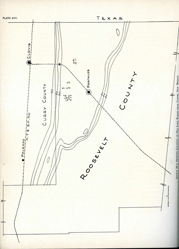
Image Number: 13143
This topography is quite different from that just described along the Guadalupe Mountains. Clovis stands on the “Llano Estacado” or “Staked Plains”—a flat region where only sand dunes, rising along the edges of shallow depressions, break the monotony of the landscape till one reaches close to the broken country, dipping down to the Pecos River. About seven miles south of Clovis on the highway to Portales one comes to sand dunes above a depression, which deepens somewhat as one proceeds towards Portales, and which locally is known as Black Water Draw. In places it is hard to distinguish it from the level land of the Llano Estacado. No water stands at the surface, except in one or two places near its western end, and again near the Texas line to the east, where springs feed several very shallow alkaline lakes. The headwaters of the Brazos River are not far away in Texas, and this, and other more or less parallel depressions between Clovis and Portales, may well represent a tributary of that river when it was fed by a much greater rainfall than is now found there.
All the evidence points to a former period of greater precipitation than the present, and a more or less gradual drying up, during the process forming a chain of shallow lakes that in the course of time became water-holes and finally dried up altogether, probably before any white settlers arrived on the scene. Since the drying-up process of these basins, many of them have undergone erosion, chiefly by the wind, which has whipped up the sand into dunes, mostly along the north-east borders. Where any ploughing has been done, or where grazing of sheep and other cattle has removed the vegetation, the wind has gotten in its work and left these old lake beds, if one may call them that, in different stages of erosion. One finds some of these places still with a scanty vegetation and only low sand dunes along the edges; others with no grass have been more deeply blown-out to a harder bluish gray deposit underlying the surface sands and soil in this area. Still other “blow-outs”, as these places are locally named, have been further eroded by wind and infrequent torrential downpours, so that the bluish sands have been cut into as far down as a harder layer of caliche, leaving benches around the borders of the basin and “erosion islands” scattered through the middle.
Some twenty or more of these old lake beds or basins occur in an area roughly twelve miles in extent where we concentrated our efforts. Three or four lie approximately three miles southeast of the highway from a point about ten miles along it from Clovis towards Portales. On the west side of the road, from the same point, “blow-outs” occur from near the highway, stretching west and north of west for many miles, though we confined our work largely to those extending from three to not over eight or nine miles west of the highway. PLATE XVII shows these locations, of which the important ones referred to in this paper are: #7, the gravel pit; #10-11, Anderson Lakes; #3, Beck Forest Lake.
During the summer of 1932 when we had been completing some of our cave work west of Carlsbad, we had returned from camp to renew our supplies. While in Carlsbad, on this occasion, A. W. Anderson of Clovis called our attention to a spearpoint that he had found near Clovis. It looked like a typical Folsom point, and, therefore, with interest aroused, we went to Clovis, before returning home, to investigate this region.
With A. W. Anderson and George Roberts, to whom we are indebted not only for bringing this locality to our attention, but for their unselfish interest and help in the investigations that continued for the next year or more, we went to look at a number of these “blow-outs”. Other artifacts were found, as well as mammoth teeth, bison and horse bones, some of which appeared to be weathering out of the bluish gray sands exposed by the blowing away of the surface sands by the strong winds.
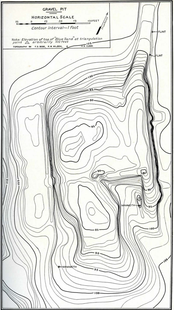
Image Number: 13145
Funds were low and the season was about over, so that we returned to Philadelphia with the intention, the following Spring, of making a more intensive examination of this region. Before leaving Clovis, however, we looked over several collections of artifacts that had been made along Black Water Draw, and in these were a number of Folsom and Folsom-like points, of which we give a description later on.
In the Fall of 1932 a road construction company, looking for supplies of gravel for the new road being constructed between Clovis and Portales, opened up one of these old lake beds, and thus exposed a face through the bluish-gray sands well down into the gravels, and in one place to standing water below. In carrying on these operations they encountered quantities of animal bones in the “blue” layer, and the Engineer in charge, Walter Burns, communicated with George Roberts, who in turn relayed the information to us. As a result we made another trip to Clovis in November of the same year, spending most of the time at this gravel pit.
The following year, 1933, we were in Clovis again and spent the entire summer there, under the joint direction of the University Museum and the Academy of Natural Sciences of Philadelphia. J. McGee and R. Whiteman worked with us all summer. During the early part of the season Dr. John C. Merriam, President of the Carnegie Institution of Washington, visited the site and through his interest made it possible for Dr. Chester Stock to organize a party from the California Institute of Technology to cooperate in the work. This party consisted of F. D. Bode, R. W. Wilson, and D. Curry. Dr. Merriam later in the summer also arranged and made possible the visit to Clovis of Sir Arthur and Lady Smith Woodward, of London, England, and Dr. V. Van Straelen, Director of the Royal Museum of Natural History in Brussels.
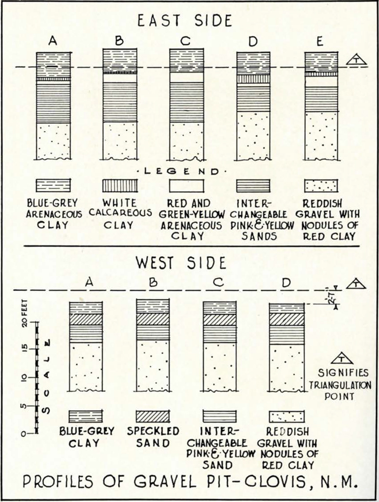
We shall now consider in more detail the gravel pit [PLATES XVIII, XIX, and xx], and a series of basins given the name Anderson Lakes, [PLATE XXI]. The gravel pit opened by the road construction company, above noted, gave opportunity to study the underlying geological section of what was more or less typical of all the basins or “blow-outs” in that area. At the bottom of the vertical sections exposed at the pit is a reddish sandy clay, that lies at the water-table level, about seventeen feet below the top of the blue sands. This grades into coarse reddish and yellowish gravels containing good-sized pebbles, sandy concretions, and clay balls. Above this are fine interchangeable yellowish and pinkish sands interspersed with thin gravel layers, here and there cemented. Above these sands are caliche-like deposits on the east side of the pit and replaced on the west side by a speckled sand. The caliche-like deposits vary from a white calcareous clay to red and greenish-yellow arenaceous clay. Next above are gray and bluish-gray clay or silty sand. Finally above this, where not blown off by the winds, is the brownish top soil. We took measurements of these layers at several stations along both the east and west side of the gravel pit (see PLATE XIX). It will be noted that the caliche deposits are not uniform everywhere at the pit, and also that the yellow and pinkish sands replace each other horizontally several times around it. The triangulation point was arbitrarily fixed at one hundred feet, as marked on PLATE XVIII.
The finer sands may mark a slackened force in the erosional and depositional processes, culminating in deposition under more or less stagnant conditions, eventually drying up completely, and being covered by wind-blown material of recent origin.
The bluish-gray sands represent the chief interest to us since these are the bone-bearing strata. The photograph PLATE XX taken by Dr. Ernst Antevs in 1934 shows a section along the east wall of the pit of the bluish-gray sands. The upper part shows a distinct break where the darker bluish sands come in contact. This darker layer forms a less distinct, but nevertheless perceptible, contact with a lighter layer below, and the bottom of this third bluish-gray layer shows a sharp contact with a light colored caliche. PLATE XX shows the three bluish-gray bone-bearing deposits together. In the other lake beds these blue-gray sands are easily discerned, though, as is to be expected, variations in thickness of the deposits occurs.
A mechanical analysis of these sands was made by A. W. Postel of the Geological Department of the University of Pennsylvania, and a separate paper is in process of publication by him on the subject. The analysis of samples from the bluish-gray sands from the different lake beds showed approximately fifty percent clay and fifty percent fine sand with silt predominating. The grains were subangular, and appeared to be chiefly water-deposited; some were frosted. There was a general similarity all through the analyses from the area that leaves little doubt that the conditions, under which the sands were deposited, had been the same. The heavy mineral separations confirmed this conclusion as did also the types of inclusions in the quartz grains. Minerals with special optical or physical features, according to Postel, such as pink zircon and garnet, showing strain polarization, were present in all the samples identified.
Samples of the bluish sands were turned over to Dr. Kenneth E. Lohman of the United States Geological Survey for a report which he very kindly made of the diatoms found in them. His report follows.
Diatoms from Quarternary Lake Beds near Clovis, New Mexico, by Kenneth E. Lohman22
The following 18 samples were collected by Mr. Edgar B. Howard, of the University of Pennsylvania, during his archaeological excavations in the vicinity of Clovis, New Mexico
- Pit, east side, top of blue sand.
- Pit, east side, middle of blue sand.
- Pit, east side, bottom of blue sand.
- Pit, west side, top of blue sand.
- Pit, west side, middle of blue sand.
- Pit, west side, bottom of blue sand.
- Anderson Lake, #2, Erosion Island, top of blue sand.
- Anderson Lake, #2, Erosion Island, middle of blue sand.
- Anderson Lake, #2, Erosion Island, bottom of blue sand.
- Anderson Lake, #2, North side, blue sand.
- Anderson Lake, #2, West side, blue sand.
- Anderson Lake, #2, South side, blue sand.
- Anderson Lake, #2, Northeast side, top of blue sand.
- Anderson Lake, #2, Northeast side, bottom of blue sand.
- Anderson Lake, #3, top of blue sand at site of mammoth.
- Circus Lake, top of blue sand at site of mammoth.
- Garrett Lake, top of blue sand at site of mammoth.
- U. S. Lake, top of blue sand at site of mammoth.
A total of 89 species and varieties of diatoms were found, 68 of which are living at present in fresh water lakes and streams and 21 are living sparingly in fresh water lakes, but more frequently in saline lakes and brackish estuaries. As all the species are living at the present time at about the same latitude, a late age is suggested for these beds, probably late Pleistocene or even Early Recent. On the basis of the relative abundance with each other the tentative correlations shown in Table 1 are offered. As a further check on these correlations, and also to provide some idea of the environmental conditions prevailing at the time of deposition, a study of the ecologic conditions represented by the various assemblages was undertaken. The percentage of species living in both fresh water and saline (non-marine) waters was determined for each sample and indicated on Table 1. In computing these percentages the different species have been weighted according to their abundance.
Table 1 – Tentative Correlations
| Pit | Anderson Lake | ||||
|---|---|---|---|---|---|
| East side | West side | Erosion Island | North side | West side | South side |
| 1 35% |
4 35% |
||||
| 2 25% |
5 25% |
7 29% |
10 25% |
11? 57% |
12 17% |
| 3 25% |
6 15% |
8 53% |
|||
| 9 – |
|||||
Note: the upper figure in each bracket is the sample number and the lower figure is the percentage of species living in saline waters.
In the “Pit” samples, an increase in salinity from bottom to top is indicated, which suggests an increasing aridity of the region with consequent evaporation and concentration of the water in the lake. In the Anderson Lake samples, the picture is not so clear. Samples Nos. 7, 10, 11, 12 seem to fit into the same horizon as Nos. 2 and 5, on the basis of correspondence of species, and with the exception of No. 11, the indicated salinity is in fair agreement.
An anomalous situation is presented by the high salinity indicated in sample No. 8, which would suggest that the beds on “Erosion Island” represent deposition under decreasing aridity, rather than the reverse, as indicated for the “Pit” samples. Only one whole diatom and one fragment was found in Sample No. 9, so no information of value could be obtained regarding it. It is quite possible that this decrease was only temporary and that an examination of beds overlying the ones studied would indicate an increase in salinity. Samples were not available from these higher beds, however, so this must remain pure speculation for the present. The high salinity indicated for Sample No. 11 is also somewhat anomalous. This sample contains the highest percentage of saline types of any of the samples studied and the correlation is questioned on this ground, although equivalence of species would place the bed as shown in the table.
————————
Samples of the bluish-gray sands were also sent to Dr. Paul B. Sears for determination of any pollen that might be found. Quoting his report he says: “Aside from stray grains of pine and amaranth which might have come in from considerable distance, I regret to say that we have found no pollen. In a number of layers, however, charcoal occurs, as you no doubt have already determined by other means.”
In spite of the disappointing results of the pollen analysis of samples from Clovis, the subject is important in a problem of this kind, and good results have been obtained, particularly abroad. For example, in Ireland, at the classical site for finds of the Irish Elk, the stratigraphy shows clearly a climatic oscillation in the period between the melting of the last inland ice and the beginning of the Post-Glacial birch period.23 An interesting table has been arranged by C. B. Whelan showing the relation between pollen-analysis and Irish pre-history.24 Pollen analysis is thus an additional aid in trying to solve the sequence of climatic changes, and may provide the investigator today with a scale for dating his cultural stages.
Invertebrates occur in all the old lake beds throughout the bluish sands, but concentrated nearer the upper end. Dr. H. A. Pilsbry of the Academy of Natural Sciences, Philadelphia, has identified the types as follows.
Report on shells collected by E. B. Howard from lake bed southwest of Clovis, Roosevelt Co., New Mexico, by Henry A. Pilsbry
Image Number: 13143
- Lymnaea palustris nuttalliana Lea.
Large, well developed specimens, up to 40 mm. long. Abundant. - Helisoma trivolvis (Say).
Also large for the species, up to 28 mm. diameter. - Helisoma anceps (Mice.).
Up to 7 x 13 mm.; cavity of left side wider than in the living New Mexican form. - Gyraulus parvus (Say).
Only three quite young specimens washed out of mud in the larger shells. - Physa, undetermined.
One very young shell, with the preceding species. - Sphaerium, species probably new.
Valves of a rather large species, length up to 15 mm., near S. modestum Prime, but apparently distinct from that or from any species I have seen from New Mexico and neighboring states. Probably undescribed. The same species was found in a deposit containing mammoth bones, on Salt Creek, Culberson Co., Texas. - Pisidium, species not determined.
Three minute valves, 1 to 2 mm. long, were washed out of the mud in larger shells. They are too young to be determined.
The Lymnaea of this deposit is the same form that has been found in deposits in the Texas panhandle, Swisher Co., and in Hardeman and Stone-wall Counties further southeast. This species is, according to F. C. Baker, confined to the Boreal and Transition zones. This is confirmed by the data given by Junius Henderson, and by my own observations. It is not known to occur living nearer than from 200 to 300 miles north and west. Baker has plotted it as occurring in the extension of the Rocky Mountains into Northern N. M., and Prof. Junius Henderson has found it in Conejos Co., Colorado, and northward through the higher parts of the state. It is also reported from the mountain region (Boreal and Transition zones) of New Mexico west of the Rio Grande, but whether actually living there could not be ascertained. This is about 200 miles west of Clovis, and in a distinctly higher life zone.
The presence of this species fossil in southeastern New Mexico, in a region near the junction of the upper and lower Austral zones, indicates widely different former climatic conditions from those now prevailing there, and leads to the conclusion that the deposits date from Glacial (Pleistocene) time. The shifting of isotherms through several hundred miles can hardly be interpreted in any other way.
The presence of large forms of Helisoma trivokis and H. anceps confirm this conclusion. Such forms now occur in colder, Transition to Boreal zone localities. The modern forms of these species in that region are H. trivolvis lentos (Say) and a different, smaller, race of H. anceps. The occurrence of a Sphaerium differing from any species known living in the region, and apparently extinct, is another indication of Pleistocene.
————————
Bits of charcoal from a hearth in the bluish-gray sands were sent to Dr. R. W. Chaney of the University of California. He reports that the two specimens sent to him are referable to Sapindus (Wild China tree) and Sambucus (Elder). Dr. Chaney concludes: “On the basis of these two genera the generalization may be made that the climate at Clovis during the time the wood fragments were accumulated was similar to that in the Mountains of New Mexico and Arizona at the present time.”
Regarding the identification of the vertebrates, Dr. Chester Stock of the California Institute of Technology has been working on this phase of the problem, but his report is not yet available. Nevertheless, the following information can be given : Bison and elephant bones occur in the blue-gray sands in all old lake beds investigated, and in many of them, including the gravel pit, horse and camel bones were found in the top of the next deposit below the bluish sands—in the yellowish or speckled sands or at top of the caliche where these sands are absent. Horse and a few bison bones were recovered from a point well down in the yellow sands on the west side of the gravel pit. These and a few small rodent teeth found in the pink sands on the east side of the gravel pit, and a peccary tooth from the yellow sands on the west side, were the only bones and teeth found below the junction of the yellow sand (or caliche where this is absent) and the blue-gray stratum. In the blue-gray sands at one location in Anderson Lake where these sands appeared to be somewhat deeper than in other places, bison bones were found at a depth of sixty-one inches below the top of this deposit, camel at fifty-one inches, a bison skull at thirty-one inches, and a skunk and turtle at twenty-five inches. A decalcification had taken place in the bones, but they cannot be said to be mineralized. They were, therefore, fragile and their removal tedious.
Elephant bones, teeth, and tusks, were found weathering out of the top of the bluish-gray sands in every lake investigated, as were those of bison. PLATE XXVIII shows a large tusk, badly weathered, that was uncovered by the wind in one of the old lake beds of the series of Anderson Lakes, that we named “Elephant Tusk Lake”. As found, the tusk measured approximately ten feet along the curve, but there must have been twelve inches lacking at the tip.
At the gravel pit mammoth bones were found in three places, only two of which are marked on the diagram, PLATE XVIII. The third location was just at about the point taken for triangulation purposes, and the mammoth bones found here were first thought to have belonged to those shown just southeast of the triangulation point, but it later proved that we had bones of more than two individuals, so that at least three mammoths were buried at the gravel pit. None of these mammoth bones went below the bluish-gray sands. Those south-east of the triangulation point were only six inches below the top of the blue sands as found here, and the lowest part of the leg bones and pelvis were approximately two feet above the red underlying caliche. Nowhere did mammoth bones seem to extend to the bottom of the blue sands. No mammoth bones seemed to be burned.
At another old lake, that we called “Windmill Lake” [PLATE XVII, 8], were found mammoth bones partly exposed at the surface, and those that had not weathered away completely were only a few inches below the surface of the blue sands. In this particular lake bed the wind had not eroded the sands as in some locations, and sparse grass was still growing here and there. At this spot there must have been a rather complete skeleton judging by what we recovered and by evidence of weathering away of the tusk and other parts. As it was, we took out a large femur and a tibia that were articulated when we uncovered them, lower jaw and teeth, part of upper jaw, and fragments of skull, vertebrae, ribs, and a foot, with metapodials and phalanges articulated.
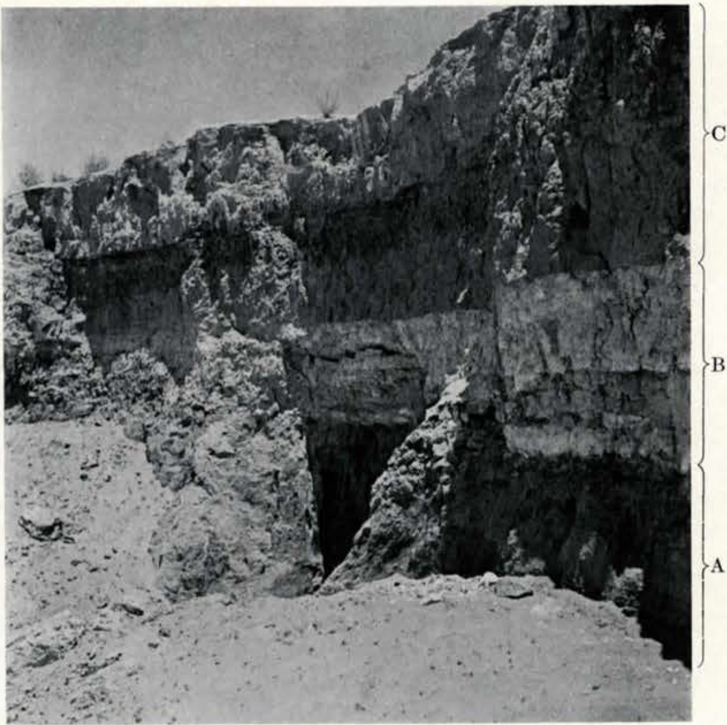
A. Pinkish sands; B. Calcareous clay; C. Bluish-gray silty sands (bone bearing strata) 3 1/2 – 4 feet.
Image Number: 141373
Bison bones also occurred in most of the lake beds, weathering out of the surface of the blue sands as did those of the mammoth. They were also found below the top of the blue sands, and, at the gravel pit, which offered an opportunity to see how deep they went in this deposit; we found that they extended all the way to the bottom of the blue-gray sand, and in one place on the west side we found two bison vertebrae in the yellow sand. Bison bones were more or less concentrated in the upper blue stratum, and were found in such masses that it is perfectly evident that these animals died there in enormous numbers. The road company, in order to reach the gravel below, removed great quantities of bison bones, which together with mammoth bones in smaller quantities have probably gone to make up part of the highway between Clovis and Portales. Some leg bones of bison found on the east side of the gravel pit were perfectly articulated—phalanges, and metapodials standing in upright positions.
Here in these lake beds the horse seems to have died out before the blue sands were deposited, as no remains were found above the surface of the caliche where the blue sands had been blown down to that level. Few camel bones were found—all in Anderson Lake. At one point camel bones were removed at fifty-one inches below the top of the blue sands, and in other cases lying on top of the caliche, so that it was uncertain whether they had weathered out of the caliche or been let down on it from the lower part of the blue sands that were blown away. At any rate they appear in one place in the blue sands, and they may or may not have also been associated with the caliche.
We shall now examine the associations with human artifacts that occurred at these sites near Clovis. First of all we should mention those that we cannot prove, but which are, nevertheless, significant in that they agree with others that we offer as evidence of direct association of extinct animals and artifacts. To take up these associations at the gravel pit first: when the workmen of the road company began their work of securing gravel, they used two-horse scrapers, and when they reached the bluish-gray deposits they piled up the material along the edges. In the course of these operations one of the workmen ploughed up a mammoth tooth and the implement (#33-36-11) shown on PLATE XXIX. This artifact was secured by George Roberts and given to the University Museum by him. The blade is extraordinarily thin—one-eighth of an inch at its maximum thickness. It had been broken, but it was not a new break. The entire blade was covered with a limy encrustation, most of which the workman removed. The blade was the only one of its type found in that area, and for its size (four inches long to the break, and two and a quarter inches wide) represents remarkably fine work. The workman, whose honesty I do not question, showed me the spot where he had ploughed up the tooth and this artifact, and there is no doubt in my own mind that they both came from the blue sand on the west side of the gravel pit. The specimen shown as 6 in PLATE XXX came from the blue sands at the pit and was discovered in the fall, after completion of the work in 1933, by one of the boys who had worked for me during the summer. Still another one, a leaf-shaped blade of quartzite, came from the blue sand and still has some of it adhering to it.
We found a number of other points in and on the dumps of blue sands around the edges of the gravel pit. All were leaf-shaped blades, none were Folsom, several were Yuma types. Two of the latter showed fine chipping similar to the specimen shown as 3 in PLATE XXX.
On the east side of the gravel pit at points marked “flint” on PLATE xviii we found associations in situ that we decided not to disturb till we could have competent witnesses to see them. While we were uncovering a large bison horn core and other bones, we saw the edge of a piece of flint among the bones. We immediately advised Dr. John C. Merriam of this fact and of other similar finds in Anderson Lake. The result was his visit in company with Drs. Smith Woodward, Van Straelen, and Stock, as already mentioned. Visits were made to all of the important locations, most of the time being spent at the gravel pit and at Anderson Lakes. At the pit we uncovered the bison bones and the artifact—Dr. Woodward removing the artifact, for such it proved to be. It is a knife-like scraper (#33-36-5) and is reproduced as 4 in PLATE XXXI. Both the point and the bison bones were in the bluish sands, as were all the other bison bones, that is, below the upper contact with recent aeolian sands above. Evidently there had been a fire at this place, for charcoal was found in the deposit as well as burned bones.
At Dr. Merriam’s suggestion, the following notes were made at the time: “Dr. Van Straelen stated that the implement found (field number 334) was in the blue sand. Dr. Smith Woodward agreed by saying that there was no question about it. Lady Smith Woodward also examined it, saying there was no doubt that it was in the blue sand. Drs. Merriam, Woodward, Van Straelen, and Stock agreed that it was contemporaneous with the bison bones. Dr. Van Straelen said that the blue sand at the pit represented, in his opinion, a shallow water deposit, and that the hearth could have been near the edge of the lake. Dr. Van Straelen further said that the bison bones gave the impression of the animals having trampled upon each other in search of a dwindling water supply, and compared this picture with the water-holes in the Belgian Congo where similar occurrences can be noted today among the antelopes around water-holes.”
Osborn25 refers to a somewhat similar case when, during the winter of 1899, in Patagonia, enormous numbers of guanaco sought Lake Argentino and died of starvation upon its shores, having sought drinking-places, during the severity of that winter, where large masses of water were likely to be unfrozen.
Quoting from a lecture given by one of the Trustees of the Academy of Natural Sciences of Philadelphia, the late Prentiss N. Gray, who had made a study of Bison, pointed out: “In 1887 a herd of 4,000 (buffalo) tried to cross the South Platte River when the river was low. Soon the leaders were stuck in the mud, those behind, pressed forward by the herd, trampled over their struggling companions until the whole bed of the river a half mile wide was filled with dead and dying buffalo. This habit of stampeding was a habit of the wild buffalo. They followed their leaders and these leaders once started lost the power of stopping or even turning aside because they were crowded by those behind. This often carried the whole herd over cliffs or into quick-sands to their destruction.” Many similar occurrences were common.
An artifact (#33-36-8) somewhat similar to #33-36-5, shown as 2 in PLATE XXXI, was also found with bison bones, in place, a few feet south of the first mentioned occurrence. Several small chips were found in the blue sands as well as along the east side of the pit. Bison bones were very plentiful at these locations in the pit, and it was hard to separate leg bones from skulls and ribs and other parts of the animals. The charcoal and burned bone area must have been rather extensive as we were able to pick up the same kind of deposits on the opposite side of a roadway sloping out of the pit at this point. It should be noted that the bluish sands stand up in straight vertical faces, very much like loess deposits, and that the occurrences we have mentioned were well in from the face so that they were definitely undisturbed.
Another flake knife or scraper (#33-36-7) was found on the east side of the gravel pit in place, nearly at the bottom of the blue sands. Two snub-nosed scrapers also came from the pit, one quite heavily encrusted with a lime-like deposit on one side.
Emphasis has been placed on the blue-gray sands for the reason, as pointed out, that the bison and mammoth bones are in this layer—the bison from top to bottom, the mammoth, in no case, appearing to reach to the bottom of the deposit.
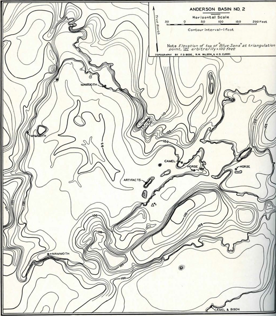
Image Number: 13144
Now to follow these associations in some of the other locations, particularly Anderson Lake, which is more or less typical of the others. Anderson Lake is a series of three basins joined by narrow necks where intervening sand dunes have been cut through. Numbers 10 and 11 on PLATE XVII show the most important of these three. Having found mammoth bones and teeth weathering out of the upper part of the blue sands, as well as bison, and a number of Folsom and Yuma type artifacts having been found on top of the caliche, underlying the blue sand, where the latter had been blown away, our first thought was that this blue sand was the same as that in all the other basins, including the gravel pit. Test holes made in every lake showed the blue sands, of varying thickness, overlying either a caliche like that on the east side of the gravel pit, or yellow sands. For example, in “Erosion Island,” marked on PLATE xxi as “artifacts,” the white caliche was forty-three inches below the top of the blue sands, and the yellow sand was thirteen inches below this. Thirty feet south of here, at a point where the blue sand extends around the basin as a shelf, the caliche was thirty-eight inches below the top of this “shelf” and the yellow sands ten inches deeper. From our triangulation point [PLATE XXI] the top of the blue sand all around the basin was shown to be practically level. While searching this area for evidence, J. McGee located a charcoal deposit with flint points weathering out of the bottom of this “Erosion Island.” This charcoal layer we carefully covered up so that it would not be disturbed till Dr. Merriam arrived, as already mentioned. Here was a definite occurrence, in place, near the bottom of the blue sands, and in these same deposits, all around the lake, one could see mammoth and bison bones weathering out of the top, as much as three feet above. When Drs. Woodward, Van Straelen, and Stock arrived with Dr. Merriam, we uncovered this hearth, and Dr. Merriam took out a number of definitely flaked artifacts that were mingled directly with charcoal and burned bones.
The “Erosion Island” was about thirty feet in length, and, though the top was generally flat, one end had been worn down a little lower than the other. From the top, which was level with the shelf all around the lake, to the top of the charcoal, was forty-seven inches (the blue sand was thicker here than on the other side of the island at the weathered end where it measured forty-three inches, as already mentioned). The charcoal which was compacted into a lens-shaped deposit about forty inches long, thirty-six inches wide, and five inches thick, was less than six inches above the caliche. Bison bones, which were found at all levels throughout this particular deposit, were found in the charcoal, together with burned bird and other small mammal bones (not yet identified). There was no doubt of the association.
As to the artifacts, some of them may be seen reproduced in PLATE XXXII. They are interesting for several reasons. They are all made of small thin flakes and seem to be knives or scrapers (#33-36-107 to-115 for a few of the best). There is not much retouching, but what there is, is fine. One broken snub-nosed scraper (#33-36-114) was found with these. It and several of the flake knives seem to be burned black. Resting on the caliche, in front of this place, were numerous flakes and chips and several Folsom points. Whether these belong to the Folsom pattern or not, cannot be said, since no Folsom point was actually found in place here. It is curious, however, that it is around just such a remnant of the blue sands that one finds the Folsoms in these basins. On the opposite side of the “Erosion Island,” about two feet below the top of the blue sands, bison bones were found in place and among them a side scraper heavily patinated (PLATE XXXI, 3, #33-36-43). What has complicated the problem is that one can also find in these same basins, resting on the blue sands, or on the caliche, where the former have been removed, points of very much more recent date, such as those small triangular shaped ones with notched sides, and sometimes notched bases, so plentiful at Pecos Pueblo.26
One also finds potsherds, and even the fragmental evidence of picknickers and sheep-herders. Anyone of these locations, taken alone, would only tend to confuse the problem, but each one furnished a bit of evidence that, put together, makes the picture clearer, and the Clovis “finds,” when compared to those from other regions, also forms its part of the larger picture. This, in turn, is becoming clearer as field work progresses. How is one going to straighten out this jumble of artifacts in the same basin? One will, with good reason, inquire whether the various types of artifacts have not been let down on to the older surfaces from various levels above, and thus give no clue to the age. One way to get an an answer to this is by a careful study of the area as a whole. For example, it is possible to find camp sites where pottery, small triangular shaped points, and small thumb scrapers are plentiful outside of these basins, and where not a sign of the Folsom or Yuma types are found. It is quite likely that a Folsom or Yuma type has been found, or will be found, at a comparatively recent camp site. There is no reason to suppose that there was not occupation along the edges of these basins, when they held water, or even later, in the basins themselves, when they dried up, and that such occupation took place over a long period, either as camp sites, or as a hunting ground where animals frequented the water holes. Each group or tribe of people would leave its stone implements to be gathered up by those following in their footsteps.
W. E. Baker of Boise City, Oklahoma, has been interested in solving a similar problem in western Oklahoma, and in Dallam County, Texas, just across the line. He has had only a limited time, over a period of years, to devote to his researches, and, at that, has made remarkable progress. Here one finds the same “blow-outs” or basins as at Clovis, and where the upper sands are blown down to the harder layers below, one finds on such a surface the same jumble of artifacts, representing the same types as found at Yuma, Colorado; Clovis, New Mexico; and other similar sites. However, here in Dallam County, Baker has been able to find a great many of these basins, in different stages of erosion, and by carefully noting the types thus associated, over the period of a good many years, he points out that, though he finds practically all types associated, where all of the upper sand deposits have been removed, he finds a differentiation of these types corresponding to the levels to which the sands have been eroded. A section, as he has given it to me, will make this clearer. Using his own designations of types of points, he gives three main levels and further subdivides these into transitional stages as follows:
| Surface | |
|---|---|
| Stratum #3 Silt and sandy loam of a dark color |
Recent artifacts and Plains Pottery Bison bones in association |
| Lower #3 +50% dark soil -50% red sand |
Side and base notched triangular points (“bridle-tops”) Bison bones Leaf-shaped points with constriction above base (“owl-ears”) |
| Upper #2 +50% red sand -50% dark soil |
Few Folsom-like and Yuma types (“ancient” artifacts) Bison remains, and mammoth tooth |
| Stratum #3 Red sand |
Greatest portion of “ancient” artifacts. One complete mammoth skeleton and in five other localities mammoth bones Once complete horse skelton Bison (no mammoth below here) |
| Lower #3 +50% red sand -50% caliche |
Bison, slightly fossilized Horse, camel & bison slightly fossilized on top of |
| Upper #1 +50% caliche -50% red sand |
upper #1 Unidentified fossil bones |
| Stratum #1 Caliche |
Neither artifacts nor bones |
The most common type of artifact seems to be the small triangular one, with slightly concave base and narrow well-defined notches on sides at right angles to the long axis. Associated with them, and found in or on Stratum #3, are snub-nosed scrapers, double-bevelled knives, drills, metates, and mans, and common Plains pottery. None of what Baker calls the “ancient” types, referring to Folsom, Folsom-like, or Yuma types, has been found above sub-division upper #2, as shown on section above.
At Yuma, Colorado, Mr. Perry Anderson and his son have collected several thousand artifacts, largely from “blow-outs” that are quite similar to those near Clovis, and to those just described above, except for some variations in color of the deposits. There is a distinct bluish-black and lighter blue sandy silt, forming the present surface after the upper sands were removed by the wind. These “blow-outs” form a series of basins. In the top of these bluish sands here are found, as in the top of the red sands in Dallam County, some of the same types of shells as are found at Clovis, the identifications of which have been given. No Folsom points have been actually found in place here either. The blue sands at Yuma stand out as “Erosion Islands,” as at Clovis, and in many places a yellowish sand is exposed, where the erosion is deeper. Yuma and related types of artifacts are found on top of the yellowish sand, mammoth teeth and tusks, and bison bones are exposed in the blue. Not associated with the Yumas, and at higher levels, Anderson gets many of the triangular shaped points with notched sides and base, that Baker calls “bridle-tops.”
There are other sites in the Southwest where very similar conditions are reproduced. For example, near Midland, Texas, W. C. Fritz has found Yuma and Folsom types in the sand “blow-outs” near Monahans. While we did not examine this locality as carefully as we have the regions where W. E. Baker and Perry Anderson have worked, our casual observation of it convinces us that it bears the general marks of a geological and archaeological pattern composed of associations of the bison and mammoth in basins that once held water, and from which the overlying sands have been piled into dunes along the edges, and where certain specialized types of artifacts are nearly always found.
We have attempted to show that the basins or “blow-outs” near Clovis produced evidence of the association of artifacts and extinct animal bones, particularly those of the bison. There are a number of such occurrences in this area.
The animal bones were found in a blue-gray silty deposit, containing diatoms and invertebrates. Artifacts were found in these same deposits as well as embedded in these sands or on their surface, and in such positions as to indicate that they were weathering out of these same sands in the same manner as the bones, wherever the blue sands are exposed. Bison bones, some of them burned, were found in hearths, together with artifacts. While mammoth bones were also found in these same deposits, and in some cases at levels of as much as three feet above some of the artifacts, none of the mammoth bones appears to have been burned. Furthermore, it should be noted that we have made no mention of finding any objects made of ivory at any of these locations.
PLATE XX shows three levels of the blue-gray, bone-bearing sands. Hearths in these deposits that held water at one time can be explained in a number of ways, the most obvious and likely one being that the hearths were built along the edges of the water, or during seasonal or longer periodic fluctuations of climate. When the water-holes contracted or dried up, fires were made further out in the middle of these sands. In any case a change of climatic conditions is indicated by various lines of evidence, and on the basis of the types of artifacts found in these basins, and on the palaeontological and geological data, we believe man was contemporaneous with the extinct bison in this region and probably also with the mammoth.
Before inquiring when this was we should consider a number of other factors, particularly those of a geological nature.
21 Udden, et al., 1916. ↪
22 Published by permission of the Director, U. S. Geological Survey. ↪
23 Jessen, 1994. ↪
24 Whelan, 1934. ↪
25 Osborn, 1006, p. 776. ↪
26 Kidder, 1932, p. 20, fig. 4. ↪