The accumulations that mark the progress of a city are closely related to the geological sequence in the earth’s surface. Cities may even be regarded as very recent and very minute parts of the geological record. They are laid down in strata corresponding in their history to the life that successively dwells in them. When this life has ceased to exist they present characteristic outlines and well marked features of the landscape. They then take the outward form of rounded elevations subject to denudation by rain and wind and all the forces that mould the hills and valleys. An ancient city long deserted, like Troy or Memphis, looks like a low hill that by its isolated position and rounded contour betrays its character to the accustomed eye. Excavations made in the hills that once were cities full of life reveal a succession of layers each containing relics of the former population that may be compared to the fossils in the rocks by which geologists determine the age of the different strata in the earth’s crust. The age of each layer in the city hill may be determined by the corresponding traces of the works of man, such as iron, bronze, copper, writings, coins, sculpture, pottery, worked flints.
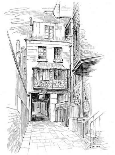
Image Number: 171564
The formation of a city is a result of a congregation of human life persisting continuously throughout a period of time. In its ultimate configuration that formation consists in its substance of the works of man and his bones. The geographical factors that determine the site of a city are themselves closely related to dynamic geology and to forces that are as old as the earth. There is no break in the continuity from the time of the nebula to the deserted city and its obliteration by the forces of erosion. But the period of a city’s existence is so infinitesimally minute that it could not be shown on any possible chart of the geological sequence.
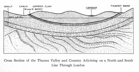
London is a product of the Thames and the history of the Thames valley takes us back to the early part of the Tertiary, called the Eocene. The Thames valley is scooped out of Eocene strata that conform to the layer of chalk on which they rest. This chalk bed is 650 feet thick and above it the Eocene strata attain a total thickness of about 300 feet at London. The lowest of these Eocene strata, the Thanet Sand where it rests on the chalk is two hundred feet below sea level under Charing Cross. Over the Thanet Sand lie the Woolwich and Reading beds 50 feet thick. Then comes the London Clay 142 feet in thickness. The London Clay is capped by the Bagshot Sand of which a patch on Hampstead Heath is all that remains in London. The rest has been removed by erosion.
All of these Eocene beds were laid down in shallow seas. Like the chalk below them they are of marine formation and contain tropical fossils indicating a warm climate. The London Clay is rich in palms, crocodiles, and large serpents. At the end of the Eocene, England had risen above the sea and was joined to the Continent. Owing to this elevation there are no deposits in England corresponding to the middle Tertiary or Miocene. During the late Tertiary or Pliocene, the land still remained above water except a part of the eastern counties which again sank beneath the sea and therefore have Pliocene deposits. Through a valley that is now the English Channel a river of which the Thames was a tributary flowed. Traversing the great plain that is now the North Sea this river entered the Arctic Ocean. The Tertiary ended about five hundred thousand years ago.

The Quaternary is the name given to the relatively short period that has elapsed since the end of the Tertiary. The climate of England which had been warm was turning cold by degrees at the approach of the Great Ice Age. This Ice Age was not a single phenomenon but a series of four glacial periods with warm intervals between, beginning about 500,000 years ago and ending about 50,000 years ago. The first of the ice sheets that have left their mark on the land advanced from the Pole as far as the Thames Valley. When it retreated after many thousands of years the glacier left the land strewn with sand, gravel, clay and boulders, the debris of the mountains over which it had passed during its advance. These deposits choked up the rivers, forcing them to cut their way through or find new channels. In the first Interglacial Period after the first ice sheet had retreated, the Thames was 150 feet above its present level with reference to the land and its valley was much broader than it is at present. Flowing in much larger volume than now, it transported quantities of sand and gravel left by the glacier and, washing them over and sorting them, deposited them on its flood plains. These deposits can be seen today as high as 150 feet above the present level of the river on the high terrace that corresponds to the first Interglacial Period.
As the second ice sheet advanced, Britain sank in large part below the sea that was strewn with icebergs. A glacier again advanced as far as the Thames valley, now submerged below sea level. When in the course of ages this ice sheet retreated, two things happened. England rose again till the land surface stood about two hundred feet higher than at present and another deposit of debris was left on the land. Then the rivers began again their work of cutting through these deposits, and at the same time they transported and redistributed the Glacial Drift on their flood plains. All this time the Thames, like other rivers, was cutting its valley deeper and deeper into the old Eocene beds. During the second Interglacial Period the hippopotamus, the elephant, and the rhinoceros advanced north again and lived in the Thames valley, showing that the climate must have been warm. Their bones have been found where they left them about two hundred and fifty thousand years ago.
In its third advance the ice sheet reached only as far as the Midlands, but the climate was even colder than during the previous periods of maximum cold. The Thames valley with the south of England had then an extreme Arctic climate and was inhabited by the mammoth and the woolly rhinoceros and other Arctic animals. When at last the climate grew warmer again and the third period of glaciation was over, the deposits of glacial debris—sand, gravel and clay—acquired still greater thickness and the rivers were forced to renew their work of sorting out, transporting and redistributing the sands and gravels. In this third Interglacial Period the Thames had cut its valley down to its present level, a distance of more than 150 feet since the beginning of the Quaternary. In fact, during the third Interglacial Period, all of the valleys were about as they are today, but the coast line was very different, for England was still joined to France. The terraces formed by the Thames in successive ages, as it had gone on excavating its bed that grew always narrower and deeper, were more clearly defined in the third Interglacial Period than they are today for they had not been smoothed off or covered with loam. The third Interglacial Period was succeeded by the Fourth Glacier which simply repeated in a general way the action of the others. The third Interglacial Period ended about one hundred thousand years ago, and the fourth and last Glacier ended about fifty thousand years ago. During the Postglacial Period that followed, different things of great importance were taking place. To understand these it will be necessary to have a clear understanding of certain of the events that preceded. The phenomena attending the Great Ice Age with its warmer intervals, embracing a stretch of half a million years since the close of the Tertiary, are extremely complicated, but a relatively simple sequence of events concerns us in particular. It will be recalled that between the first Interglacial Period and the third, the Thames had finished the work of excavating its bed downwards to its present level, a distance of more than one hundred and fifty feet, and that in the course of this major work it was performing also a minor task in conveying the débris of the land left by the glacier, sorting it out and depositing it in the form of beds of sand and gravel on its flood plains at different levels. As the valley deepened and narrowed, its banks presented a series of terraces, corresponding to the Interglacial periods and carrying beds of the Drift. Then the lateral or tributary streams carrying the drainage of the banks cut into these beds, lifted and transported once more the Glacial Drift, shifting it to lower and lower levels down to the present river banks. It is therefore distributed over the slopes of the valley today in deposits of varying size. It should be remembered that in their origin these gravels are of different ages, and that the Thames is much older than any of them. If I understand what geologists have to say of it, the Thames is the oldest river in England, though most of them existed before the Ice Age.
The street called Holborn gives the key to the origin of London. The word is made up of Hollow or Hole and Bourne, a stream. The stream in the hollow. That little stream now hidden beneath the City once started something that led to the founding of London. That was about the time when men first found themselves on the earth not knowing where or what they were, “whence thither brought or how.”
One of the tributaries of the Thames that performed the later work of transporting sand and gravel was this Hole Bourne, called on its lower course the Fleet. During the third Interglacial Period, the Fleet, a larger stream than today, helped to carry down from the upper slopes and deposit along the bank of the Thames a bed of gravel about twenty feet thick. It extends about two miles back from the Thames where it tops a hank nearly fifty feet high. Since the formation of that bed of gravel the Fleet has directed its course straight across the deposit and has there excavated its narrow channel down through the twenty feet of gravel and into the clay beneath. Its chosen course was such that the land on its left bank rose sharply and that on its right bank more gently. Its left or Eastern bank was therefore steep and the land after reaching its maximum elevation fell away gradually towards the River Lea. Where it began to fall away the gravel bed was again intersected by a small stream, the Wallbrook. That gravel bed on the high bank between the Fleet and the Wallbrook determined the exact position of London.
One factor remains to be accounted for, the presence of men. In the third Interglacial Period a race of men roamed the banks of the Thames with the mammoth, the woolly rhinoceros and the Arctic fox. They made implements of chipped flint, rather rudely shaped but requiring a good deal of skill and intelligence. They belonged to the early part of the Old Stone Age in human history. Imbedded in the Glacial Drift on the banks of the Thames are found the remains of their industry of a hundred and fifty thousand years ago. These men were of the Neanderthal race, regarded as a race distinct from and inferior to the one from which we are descended and believed by some authorities to have become extinct in early postglacial time, owing to the pressure of another race that followed the retreating ice sheet of the fourth Glacial Period, moving with the advancing warmth and with the warm fauna from more southern latitudes. This new race was of superior type and intelligence but its characteristic industry, like that of its predecessor, was that of working flint by means of chipping. That industry differs from the preceding simply in showing greater variety and ingenuity. The people of this new race belonged to the upper Old Stone Age of human history and they are called the Cro-Magnon race. They entered England and replaced the Neanderthals between forty and fifty thousand years ago. They had no difficulty in reaching the Thames valley from Europe, for England was still joined to the Continent by a land bridge, an isthmus which, however, was growing steadily narrower.
We are not concerned further with these two races of men. They hunted and fished on the site of London but they were not builders in any sense of the word and they never made for themselves anything like permanent habitations or even settlements that might grow into cities or towns. They appear to have dwindled and declined and some people believe that they disappeared altogether from England before their successors arrived, but there is no necessity for believing in their total disappearance. We now come to a movement with which we are more directly concerned.
About twelve thousand years B.C. an entirely different race made its appearance in western Europe and in its turn invaded the Thames valley. These were the men of the New Stone Age. In addition to a highly developed industry in chipped stone they had developed the art of grinding hard stones to desired shapes. They had domestic animals and they made permanent settlements and cultivated cereals. They came with their herds by the same route as the races that preceded them, for England was still connected with the Continent. But a geological change of the greatest significance was slowly taking place. England was sinking and the encroaching sea gradually altered the coast line. At last the valley of the river into which the Thames had flowed since the Miocene became submerged and Great Britain became an island. The land continued to sink till quite recent times. The English Channel was formed about six thousand years B. C. The Thames was formed in Miocene or Pliocene times, several million years ago, long before there were men of any description upon the earth.
As the land continued to sink, it brought the level of the Thames valley nearer and nearer to the level of the sea, thereby retarding its current and sending the tides farther and farther up its course. Since a river cannot run in a channel that is below sea level, the Thames at the lower part of its course, began to lay down deposits in its bed to maintain itself above sea level. The level of the Thames below the city of London was once some twenty five feet under its present level and the continuation of the Thames valley can be traced for many miles under the sea. Moreover the encroaching ocean converted the mouth of the Thames into a long deep estuary that gives a deep seaway to a point far inland. This situation, affording ready access to the sea from an easily defended point in the interior, was one of the first factors in the making of London.
But another factor was so decisive that it fixed the site of the City to within the fraction of a mile. It you will take an imaginary journey up the river from its mouth about the time of the arrival of Neolithic men, when the Thames already flowed directly into the ocean but a narrowing neck of land formed a bridge to the Continent, the country on either side of the river will present to your observation a low marshy tract, subject at times to inundation. At no point does higher land approach close to the river till you have reached that spot on the north side where a broad and elevated terrace advances to the bank of the river and is cut off on the west by the steep slope that descends to the Fleet. Going up the Thames this bank is the first ground that affords the requirements of occupation. In other words, going down stream it is the last suitable place of settlement. It has already been explained how this bank is topped by a layer of gravel twenty feet thick. That gravel rests directly on the London clay, a stiff tenacious substance impervious to water. The gravel bed receives the rains and absorbs them, and when they reach the clay underneath the absorption is stopped. The gravel therefore acts as a receptable for water and the clay beneath acts as a watertight bottom to that receptacle. Hence the gravel bed is always charged with clear fresh water while presenting a firm dry surface. A well sunk a few feet in that gravel affords a good water supply. Where the London clay comes to the surface in the surrounding river banks and parts adjoining, no water is to be obtained and the ground has remained devoid of buildings till waterworks were introduced. For ages the stored water of that gravel bed was the water supply of London. When that natural supply became contaminated by the presence of the City, holes were bored down through the London Clay to the old Thanet Sand, the oldest of the Eocene strata, lying between the London Clay and the Chalk. Now it so happens that the great Chalk bed is bent like an elongated shallow dish with its bottom directly below the Thames. It is the bottom of a long fold. The Chalk does not absorb water readily and the Thanet Sand, spread over the sides of the fold and sloping in like manner on both sides, is between the impervious Clay above and the Chalk below. It can therefore get no percolation from above and its charge of water is not drained into the Chalk. It gets its charge of water at the points where it comes to the surface, for its curvature brings it to the light and air many miles to the north of London and many miles to the south of London. At these exposed edges the rains are absorbed by the sand and, by force of gravity, are carried down the sloping sides of the dish till they are concentrated three hundred feet beneath the Thames, and are there under pressure owing to the dip of the stratum below and the impervious character of the overlying stratum of Clay. Therefore when holes were first bored at London down about three hundred feet through the London Clay to the Thanet Sand, the water came up with a rush through the bore holes. Thus a new supply of water was tapped and this is still a considerable part of London’s water supply. But the City’s first water supply was the readily accessible store in the surface gravel, that might be tapped by twenty foot wells.
The considerations that determined the site of London were the following. (a) The River Thames. (b) The high bank at the junction of the Thames with the Fleet. (c) The gravel bed that gave a firm dry surface with a ready water supply directly underneath. The first would have been useless without the second and the second would have been useless without the third. It was an ideal site. When the earliest settlers were attacked they assembled with their cattle within their enclosure where they had a water supply that could not be cut off. Moreover they were protected on the West by the steep bank of the Fleet, cn the East by the Marshes of the Lea and on the South by the Thames itself. The first real settlers, the people who first chose the site for permanent occupation, were the people of the New Stone Age, who as I have said, arrived in England about twelve thousand years B. C. At what date they established themselves at any given point we have no means of knowing. We have no reason to suppose that this race ever became extinct and it follows that they form an element in the present population but their blood is very much attenuated and they have disappeared as a distinct type.