This page includes information that may not reflect the current views and values of the Penn Museum. |
INTRODUCTION:
The Priniatikos Pyrgos Project is the result of three decades of fieldwork and research within a 50-square kilometer area of eastern Crete that flanks the central to western side of the broad Gulf of Mirabello1. This recent research has engendered the Priniatikos Pyrgos Geoarchaeological Project and Excavation, which will be described in this web site. References to publications detailing these decades of research are included within the bibliography of this web site. These references are accompanied by references to articles, published and in-process, that describe the current excavation of Priniatikos Pyrgos, the primary harbor settlement of this region, and exploration of its environment.
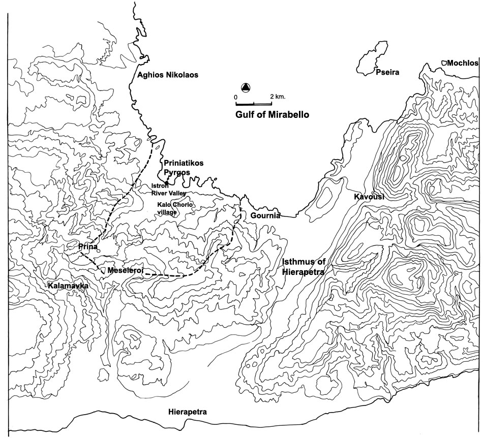
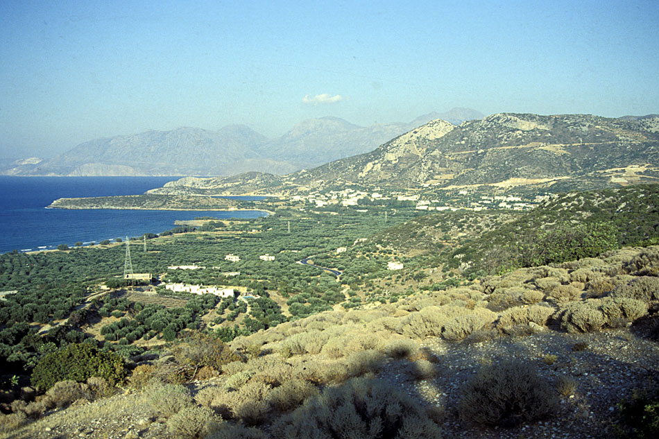
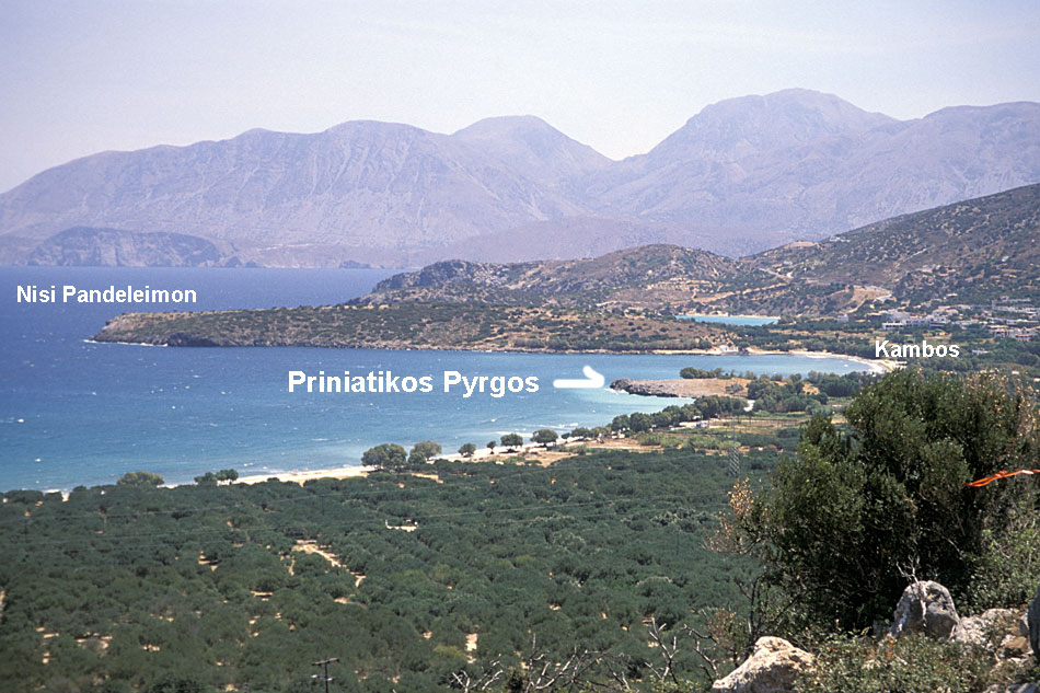
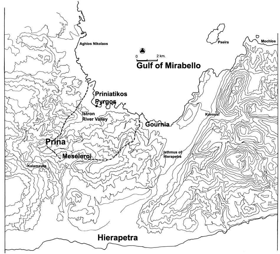
Priniatikos Pyrgos is a coastal promontory located in a broad sandy embayment directly north of Kalo Chorio village and the Istron River valley2. The estuary of the Istron River is located directly east of Priniatikos Pyrgos, set in a rich deltaic floodplain with deep soil, abundant vegetation, and water3. The coastal harbor settlement located on Priniatikos Pyrgos extends eastward, to encompass the next large promontory of Nisi Pandeleimon4, and involves several millennia of occupation, from the Neolithic through the Venetian/Ottoman periods.
The geoarchaeological program and excavation are being conducted through the auspices of the Mediterranean Section of the University of Pennsylvania Museum; The Laboratory of Geophysical-Satellite Remote Sensing and Archaeo-environment, Institute of Mediterranean Studies, Foundation for Research and Technology, Rethymnon, Crete; The Laboratory of Archaeometry, Institute of Materials Science, NCSR, Demokritos, Athens; and the 24th Department of Archaeology, Aghios Nikolaos, Crete. The INSTAP Study Center in Pacheia Ammos, Crete, is the research facility that will be utilized for analyses and storage of finds from the excavation. Generous support for this project has been provided by The Institute for Aegean Prehistory, the University of Pennsylvania Museum, the American Philosophical Society, and the Loeb Classical Library Foundation.

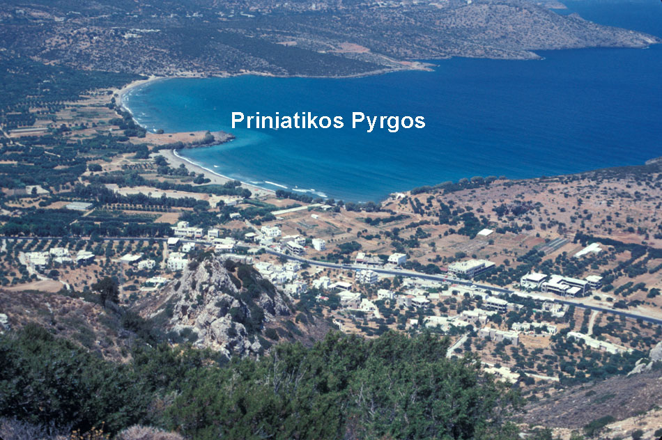
4a. Priniatikos Pyrgos from the West
BACKGROUND:
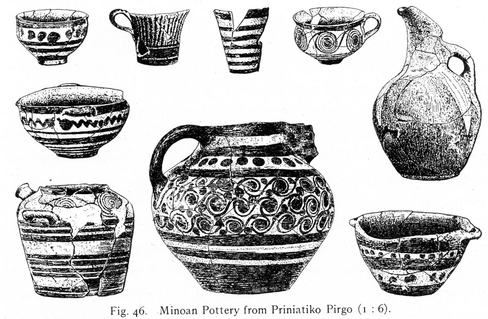
The pioneering work undertaken by Edith Hall (Dohan) of the University of Pennsylvania Museum in eastern Crete (Hall 1914, 1915) centered upon excavation of the Bronze and Early Iron Age refuge settlement of Vrokastro, located on a mountain peak that flanks the Istron coastal zone of the central to western Gulf of Mirabello coast, eastern Crete1. When Hall's work at Vrokastro was completed in 1912, she began a brief excavation on the coastal promontory of Priniatikos Pyrgos, where she believed a Minoan harbor town was located. This brief excavation yielded much fine Minoan pottery that belonged to both the Early and Late Minoan periods (third and second millennium B.C.)2. A large Roman settlement was also discovered built over and damaging part of the Bronze Age town. Minoan vases excavated at the site are part of the Mediterranean collection of the University of Pennsylvania Museum and have been published (Betancourt 1978, 1983).
Seventy years after Hall's pioneering efforts, new research involving an intensive, systematic survey of the Vrokastro region and its environment was begun by Barbara Hayden of the Mediterranean Section, University of Pennsylvania Museum, and Jennifer Moody of Baylor University. The study area extended east-west from the Gournia Plain to the Istron/Kalo Chorio Valley, and south to the upland, inland Meseleroi Valley3. The survey documented the settlement history and environment of the Vrokastro region from the Final Neolithic to the Ottoman periods, and has been published in The Vrokastro Reports 1-3, 2002-5 (see the Bibliography). These sites were identified and dated through clusters of pottery found on the surface, and the environmental framework for these settlement systems was established through studies of plant communities, water resources, soil, and land-use. Greek and Roman inscriptions describing treaties and sanctuaries involving the region provided data concerning the Vrokastro area during historical antiquity. Medieval historical accounts and demographic data were used to interpret the Byzantine through Ottoman settlement patterns established through survey. This in-depth reconstruction of all aspects of life in the landscape established in both broad and specific terms the cultural development of the region.
One additional goal of the Vrokastro Survey was to identify a site within the survey boundaries that could reveal a stratified record of the entire historical development of the region. New fieldwork followed old, for the site selected, based on its size, potential complexity, and millennia-long history, was Priniatikos Pyrgos. Excavation of this primary center will provide stratified contexts by which to more carefully assess regional development and synthesize results of the survey.

ISTRON AND PRINIATIKOS PYRGOS GEOARCHAEOLOGICAL PROJECT, 2002-2006:
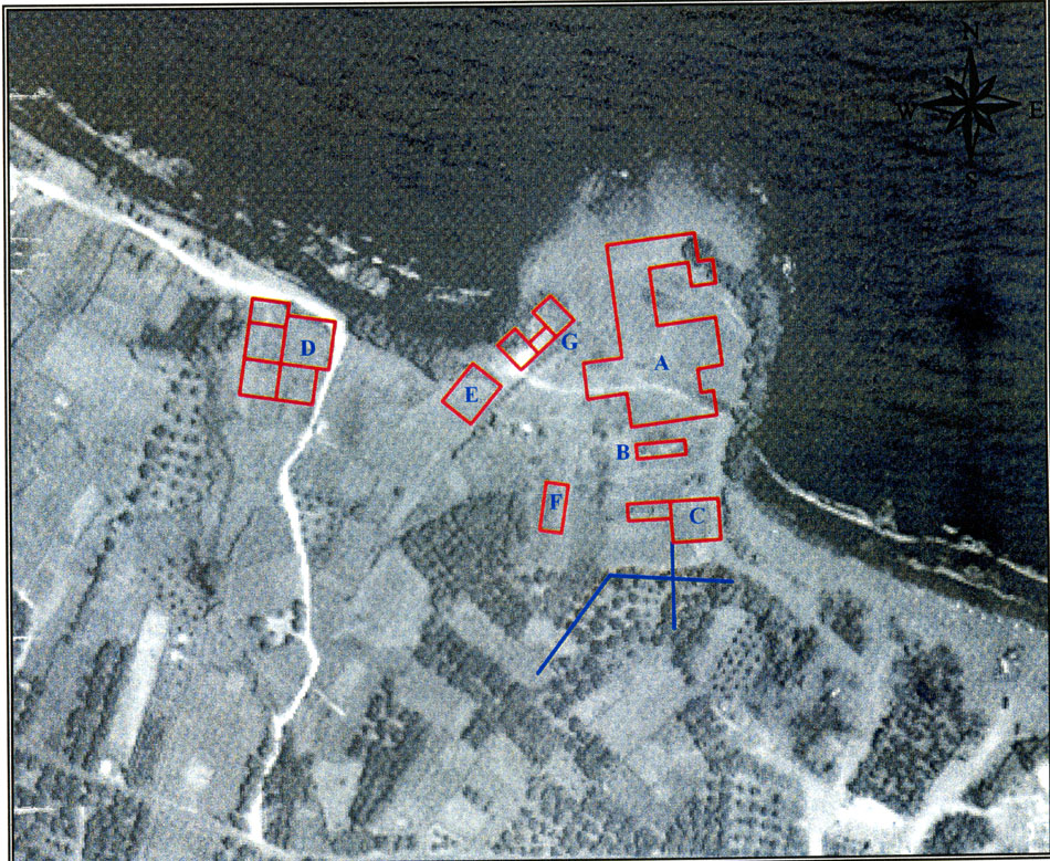
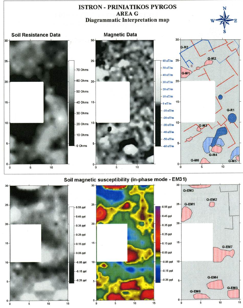
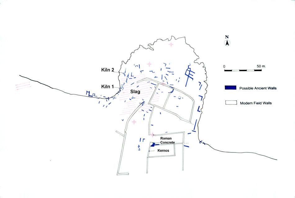
At the close of the Vrokastro Survey Project the primary harbor settlement of the survey region, Priniatikos Pyrgos, was selected for further study. In 2002 the Istron/Priniatikos Pyrgos Geoarchaeological Project was initiated in order to explore the nature and environment of this key coastal settlement. The investigation was implemented through geophysical prospection (remote sensing) and a new fieldwork study of the geology, soils, topography, and resources of the Istron coastal zone. Remote sensing on and near Priniatikos Pyrgos was conducted by Dr. Apostolos Sarris (of the Institute for Mediterranean Studies, Foundation of Research and Technology, Rethymnon)1. Results indicated well-preserved architectural relics, possibly stratified in two phases, especially in grids G and A in the central to western parts of the site2, 3. Dr. Yannis Bassiakos (Demokritos Archaeometry Laboratory, Athens) identified a large iron slag heap on the west slopes of the promontory4, where metal smelting furnaces could utilize the northwest sea winds. Slag also indicated early ironworking at the Early Iron Age settlement of Vrokastro, and in the center of the Greek harbor town of Istron, located on the large promontory of Nisi Pandeleimon, directly east of Priniatikos Pyrgos. The unique regional geology may provide the ore source, as the igneous diorite and granitics ('granodiorite')5 found in Mirabello are accompanied by iron ore in the form of magnetite. Other evidence for pyrotechnical industries on Priniatikos Pyrgos included a possible channel/flue kiln, which was seen eroding into the sea along the western edge of the promontory6. This type of Minoan (Bronze Age) kiln has channels linked to the firing chamber that help to circulate hot air through the kiln. Remote sensing on the promontory of Priniatikos Pyrgos therefore revealed part of an extensive harbor settlement involving long periods of prehistoric and historical occupation, accompanied by an industrial, pyrotechnical function (production of ceramics and metal), which involved both the prehistoric period and historical antiquity.
The potential size of this harbor settlement was revealed through remote sensing in grids established along the coast, east and west of Priniatikos Pyrgos (Sarris unpublished technical report 2003). Remote sensing revealed shallow subsurface architectural relics of probable Greek or Roman date extending to the south and east of Priniatikos Pyrgos, and massive walls under a soccer field in an area called the Kambos, approximately 250 m. east of Priniatikos Pyrgos (Sarris unpublished report 2004)7. Before remote sensing was undertaken in the soccer field area, a series of cores and trenches were excavated to document the topography of the coastal zone. One unexpected result was the appearance of abundant Bronze Age sherds overlying more deeply buried Final Neolithic/Early Minoan pottery. The elevation of the Bronze Age pottery accords with the depth of the massive walls under the soccer field; the Neolithic-Early Minoan phase was deeper, located directly above the water table. These early phases were documented on both sides of the soccer field, suggesting that a large 4th and 3rd millennium B.C. settlement underlies a Bronze Age settlement in the Kambos. Directly east of the Kambos, the Vrokastro Survey Project identified the large Greek harbor town or polis of Istron8.Preliminary results of the Istron Geoarchaeological Project indicated that Priniatikos Pyrgos was part of a much larger harbor settlement, extending to the Kambos and Nisi Pandeleimon, and involves five millennia of occupation, from the Neolithic through the Venetian/Ottoman periods. In terms of lifespan, size, and functional diversity, this harbor site appears primary along the west-central coast of the Gulf of Mirabello. The genesis of settlement here is environment: a rich, well-watered coastal zone and valleys, the nexus of cross-island routes, a protected anchorage, and access to unique regional resources utilized in local industries. These included iron ore, granodiorite used as a ceramic clay temper and in stone tool production, fresh water, clay for ceramics, and fuel for ceramic kilns and furnaces. Topography is also a key factor, as the western slope of Priniatikos Pyrgos, facing the sea winds, is ideal for pyrotechnical industrial activity, and the broad sandy embayments afford an ideal anchorage for boats.

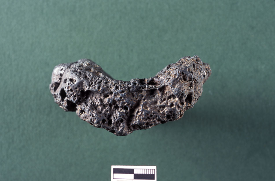

5. Granodiorite

