Ancient Palestine, a small area equivalent to that of Sicily or Vermont, has had in the course of sixty-seven years of scientific archaeology more than a fair share of excavations. The attraction has been the hope, and later the possibility, of linking remains from the earth with events mentioned in the Bible. Since Flinders Petrie first cut into a biblical mound at Tell el-Hesi in 1890, scores of archaeologists from a half dozen western countries-England, France, United States, Denmark, Germany, Italy-have dug the principal sites of Palestine: Jericho, Jerusalem, Samaria, Shechem, Megiddo, Lachish, Gezer, and many other less prominent places. A major contribution to this recovery of the biblical past was made by the University Museum at Beisan, where from 1921 to 1933 the city of Beth-shan was charted through eighteen periods of its long history.
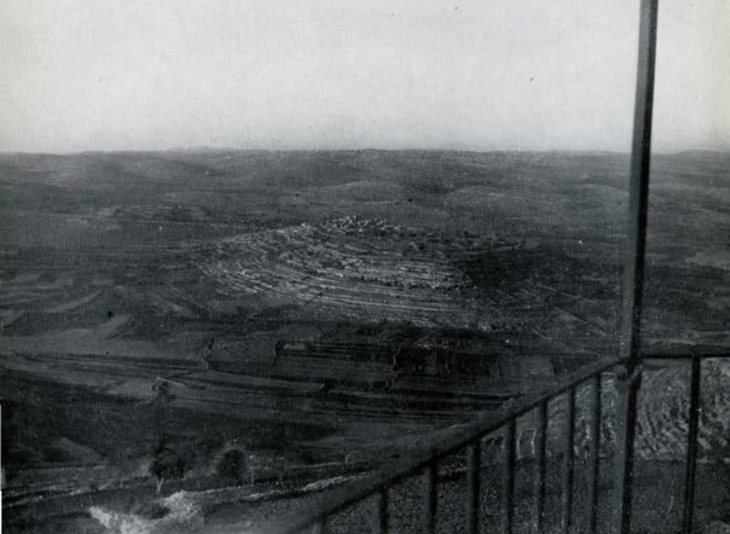

Image Number: 62245
One of the few important biblical cities to escape the attention of the many excavators in Palestine was the ancient Gibeon. Mentioned forty-three times in the Bible, it is connected in biblical tradition with numerous and sometimes dramatic events in Israel’s history. Its people are said to have deceived Joshua, the Israelite conqueror of the land of Canaan, and so to have obtained from him a treaty of peace. Thus their city was spared a destruction such as had been wrought upon Jericho and Ai.
It was here, according to the ancient, but lost book of Jashar quoted in the Bible, that Joshua commanded in his battle with the Amorite kings, “Sun, stand thou still upon Gibeon.” The “pool at Gibeon,” apparently a well-known landmark, is mentioned as the scene of a tournament between the rival forces of Joab, David’s captain, and Abner, the captain of the troops of Ishbaal, Saul’s son. In this gruesome contest twelve swordsmen from each side met death as each man thrust his sword into his opponent. Similarly sanguine is the story of Joab meeting here the traitor Amasa, slaughtering him, and leaving him “wallowing in blood.” The Gibeonites asked for and obtained the privilege of hanging the seven sons of King Saul, after David’s conquest of the former king’s territory. Solomon is reported to have sacrificed on the high place at Gibeon before the completion of the Jerusalem temple, and here he is said to have had the famous dream in which he asked for wisdom rather than riches. The false prophet Hananiah, the opponent of Jeremiah, was a Gibeonite. In addition to the more dramatic episodes there are numerous references in the post-exilic literature of the Bible to the men of Gibeon, some- times by name, and once by a number in a census list.
But where was this ancient city? One hundred and eighteen years ago-on May 5, 1838-an American explorer, Edward Robinson, visited the site of el-Jib, an Arab village eight miles to the north of Jerusalem (see fig. 1 for location). Robinson concluded from the general location and the similarity in sound between the modern Arabic name “Jib” and the ancient Hebrew “Gibeon” that this was the correct location of Gibeon. Although this judgment has generally prevailed, it did not go unchallenged. A leading German biblical scholar, Professor Albrecht Alt of Leipzig, argued some thirty years ago that el-Jib was to be identified with the biblical city of Beeroth and held to this equation in his last publication on the question in 1953, as did Professor Martin Noth of Bonn, another leading geographer of ancient Palestine.
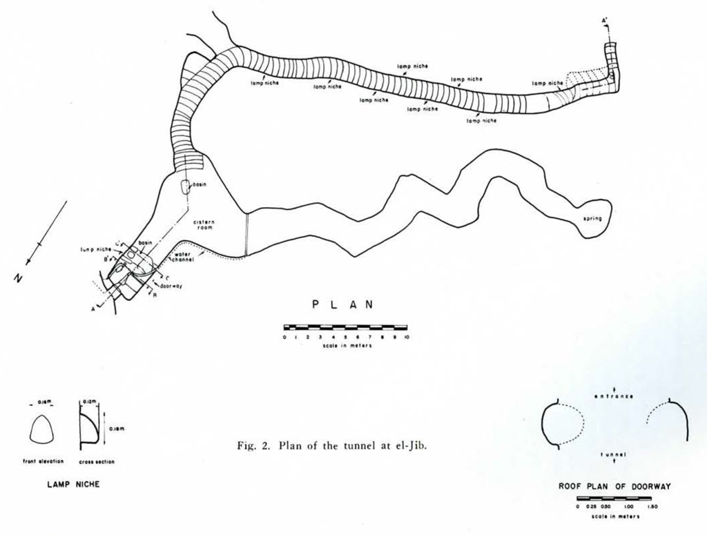
Image Number: 62249
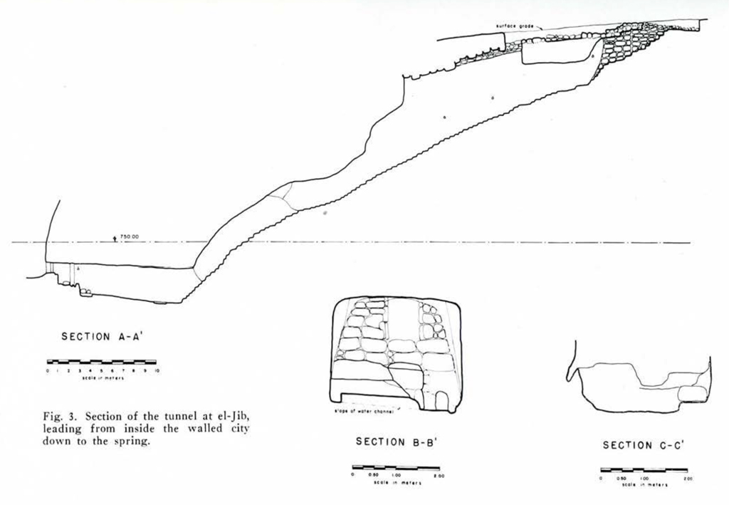
Image Number: 62250
In a search during the summer of 1955 for a possible site for excavation I was attracted by the mound at el-Jib for a number of reasons. Was it Gibeon, as held by American and French scholars, or was it Beeroth, as the Germans had contended? Excavation might make identification possible. But whatever its ancient name this mound, rising more than 50 meters above the plain and extending over an area of more than 16 acres, must have been a strategic and important site in antiquity. Sixteen acres is a relatively large area for an ancient Palestinian city; Tell Beit Mirsim is seven and a half acres, Megiddo is thirteen, Tell en-Nasbeh is eight, Ai is nine acres.
El-Jib is well watered by eight springs, one of which, the spring of the village, still provides water for about one thousand Arabs who live on a mound a short distance to the north of the ancient site. Leading from the spring of the village is a rock-cut tunnel-so it had been reported by a Russian, a Mr. Risky, in 1889 and partly entered by Pere F. M. Abel in 1911; later it had been closed up by a heavy stone wall. This partly explored tunnel of the ancient city could be opened, surveyed, photographed, and studied.
On five visits to el-Jib in I955 I found a number of rock-cut tombs in the sides of the hill, all of which had been opened in antiquity. The Survey of Western Palestine in the l880’s had listed 34 of these opened tombs; quite possibly many more remained unopened. The entire top of the mound was strewn with broken pottery of Israelite date. From the indications of tombs and pottery we were assured of ancient remains of biblical interest even before we began to dig.

The 1956 excavation at el-Jib was sponsored by the University Museum, which, through a grant from the Pew Foundation, supplied the major share of the funds, and the Church Divinity School of the Pacific, which contributed the services of three members of the staff. Funds for purchasing surveying and other equipment were given by the Bates and Rogers Foundation and Miss Margaret G. Rogers. The trustees of the American Schools of Oriental Research put at the disposal of the expedition the archaeological equipment of the Jerusalem School as well as the work room and hostel in Jerusalem.
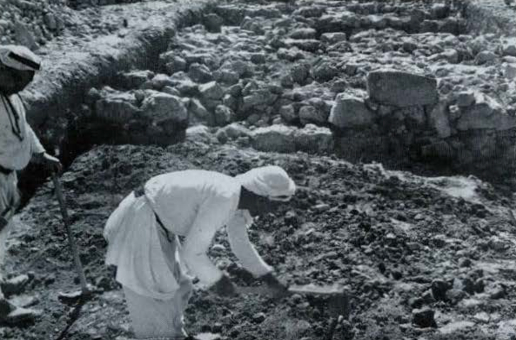
A scientific staff of nine was assembled for the exploratory campaign of 1956.1 Luckily we were able to get seven men from Jericho, who had been trained in a number of seasons of excavation there and at Dhiban, to do the painstaking work with trowel and brush. Just as Egypt has its Qiftis and Iraq its Shergatis, who go from one excavation to another with their highly developed skill in finding floor levels and changes in strata, so Palestine has its men from Jericho who are fast becoming archaeological specialists. The remainder of the working force of an average of 70 men came mostly from the village of el-Jib.2
The season of ten weeks from June 18th to August 24th – with work for six days a week – was broken only by a Muslim holiday and the general strike of one day by which Jordan sought to show support for Egypt during the Suez crisis. Working as close as we were to a military frontier-the Jordan-Israel line was less than three miles to the south-in a time of tension and uncertainty, every precaution was taken to safeguard our records. At the close of each day pottery, small finds, and records were taken to Jerusalem for safe keeping. On days when we were apprehensive at the sound of mortar and machine gun fire along the border we were particularly grateful for the interest and advice of Major Ali Matlaq, commander of the National Guard on that segment of Jordan’s frontier.
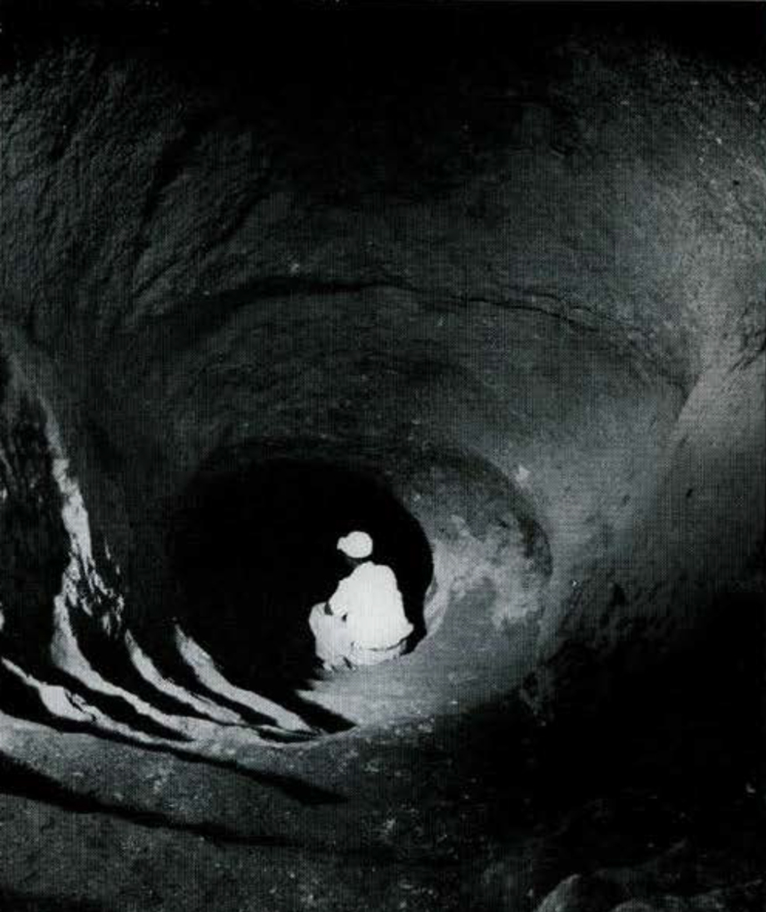
Image Number: 23916a
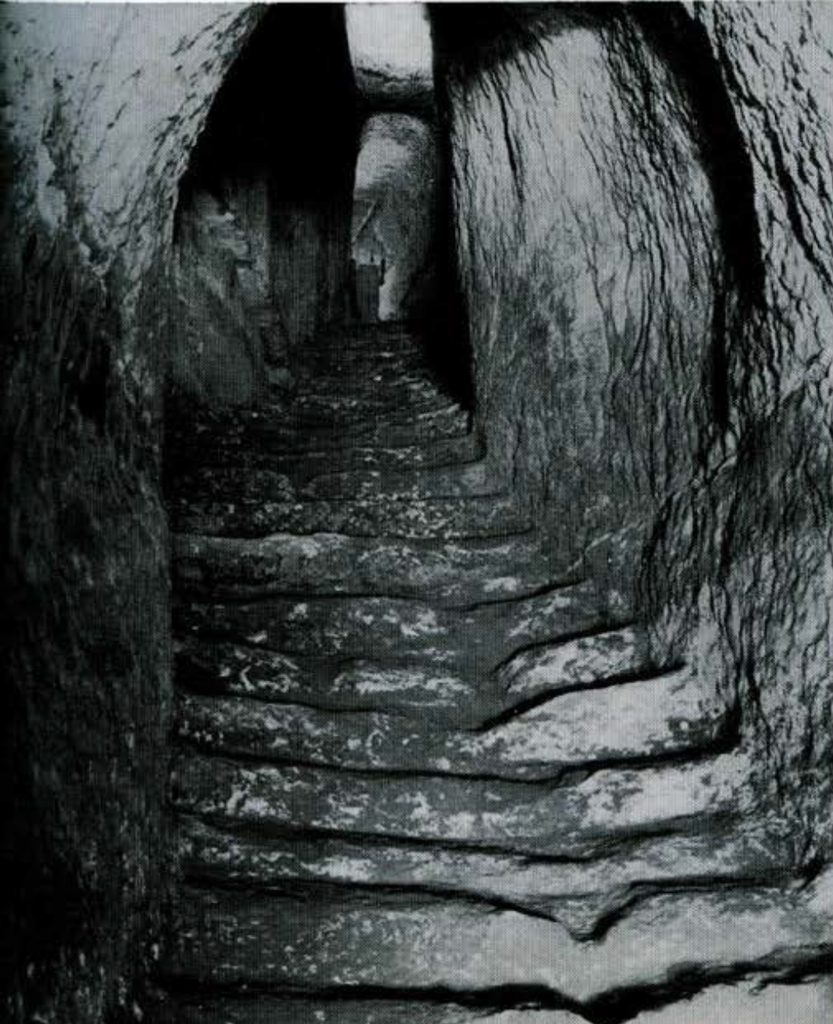
Image Number: 100990
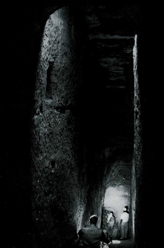
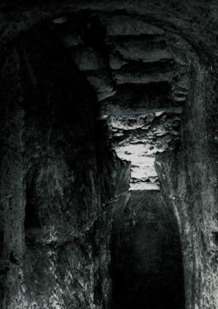
Image Number: 23916b
The decision as to where first to dig into a site as large as el-Jib where no ancient building remains were visible on the surface was a difficult one. Our first choice was an area at the north side of the mound immediately above the spring of the village (Trench III). Occupation at any period, we concluded, should be dose to the water supply. Besides, here we were likely to find the opening to the tunnel.
At the end of the third day of work in this area a pickman opened a small hole which was deeper than the length of his arm. A string with a nail tied to the end was let down until it struck bottom 5 meters below. This hole proved to lead into the main branch of the tunnel of el-Jib, one of our principal finds. Although it took weeks to clear the entire tunnel of debris, we may well describe it at this point as it now appears from a preliminary study.
Tunnel
The tunnel was an important installation for civilian defense. The city wall, to afford the maximum protection, had been placed high on the edge of the hill, taking advantage of the more than 50 meters of the mound’s height above the surrounding plain. But the advantage thus gained was offset by the loss of a protected access to the spring which flowed from the bottom of the mound. In time of siege, when city gates were barred, the defenders were deprived of water. A happy solution to this problem was the cutting of a protected reservoir (fig. 2, at end marked A’) as a cave in the side of the hil1 from which the water flowed and connecting this reservoir with the fortified area within the city wall (fig. 2, A) by means of a stepped tunnel through the solid rock of the hill. In times of attack the defenders had but to block the outside entrance to the cavern reservoir and carry water from the inner opening of the reservoir up the steps of the tunnel to the city square at an elevation of 23 meters above.
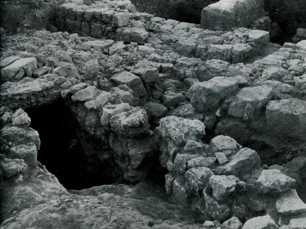

Image Number: 100991
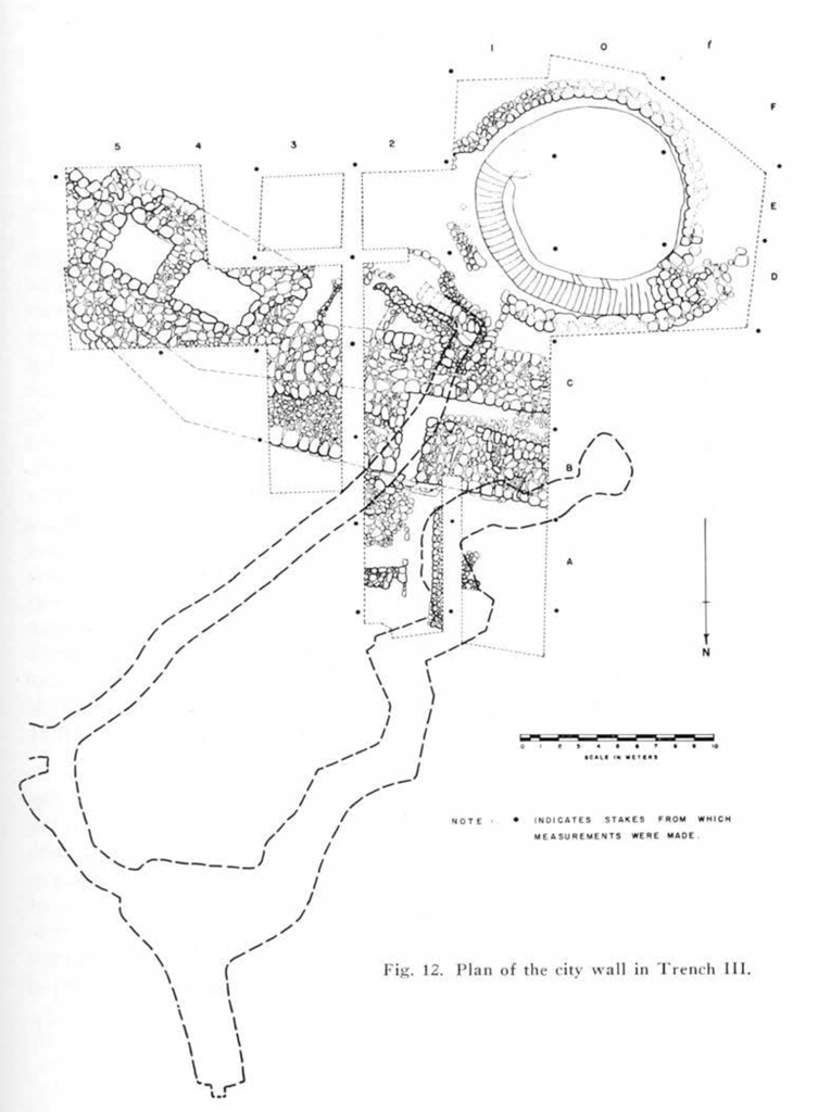
Image Number: 62252
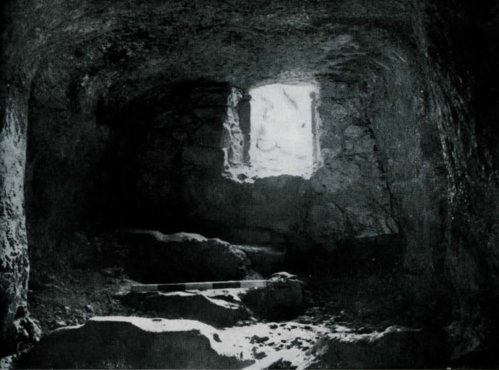
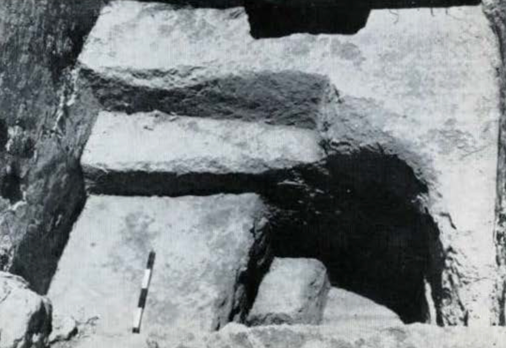
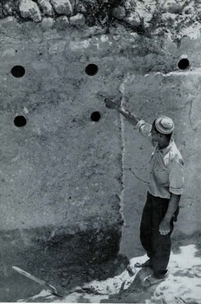
At the north end of the protected reservoir (fig. 2, A) the builders had made provision for blocking the outside entrance against the enemy. Grooves had been cut into the sides and floor of the tunnel entrance (fig. 4). Into these, large stones could be dropped quickly from the inside to form a barricade which the enemy could not easily demolish. While the stones which formed the door had vanished, the grooves in the solid rock leave no doubt as to the general means by which the city water system was protected. A niche was cut into the wall to hold a lamp to provide light when the chamber was closed to the outside.
On opening up the full length of the tunnel we found that it contained 93 steps cut in the rock over a course of 51 meters and that it opened into the city square at a point just one meter and a half inside the double city wall (section of the tunnel is shown in fig. 3). At this point the wall of the city had been enlarged to a total width of 8 meters. The opening to the tunnel from the reservoir on the spring level is round and the steps are steep (fig. 5). As one ascends the steps of the tunnel the first 25 meters of the course is roofed by the solid rock through which the tunnel has been bored (fig. 6). There then comes a stretch of 12 meters (figs. 7 and 8) which was cut not by boring but was trenched from the top of the hill and then roofed over with a false arch consisting of two large stones on each side capped by a third larger stone (for detail of this construction see fig. 9). The average depth of this part of the cutting is 6 meters. At the point where the outside edge of the city wall crosses the tunnel the builders again cut through the solid rock for a distance of the width of the city wall. A few meters before reaching the upper entrance to the tunnel the steps are again roofed over. Finally the tunnel opens into the protected area of the city square (fig. 10).
The boring into the solid rock under the city wall, rather than construction by trenching and a roof, would seem to establish the priority of the wall over the tunnel. If we are right in assigning the city wall, as we are inclined to do at this stage of our study of the pottery, to the 8th century B.C., the tunnel was cut some time after this.

Before the building of the tunnel, access to the spring was had through a small water gate in the city wall (fig. 12, opening in square B-2) slightly more than 1 meter wide. When the tunnel was completed this gateway was closed up with large stones which we found in place. This closed entrance way is additional evidence that the tunnel was cut sometime after the building of the massive city wall.
At regular intervals along the course of the tunnel niches had been cut to hold lamps for lighting the dark passageway; the carbon from one of these could still be seen on the stone above the niche. It is probable, to judge from the wear on the treads of the steps (fig. 7) and polishing of the stone along the walls, where hands had rubbed it smooth, that the tunnel, primarily a defensive measure, served as a convenient access to the water supply in times of peace as well as when the city was under direct attack. While similar tunnels are known from Jerusalem, Gezer, Megiddo, and Ibleam, the one at el-Jib, with its high chamber arched over with a roof, is the most impressive example of this feature of ancient civil defense in Palestine.
As can be seen from the plan of the tunnel (fig. 2) a second and horizontal tunnel had been cut from the protected reservoir, where the spring water collected, to the source of the spring (fig. 11). This boring ran approximately 41 meters into the rock of the hill and ended where the spring issues from a crack in the rock, a point which is just 7 meters from the north edge of the rock-cut pool described below.

Pool of Gibeon
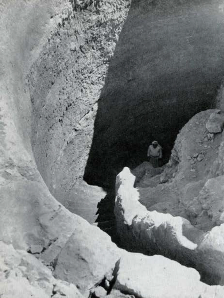
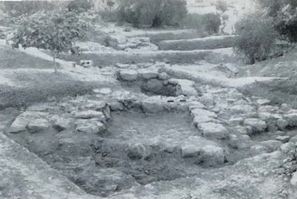
While we were clearing the area to the south of the upper opening of the tunnel there appeared just three meters away the rounded edge of a basin cut in the solid rock. It was guessed, from both the circular shape, suggesting a cistern, and cuplike indentations on the edge for supporting water jars with rounded bottoms, that this was a large reservoir for water. For the remaining seven weeks of the excavation every effort was made to remove the debris from the eastern half of this pool. On the final day of the excavation we had reached a point on the east side 10.51 meters below the rim, but without finding the bottom.
The pool is roughly round in shape, with a maximum diameter of 11.50 meters; the sides are perpendicular. Beginning at the northwest a spiral stairway, 1.50 meters wide and equipped with a guard rail one half meter thick, leads downward around the pool’s edge (fig. 13). Forty-two steps-including five built of stone masonry at the top-were uncovered (fig. 14). The first ten steps at the top evidenced considerable wear; beyond this point, possibly the normal water level, the rock-cut steps showed little use.
A well-built stone wall surrounded the pool, except for a break on the east side. We looked in vain for evidence of a conduit or channel which might have supplied the pool with the drainage water from the slope to the south. If the pool was not filled with surface water, as seems to have been the case, how then was it supplied? There remain two possibilities: either, it may have been fed by a subterranean spring-the present source of the spring of the village is only seven meters to the north of the pool’s edge; or the water from the spring below in the wet season when it flowed freely may have been carried up the hill by slave labor and poured into the pool. There is also the possibility that the “pool” may have been a stair well leading down to a water source at the bottom. Until the pool is completely excavated it is hazardous to venture an opinion.

The debris with which the pool had been filled contained the most important objects found during the 1956 season. Mud, stones, and pieces of broken pottery had washed down from the hill above after the city’s destruction about 600 B.C. As in other areas of the excavation all pottery was salvaged by workmen, put into carefully labeled baskets, washed, and examined at the tent. The pool alone yielded on the average a dozen baskets of broken fragments a day.
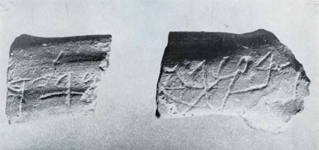
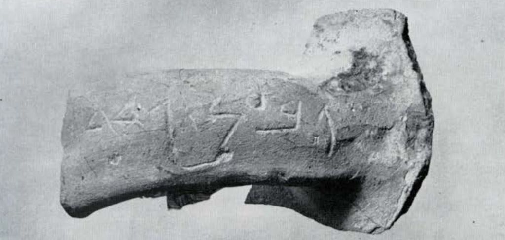
After we had looked over what could be roughly estimated as 35,000 fragments of pottery, there appeared a broken jar handle carefully and clearly inscribed with the letters GB’N in the Hebrew script of the 8th-7th centuries B.C. and two unintelligible letters. The four clear letters are the spelling of the town of “Gibeon” in the ancient Hebrew of the Bible. A day later there came from another basket a piece of the same handle giving in Hebrew letters a man’s name-possibly the owner’s-which is probably to be read Naariah (fig. 15 for both these pieces). Some days later, also from the debris of the pool, came another “Gibeon” handle even better preserved and containing in addition to the name of the town the word gdd (fig. 15). This find made it possible to read correctly the unintelligible letters at the encl of our first inscribed handle. From these three pieces of handles it is now reasonably clear that a citizen of Gibeon in the 8th or 7th century had not only placed his name on his jars, but his address as well. Still another inscription with the first two letters of the word “Gibeon” was salvaged from the fill of the pool.
In all the excavations of Palestine over a period of the 66 years of the history of digging there, never before has the ancient name of a site appeared in this fashion. This discovery now makes the ancient Gibeon one of the best identified sites in all Palestine. Perhaps we are now justified in identifying with a fair degree of certainty the large rock-cut pool at el-Jib with the “pool at Gibeon” mentioned in II Samuel 2:13, where there took place the famous and gruesome contest between the twelve men of Joab and the twelve men of Abner.
Besides the “Gibeon” handles one with the name of “Hananiah” was found in the pool. The name is a common biblical name. Interestingly, one of the men who bore this name is said, in Jeremiah 28:1, to have lived in Gibeon.
In addition to these names scratched on jar handles there were inscriptions stamped on handles when the jars were made. From Palestinian excavations four types of inscribed jar-handle stamps are known. Examples of three of these appeared at el-Jib: “For the king, Hebron,” “for the king, Sokoh,” “for the king, mmsht.” The so-called “Mispah” impression (msh), of which many examples were found at the near-by Tell en-Nasbeh, also made its appearance at el-Jib.
All the inscribed material came from the debris which had washed down the hill into the pool. This sample of significant evidence is a token, we trust, of the wealth of interesting detail which awaits the excavator of the slope immediately above.
City Wall
In the area of the pool and the tunnel (Trench III) we found the best evidence for the city’s defense system. Built of cut stones laid on the bed rock is a heavy city wall 3.50 meters thick, which had been strengthened by an inner wall to a total width of 8 meters (fig. 17). As the wall ran eastward it had been enlarged to include two tower-like structures to a total width of 9 meters (fig. 19). The evidence for date from the pottery associated with the foundation points at the moment to the 8th century B.C. as a probable time for the building of the heavy defense system. On the west of the city, in Trench I, the same city wall was picked up, corresponding in width and construction to the outer wall on the north side (fig. 20). Apparently the vital water system was a vulnerable point and required the heavier fortification.
After recovering the Iron Age walls in Trench III a good deposit of Early Bronze Age (EB Ib) material was reached. In this earliest period, reaching back to approximately 3000 B.C., some walls were of mud-brick, others were of stone. One store room yielded 14 storage jars still in place-and some in good condition despite the pressure of several meters of Iron Age remains which overlaid them. Below the Early Bronze Age remains was bedrock. Nothing earlier was found at el-Jib.
Roman Period
Since one of the objectives of the exploratory campaign of 1956 at el-Jib was the charting of the history of occupation at the site, we made a sounding on the west side of the mound (Trench I). At the west end of this east-west trench, 45 meters long and 5 meters wide, we soon encountered the massive city wall already mentioned above as it circled the west side of the city. But here we found not Israelite occupation on top, but Roman walls which could readily be dated by a hoard of 23 coins which someone had tucked away for safe keeping in the corner of a room. They belonged to the time of Alexander Jannaeus, 103-76 B.C. An interesting feature of this period was a plastered pool or bath with steps leading down to the bottom, which was 2 meters below the surface (fig. 21). The earlier city wall had fallen into disuse in this more tranquil period for city life in Palestine.
The largest reservoir in the long history of Gibeon’s water system seems to have been built in the Roman period. This pool, which was located 36 meters to the northeast of the spring of the village, was partly exposed and had been suggested by former explorers as the site of the “pool at Gibeon” in the time of the Hebrew monarchy. We excavated a portion of this pool, which measured on the inside 11.30 meters by 18.30 meters, to a depth of 2 meters. Four layers of hard plaster covered its walls and bottom, which rested on bedrock. The first and earliest layer of plaster had been applied in the Roman period, to judge from pottery jars of Roman type which had been curiously embedded in the masonry of the wall (fig. 22). Water had been brought into the large reservoir by a conduit from the village spring. The pool had been used through many centuries from the Roman period down through Arab times.
The Nestor of Palestinian archaeology, Sir Flinders Petrie, held that the northwest of any tell was the place to dig in search for the palace or the best part of the ancient town. The prevailing winds came from the northwest; thus, the most desirable building sites would have been at the northwest. Having pitched our work tent at the northwest of the mound we soon discovered that on the hottest summer days there was generally a breeze from the Mediterranean at this spot.
Toward the end of the season we rented 500 square meters of land here and made an exploratory sounding. While nothing like a palace appeared we were successful in adding two entirely new periods to the occupational history of the site. Below the Iron 11 level (800-600 B.C.), which we had found in the other two areas, there appeared a good deposit of Iron I (1200-900 B.C.). Immediately below the Iron I level pottery from the Middle Bronze period of approximately 1800 B.C. was plentiful. A knowledge of the location of the sites of settlements during the period of the Hebrew monarchy and the time of the Middle Bronze Age will be helpful in planning excavations in subsequent years.
Strangely enough the evidence for the Late Bronze city, the Gibeon of the Joshua narratives, has so far completely eluded us. But the area is large and our sampling was in three relatively small sections of the large mound.
ln the first season of work at el-Jib we have been able to identify the site with the ancient Gibeon mentioned in the Bible; the locations of the Early Bronze, the Middle Bronze, the Iron I, the Iron II, and the Roman occupations are now certain. The limits of the city wall of the Iron II period are now fixed on two sides of the mound, and the municipal water system of the city has been traced through about 2000 years of the city’s history. In the light of this definite information the next most profitable endeavor would be to clean the pool of Gibeon to the bottom, a monument which is of interest to all students of biblical archaeology because of its size and spiral stairway, and the probability that it is the landmark mentioned in the Bible.
1 The writer served as director. Sherman E. Johnson, as administrative director, took care of the expedition’s funds, paid workmen each week, and also served as an overseer in various plots, Jean Henkel Johnson, as cataloguer, assumed the tedious job of keeping records. Most of the work of recording was done ar the American School in Jerusalem, a much safer place for finds than the tent at el-Jib. Marcia Rogers, architect, undertook not only the drawing of all sections and plans for Trench II and our major area, Trench III, but proved her general usefulness in supervising laborers and in the making of a sizeable portion of the catalogue of small finds. T. Hartley Hall, IV, photographer, patiently coped with the difficulties of developing, in a dark room without running water, the films from three small cameras which were daily in use at el-Jib, as well as several hundred plates from the large camera. He also supervised laborers throughout the entire season. Subhi Muhtadi, veteran surveyor of many Palestinian expeditions, made the contour map of the site, the plan of Trench I, the plan and section of the tunnel. and many drawings of the profiles of pottery. With us also for varying periods of time were: Robert C. Dentan, Thorir Thordarson, and H. Neil Richardson. Frank M. Cross, Jr., who was in Jerusalem on the Dead Sea Scroll project, very kindly lent us his expert aid when examples of Hebrew epigraphy began to turn up. Yahshan Speer served as foreman for about half of the season. ↪
2 Sami Meddah, of the Department of Antiquities in Jerusalem, was of great help to the expedition in making agreements with eight different landowners for the rental of land at el-Jib and in the difficult matter of fixing compensation for trees and vines which had to be destroyed. We also had the help of G. Lankester Harding in making preliminary arrangements both in 1955 and in 1956. Fais Hassan Abed Rabbo, the mukhtar of the village, was also of assistance. ↪