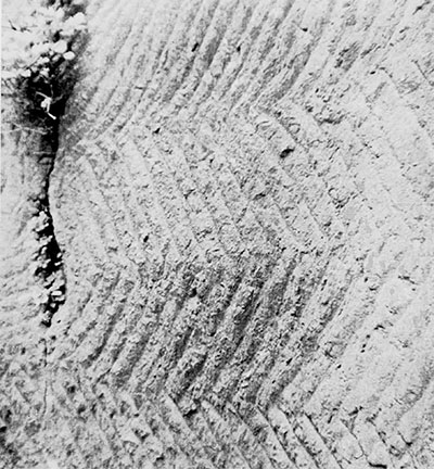
A unique and fascinating portion of one of the finest aqueducts of the Roman world will be lost in the next few years to the march of progress, doomed to disappear under the waters of a new dam in Southern Turkey. The portion that will be flooded, about six kilometers from the beginning of the system to where it emerges from the Taurus mountains onto the ancient Pamphylian (modern Antalyan) plain, includes a dozen segments, several hundred meters in all, of magnificently engineered tunnels and troughs hewn into the side of a sheer canyon wall. Some of the tunnels are of monumental—and inexplicable height and almost all of the clean-cut rectangular passages remain in a fine state of preservation, the herringbone patterns of the chisel marks only slightly softened by the passage of water and time.
About thirty kilometers in its entirety, the aqueduct leads from a gorge of awesome beauty where the milky-green Manavgat (ancient Melas) river bursts torrentially through a narrow gorge, not twenty meters wide, in the Taurus. Though a relatively short river, the Manavgat carries a larger volume of water than any other in Asia Minor; the compression of that huge flood in a sharply falling and constricted river bed between towering cliffs makes for a formidable, almost terrifying spectacle. For many miles above the gorge the cliffs impinge so steeply on the banks as to permit no habitation near them; the Romans could be sure that they had uncontaminated water at the source they selected.
For the two or three kilometers downstream, the river flows swiftly but through a broadened valley. Then it narrows again through a second gorge the width of a football field, at the southernmost ridge of the Taurus. It is here that the dam will be built. Below are foothills through which the aqueduct tunnels or is carried by magnificent arches over valleys and meadows until it pierces the second century B.C. wall of Side, the Queen City of the Pamphilian coast, and where it once ended in its nymphaeum, fountains, and baths.
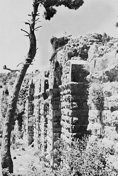
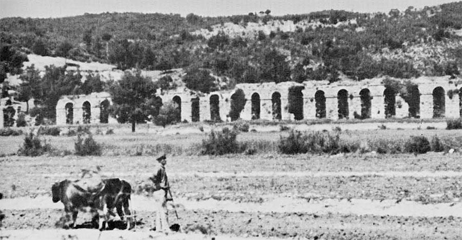
The nymphaeum of that rich, pirate-infested city—a Hellenistic-Roman Sybaris, to judge from the magnificence of its ruined buildings and monuments—appears from its structure and decor to have been built in the second half of the second century A.D.; it can be assumed that the aqueduct is of the same period. Much of the more than twenty kilometers of it over the hills and flatland remains visible today. Some thirty spans across streams and valleys have been identified and one section, 340 meters long and four meters wide, is carried across a stretch of bottomland on twenty arches supported by mighty pillars of rustic-cut stone. Several miles of tunnels and covered trenches can be traced, or even walked through, rectangular where they pass through solid rock, and in plastered, vaulted passages of stone and cement elsewhere.
The portions below the projected dam, of course, will not be affected; happily, visitors will still be able to admire many stunning elements, such as the forty-arch span and a two-story bridge 18.5 meters above one of the Manavgat’s tributaries, that are the equal in beauty and superb construction of some of the finest examples anywhere else in the Roman Empire.
But what will be lost, and what may not exist elsewhere—at least, I have never seen described or even heard of anything like them—is the major portion of the dugway troughs, tunnel and semi-tunnel sections above the proposed Oypinar Dam. The preliminary preparation work on the structure (in which, ironically, the old channels cut through the rock canyon wall were used by the modern workers as their means of access and supply) has already been almost completed and the dam itself is scheduled to be finished in 1972. Since Turkish expectations typically exceed realizations, particularly in the matter of timing, and since at the moment Turkey is strapped for funds, a few more years of grace may be counted on. But sooner or later, the high dam will rise to provide hydroelectric power for an aluminum plant near Konya. Thereafter, a lake will form behind it and will submerge most of the unique elements of the ancient work.
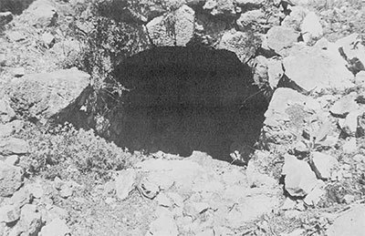
Already, at the very beginning of the Roman construction where the fiercely coursing river was tapped, the entrance has been lost under rock slides incident to the building of a small path above, used in the survey preparatory work on the dam area. I saw it a few years ago but cannot find it now. It was a rectangular opening about one meter square, made of four heavy stone slabs, beautifully fitted.
The channel quickly buries itself in the banks, to reappear now and then for several hundred meters downstream in courses chiseled on the rock sides above the swiftly descending flood.
Further below, where the valley widens and flattens, the channel shows itself in more routine forms—if you can call anything about a Roman aqueduct routine—such as spans carried on arches over streams or short-cutting small ravines, or as vaulted tunnels of cemented stones, all retaining the standard width of about 1.5 meters. Although they are now for the most part silted up, they were doubtless initially close to two meters high, allowing a man to walk through comfortably.
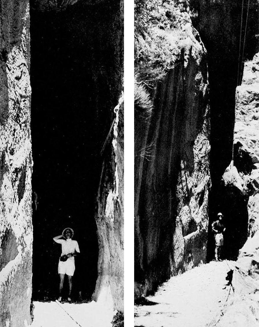
But where the canyon narrows again about four kilometers from the beginning of the aqueduct and the river cuts at a right angle through the southernmost great east-west ridge of the Taurus, the builders were confronted with a daunting construction problem. Here and there, where weathering and rockfalls had moderated the steep gradient of the canyon side, they could build their usual stone-and-cement tunnels (the path today crisscrosses them and the cement, at the top of the vaulting, harder than the day it was laid down, shows a telltale white under the feet). The real problem, though, was to make a passage through the living rock of the cliffs at the places where they rose, almost vertically, above the river that by this point had dropped ten to twenty meters below the level that had to be maintained by the aqueduct. There was no alternative but to claw a channel along the edge or, for short distances, through the mountain.
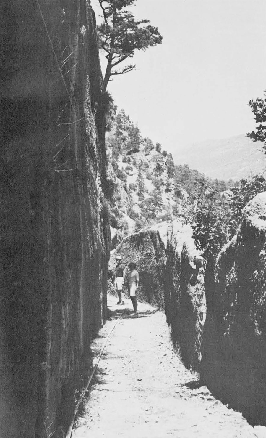
Where the contour was such that the channel could follow the cliff side without requiring too much winding about—that is, where the cliff did not curve too much or abut outwards too prominently—the simplest solution was to gouge out a trough, allowing the mass of rock above—what would have been an overhang—to tumble down and plunge into the river below. The resulting open trench was thus bounded by the cliff on one side; on the other side there was left an outer wall, part the original cliff side, about one and a half to two meters high and roughly half a meter thick.
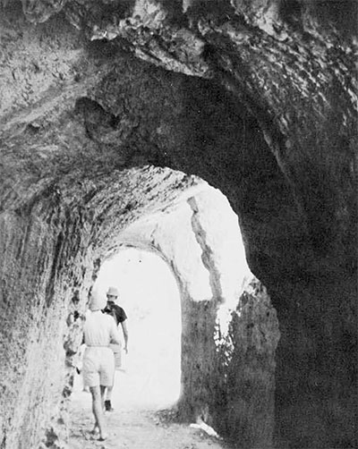
But where following the curve of the cliffs would have meant building a channel intolerably longer than a direct course, the Romans tunneled straight through the projections. They mined a passage that maintained the 1.5-meter width, as in the troughs and other tunnels, but the height varied, almost always with enough headroom for a man to walk through without stooping, but occasionally much higher. One section, several meters long at the entrance of one hewn tunnel, has walls that rise to fourteen meters on both sides. I have no explanation for what seems like a piece of inordinate and unnecessary work, although some more knowledgeable reader may. In some sections where the roof seems needlessly high at first glance, it can be seen on closer examination that there had been loose rock or boulders above that could not be safely left as they were; but in this tallest cut of all it is bedrock to the topmost chisel mark.
Occasionally, where the tunnels emerged into troughs at the cliff’s edge, but where the overhang was too massive to be cleared away entirely, the water-course becomes half-tunnel, half-ditch. That is, openings were cut above the two-meter level of the outer wall with the stone left in place looking like frames or, occasionally, flying buttresses—in which capacity, of course, they actually served.
From its source to the entrance in the second storey of the great city wall of Side, the water channel falls about thirty meters, making the ratio of its drop about 1/1000. Professor Arif Mufid Mansel of the University of Istanbul, the venerable dean of Pamphylian archaeologists, believes that it was gravity flow throughout. I have found one spot, however, that entirely baffles me: there is a sharp, unmistakable rise of a meter or two in the neatly chiseled channel floor on its downhill course. The terrain at this spot has been so badly swept away by rock slides as to have destroyed the fifteen to twenty meters of the section of the aqueduct preceding the rise, so a satisfactory explanation is hard to come by. Such an anomaly in a system so punctiliously engineered for gravity flow everywhere else would be incongruous. But how to explain the indisputable rising? That the Romans did understand how to take water uphill through pressure in a closed system—contrary to erstwhile folklore—is now well known (see “Roman Aqueducts,” Expedition, Fall 1970) and beautifully demonstrated by the great syphon from hilltop to hilltop at Aspendus, thirty kilometers west of Side, in what Professor George E. Bean of the University of Istanbul considers the best surviving example of any Roman aqueduct.
The one that brought the pure water to Side, ice cold at all seasons, is known from inscriptions recovered there by Mansel to have become dilapidated or worse by the first half of the third century A.D. It was restored by a rich Sideten named Bryonianos Lollianos, to whom statues were erected in every quarter of the city, their bases carrying appropriate tributes that told how the water had disappeared but that, thanks to his beneficence, the “river” had been brought back into the city and its fountains.
But what the second and third century Romans could do, today’s inhabitants have not yet duplicated. Earthquakes and Arab raids which ravaged Turkey’s southern shores from the seventh to tenth centuries left the great Roman constructions in ruins, undisturbed and even un looked at for a millennium. Side was deserted, not to be resettled until the turn of this century, when a band of Turks from Crete, fleeing political difficulties much like those in today’s Cyprus, came back to their homeland and set up a little village on the ancient site. Today it consists of about six hundred fishermen, farmers and, increasingly, caterers to tourists. Yet, under the shadow of the great aqueduct, around the ruins of the elaborately decorated fountains and what is probably the finest nymphaeum in Asia Minor, today’s inhabitants get their water from brackish wells and—if they are particular—lug jerry cans to springs three kilometers distant for drinking water.
There is hope that within the year clean water, the first in more than a thousand years, may be piped in. If so, I trust that the good citizens of Side will honor the water engineer of the province of Antalya with the modern equivalent of the panegyric the ancient Sidetens inscribed to Lollianos:
Near the temple of the Nymphs, let your likeness be erected,
Endower of the principal gate, named the Great, Rejoicing you here by the current of the river sprung from Heaven;
For, with noble spirit you built at your cost
The unmeasurable river from its source to here.